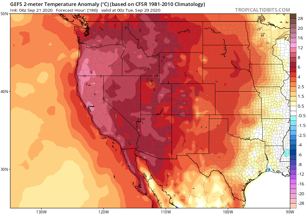
In case you missed it: a "thread of threads" highlighting some of our collaborative research from 2020. How are wildfires, atmospheric rivers, floods, and other extreme events changing in a warming #climate (and in California specifically)? Read on for details: (1/8) #CAwater
A general-audience primer on the rapidly advancing science of "extreme event attribution." How do scientists approach question of whether #ClimateChange is affecting likelihood and/or severity of extreme weather events? (2/8) @ClimateChirper @danielletouma
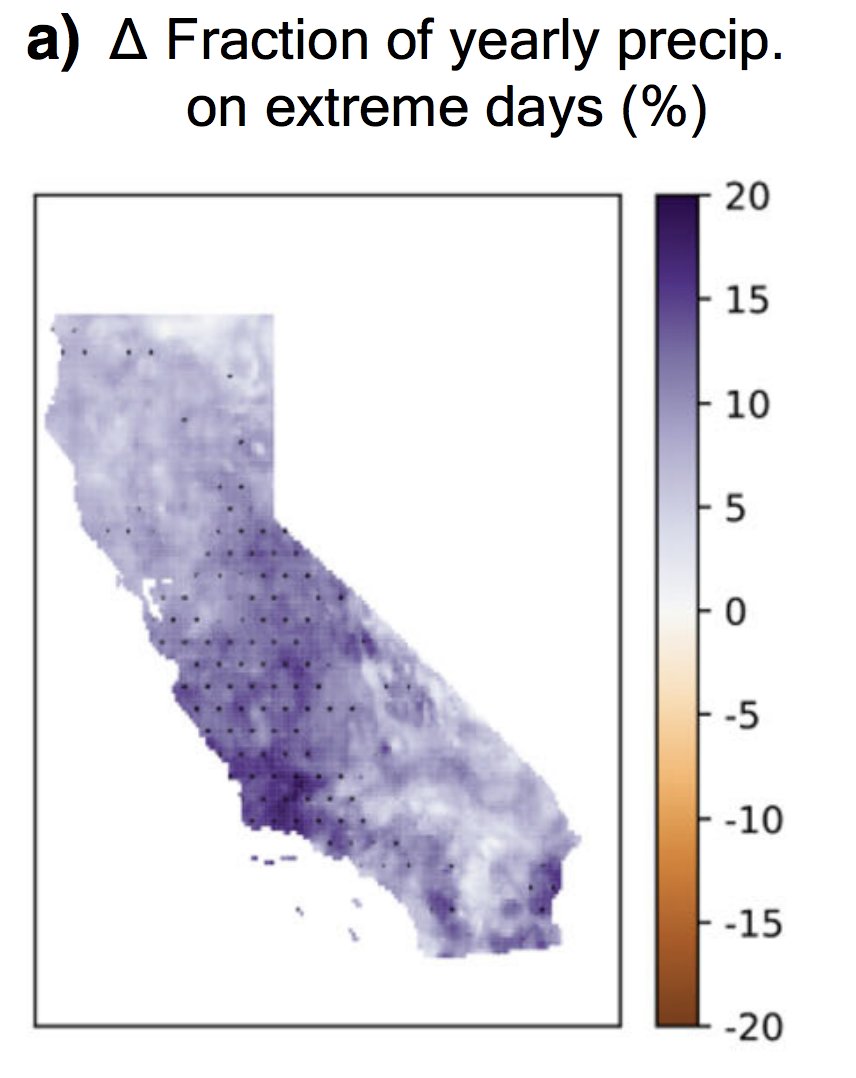
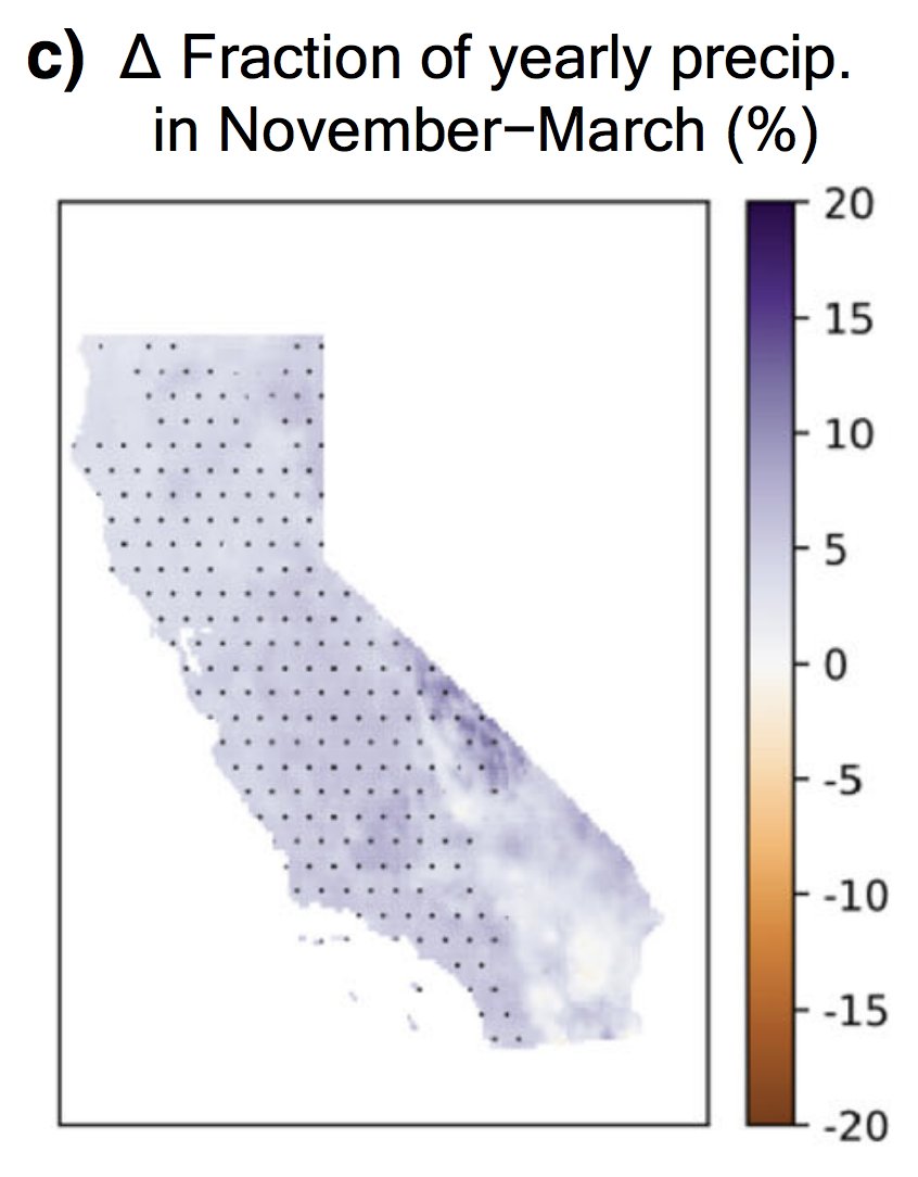
Our deep dive into extreme #AtmosphericRiver storms in California and how they are likely to warm & intensify considerably due to #ClimateChange. (3/8) @xingyhuang @ProfAlexHall
An exploration of how climate models are in stronger agreement than one might expect regarding changes in California hydroclimate extremes, despite greater uncertainty in mean changes. (4/8) @ggpersad @PabloWater
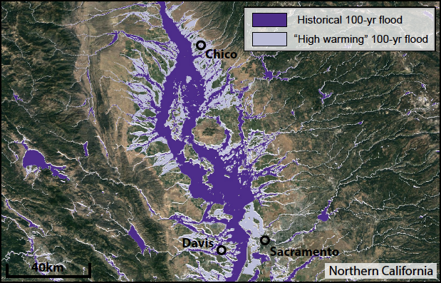
A U.S.-wide assessment of how projected increases in high-end extreme precipitation events due to #ClimateChange might affect the flood risk and population exposure. (5/8) @Climate_Done @oejwing @KrisAJohnson
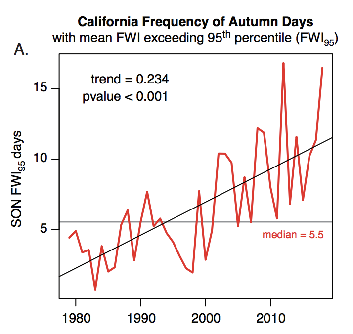
Our work, motivated by the dramatic recent escalation in California wildfire catastrophes, showing that #ClimateChange has already doubled the occurrence of extreme fire conditions during peak autumn fire season. (6/8) @climate_guy @pyrogeog
A new characterization of the different wind vs. moisture-dominant "flavors" of West Coast atmospheric rivers. (7/8) @k_r_gonz @atmosbarnes
And most recently, just-published work showing that the spatial extent of streamflow drought events in the continental U.S. is increasing in a warming climate. (8/8) @ManuelaIBrunner

• • •

Missing some Tweet in this thread? You can try to force a refresh
 

Keep Current with Daniel Swain

Daniel Swain Profile picture

Stay in touch and get notified when new unrolls are available from this author!

Read all threads

This Thread may be Removed Anytime!

PDF

Twitter may remove this content at anytime! Save it as PDF for later use!

Try unrolling a thread yourself!

how to unroll video
  1. Follow @ThreadReaderApp to mention us!

  2. From a Twitter thread mention us with a keyword "unroll"
@threadreaderapp unroll

Practice here first or read more on our help page!

More from @Weather_West

26 Oct
First, some good news: NorCal seems to have made through initial (extreme wind) phase of this critical fire weather event relatively unscathed. Few new small fires, but nothing unmanageable. A few thoughts as to why this was the case: #CAwx #CAfire
Very strong to extreme winds and exceptionally low humidity did materialize, despite an initial delay. A peak Bay Area gust of 89mph (with fairly widespread gusts above 50-60 mph), and peak Sierra Nevada gusts well over 100mph, were recorded. #CAwx #CAfire
In some spots, extreme winds did indeed mix down to low elevations (interior North Bay Valleys; Oakland Airport; San Francisco; Half Moon Bay). But some locations closer to sea level saw little wind,so sea level gusts were somewhat less widespread than initially anticipated.#CAwx
Read 6 tweets
25 Oct
Folks: major wind/extreme low humidity/fire weather event is still coming--it just might be slightly delayed (by a couple hours or so in SF Bay Area). Very surprised to hear that PG&E is cancelling some of the planned PSPS with strong winds still inbound?? #CAwx #CAfire
Are @NWSBayArea or @NWSSacramento aware of any major forecast changes that would explain why PG&E is claiming that conditions will no longer justify a PSPS (at least in portions of East Bay Hills and Sierra foothills)? I certainly am not...
cc @RobMayeda @psuweatherman I am genuinely baffled here.
Read 4 tweets
22 Oct
This is the fire weather forecast I was hoping wouldn't come to pass, given all that has already transpired in 2020: Very strong offshore winds, coupled w/exceptionally low humidity & record-dry vegetation, will bring extremely critical wildfire risk Sun/Mon. 1/3 #CAwx #CAfire Image
This will likely be strongest & most widespread offshore wind event of season, & is reminiscent of extreme events in 2019 & 2017. Hardest-hit areas appear to be west slopes of Sierra Nevada (gusts of 70+mph) & SF Bay Area (widespread gusts 40-50mph; higher in hills). #CAwx Image
Exceptionally low atmospheric humidity (relative humidity of 5% or less and dewpoints below zero F) will accompany these strong winds. This will be a *cold* offshore wind event, and temperatures will drop precipitously (especially in mountains). #CAwx ImageImage
Read 4 tweets
7 Oct
New research led by @ggpersad & featuring @PabloWater. Using downscaled climate model simulations, we show that there is unexpectedly high inter-model agreement re: increasing extremity of California hydroclimate due to #ClimateChange. (1/n) link.springer.com/article/10.100… #CAwater
In general, climate models agree than an increasing fraction of California's overall precipitation will become concentrated into the most intense events--and that the most extreme precip events will themselves be substantially more intense. (2/n) link.springer.com/article/10.100… #CAwater
There is also agreement that CA's already pronounced precipitation seasonality will become even sharper--with more rain concentrated into winter months at expense of the autumn & spring. Consider the wildfire season implications... (3/n) link.springer.com/article/10.100… #CAwater #CAfire
Read 8 tweets
21 Sep
Fire weather update: relatively mild (near avg) temps will continue for a few more days across California. Calmer winds will result in poor air quality, as visible this AM. A weak cold front with a few light North Coast showers possible mid-week. But then... #CAwx #CAfire (1/n)
There is unfortunately multi-model ensemble agreement that a very strong ridge will build near CA and the West Coast by end of Sept., bringing yet another major heatwave by early October to CA, OR, and adjacent states. #CAwx #ORwx #CAfire (2/n)
Early indications is that this early Oct event will have potential to bring record heat to CA and possibly other areas. This will coincide with weak offshore flow, so should spread all the way to coast and bring extreme wildfire burning conditions once again. #CAwx #CAfire (3/n)
Read 4 tweets
7 Sep
You could write an entire meteorology textbook just based on the phenomena visible from this afternoon's wild satellite imagery looking down at the American West. (Thread) #CAwx #WAwx #ORwx #COwx #UTwx #MTwx #IDwx
Most prominent is incredibly strong early-season cold front plunging southward from Canada and currently stretching along a roughly east-west axis from Eastern Washington to North Dakota. Clouds are rapidly developing behind the front as cold air replaces a very hot airmass.
Next, there are numerous large wildfire smoke plumes visible in nearly every state not covered by clouds--including Washington, Oregon, California, Utah, Idaho, and Colorado. The total smoke volume is massive, and extends across most of the continental U.S.
Read 7 tweets

Did Thread Reader help you today?

Support us! We are indie developers!


This site is made by just two indie developers on a laptop doing marketing, support and development! Read more about the story.

Become a Premium Member ($3/month or $30/year) and get exclusive features!

Become Premium

Too expensive? Make a small donation by buying us coffee ($5) or help with server cost ($10)

Donate via Paypal Become our Patreon

Thank you for your support!

Follow Us on Twitter!