Thread on very strong inbound CA storm. A cold & clear morning will quickly give way to increasing clouds, NorCal valley rain & snow down to 1,500-2,000 ft (locally lower) later this PM. Current satellite imagery shows this strengthening system off the coast. (1/10) #CAwx
Tonight, a rapidly intensifying cold front will sweep across NorCal. This front will be unusually well defined, for a CA winter storm, and will replace an already cold airmass with...another cold airmass! (2/10) #CAwx
The cold frontal passage is expected to be quite dramatic across NorCal in the overnight hours. A convective "narrow cold frontal rainband" (NCFR) will likely develop, which could bring a period of torrential rain or snow to many areas, as well as possible lightning. (3/10) #CAwx
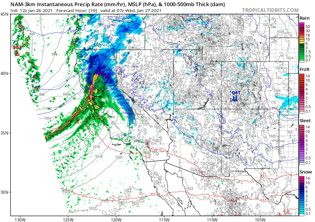
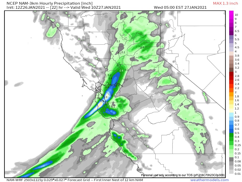
Extremely heavy precipitation is possible for a 30-60+ minute period when this NCFR feature moves ashore. Over an inch of rain could fall per hour in some spots. This portion of the event poses a high threat of debris flows in/near recently burned areas. (4/10) #CAwx
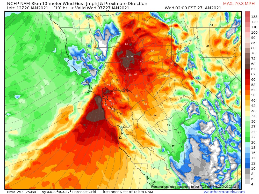
In addition to torrential rainfall, the cold front/NCFR will be accompanied by very strong wind gusts across much of NorCal. In fact, high-res models are suggesting potential for gusts of 60-70 mph even in lower elevation places. Widespread power outages possible. (5/10) #CAwx
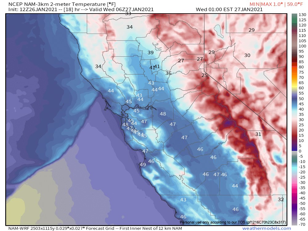
Meanwhile across the northern and central Sacramento Valley, a very rare heavy snowfall event will unfold. Some places near the Valley floor (near Redding and even Red Bluff) could see a foot or more of accumulation (!). Some lighter snow possible even south of that. (6/10) #CAwx
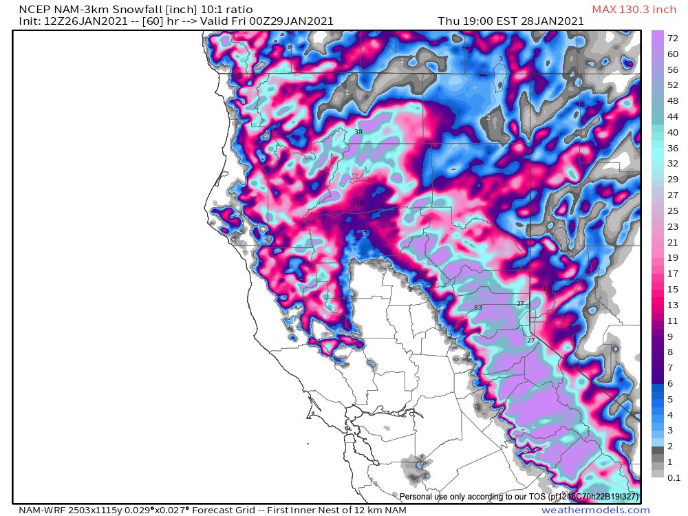
That very rare, heavy & wet snowfall in the North Valley could lead to widespread disruption and power outages. Meanwhile, extremely heavy snowfall (multiple feet) is likely at slightly higher elevations above 2,000ft. Mountain travel may become impossible. (7/10) #CAwx
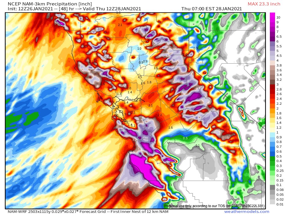
Then, on Wednesday, the #AtmosphericRiver/associated cold frontal rainband will likely stall along Central Coast (near border of Monterey/SLO counties). High-res models are suggesting potential for *extreme* 48hr rainfall accums, & very high flood/mudslide risk there. (8/10)#CAwx
The Hwy corridor and Big Sur, as well as the Dolan/River Fire footprints, appear to be at very high risk in this scenario. Other models aren't quite as aggressive with rainfall totals here, but still suggest a high likelihood of 10-15 inches. (9/10) #CAwx
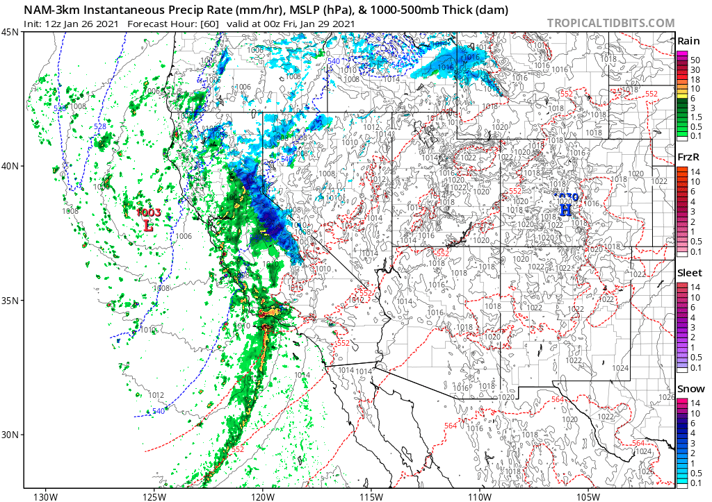
Finally, on Thurs, the cold front/AR will shift southward down the coast. Impacts will be less severe in SoCal than across northern&central CA, but this will still be a pretty robust system as it brings a briefer period of heavy rain/snow to SoCal. (10/10) #CAwx
The new @NWSBayArea morning forecast discussion uses some very pointed language regarding risks associated with potentially extreme rainfall near Big Sur over the next 48 hours. #CAwx

• • •

Missing some Tweet in this thread? You can try to force a refresh
 

Keep Current with Daniel Swain

Daniel Swain Profile picture

Stay in touch and get notified when new unrolls are available from this author!

Read all threads

This Thread may be Removed Anytime!

PDF

Twitter may remove this content at anytime! Save it as PDF for later use!

Try unrolling a thread yourself!

how to unroll video
  1. Follow @ThreadReaderApp to mention us!

  2. From a Twitter thread mention us with a keyword "unroll"
@threadreaderapp unroll

Practice here first or read more on our help page!

More from @Weather_West

22 Dec 20
In case you missed it: a "thread of threads" highlighting some of our collaborative research from 2020. How are wildfires, atmospheric rivers, floods, and other extreme events changing in a warming #climate (and in California specifically)? Read on for details: (1/8) #CAwater
A general-audience primer on the rapidly advancing science of "extreme event attribution." How do scientists approach question of whether #ClimateChange is affecting likelihood and/or severity of extreme weather events? (2/8) @ClimateChirper @danielletouma
Our deep dive into extreme #AtmosphericRiver storms in California and how they are likely to warm & intensify considerably due to #ClimateChange. (3/8) @xingyhuang @ProfAlexHall
Read 8 tweets
26 Oct 20
First, some good news: NorCal seems to have made through initial (extreme wind) phase of this critical fire weather event relatively unscathed. Few new small fires, but nothing unmanageable. A few thoughts as to why this was the case: #CAwx #CAfire
Very strong to extreme winds and exceptionally low humidity did materialize, despite an initial delay. A peak Bay Area gust of 89mph (with fairly widespread gusts above 50-60 mph), and peak Sierra Nevada gusts well over 100mph, were recorded. #CAwx #CAfire
In some spots, extreme winds did indeed mix down to low elevations (interior North Bay Valleys; Oakland Airport; San Francisco; Half Moon Bay). But some locations closer to sea level saw little wind,so sea level gusts were somewhat less widespread than initially anticipated.#CAwx
Read 6 tweets
25 Oct 20
Folks: major wind/extreme low humidity/fire weather event is still coming--it just might be slightly delayed (by a couple hours or so in SF Bay Area). Very surprised to hear that PG&E is cancelling some of the planned PSPS with strong winds still inbound?? #CAwx #CAfire
Are @NWSBayArea or @NWSSacramento aware of any major forecast changes that would explain why PG&E is claiming that conditions will no longer justify a PSPS (at least in portions of East Bay Hills and Sierra foothills)? I certainly am not...
cc @RobMayeda @psuweatherman I am genuinely baffled here.
Read 4 tweets
22 Oct 20
This is the fire weather forecast I was hoping wouldn't come to pass, given all that has already transpired in 2020: Very strong offshore winds, coupled w/exceptionally low humidity & record-dry vegetation, will bring extremely critical wildfire risk Sun/Mon. 1/3 #CAwx #CAfire Image
This will likely be strongest & most widespread offshore wind event of season, & is reminiscent of extreme events in 2019 & 2017. Hardest-hit areas appear to be west slopes of Sierra Nevada (gusts of 70+mph) & SF Bay Area (widespread gusts 40-50mph; higher in hills). #CAwx Image
Exceptionally low atmospheric humidity (relative humidity of 5% or less and dewpoints below zero F) will accompany these strong winds. This will be a *cold* offshore wind event, and temperatures will drop precipitously (especially in mountains). #CAwx ImageImage
Read 4 tweets
7 Oct 20
New research led by @ggpersad & featuring @PabloWater. Using downscaled climate model simulations, we show that there is unexpectedly high inter-model agreement re: increasing extremity of California hydroclimate due to #ClimateChange. (1/n) link.springer.com/article/10.100… #CAwater
In general, climate models agree than an increasing fraction of California's overall precipitation will become concentrated into the most intense events--and that the most extreme precip events will themselves be substantially more intense. (2/n) link.springer.com/article/10.100… #CAwater
There is also agreement that CA's already pronounced precipitation seasonality will become even sharper--with more rain concentrated into winter months at expense of the autumn & spring. Consider the wildfire season implications... (3/n) link.springer.com/article/10.100… #CAwater #CAfire
Read 8 tweets
21 Sep 20
Fire weather update: relatively mild (near avg) temps will continue for a few more days across California. Calmer winds will result in poor air quality, as visible this AM. A weak cold front with a few light North Coast showers possible mid-week. But then... #CAwx #CAfire (1/n)
There is unfortunately multi-model ensemble agreement that a very strong ridge will build near CA and the West Coast by end of Sept., bringing yet another major heatwave by early October to CA, OR, and adjacent states. #CAwx #ORwx #CAfire (2/n)
Early indications is that this early Oct event will have potential to bring record heat to CA and possibly other areas. This will coincide with weak offshore flow, so should spread all the way to coast and bring extreme wildfire burning conditions once again. #CAwx #CAfire (3/n)
Read 4 tweets

Did Thread Reader help you today?

Support us! We are indie developers!


This site is made by just two indie developers on a laptop doing marketing, support and development! Read more about the story.

Become a Premium Member ($3/month or $30/year) and get exclusive features!

Become Premium

Too expensive? Make a small donation by buying us coffee ($5) or help with server cost ($10)

Donate via Paypal Become our Patreon

Thank you for your support!

Follow Us on Twitter!