(1) Loof Science II - Chapter 5: A more speculative theory about Tracks #1-A and #1-B
What if the person who laid Track #1-A, came back later and tried to retrace his/her steps, and that created Track #1-B, or vice versa.
What if the person who laid Track #1-A, came back later and tried to retrace his/her steps, and that created Track #1-B, or vice versa.

(2) Our current theory of the 22 calls is that Ryan H claimed to have discovered the RAV4 on 11/03 or 11/04, and then came back, perhaps with Mike H, to confirm its location for Law Enforcement.

(3) Perhaps Track #1-A was Ryan Hillegas coming back out after finding or planting the RAV4, and Track #1-B was Ryan trying to retrace his steps with Mike Halbach.
Without a scent dog, Ryan would retrace the path imperfectly.
Without a scent dog, Ryan would retrace the path imperfectly.

(4) Given this working theory, Ryan and Mike may have parked at Box B, walked around Wilmer's home as Ryan explained he had searched it (Box C), and then walked back to the car and up to the deer camp (Box A).

(5) Ryan and Mike may have had bright flashlights, which caught Chuck Avery's attention just before 7:20pm on 11/04.
Path #1-A may be their egress route, or it may be the route the RAV4 planter took.
Path #1-A may be their egress route, or it may be the route the RAV4 planter took.

(6) Hypothetically, if we take Ryan at his word, Track #1-B could be the ingress route and Track #1-A could be the egress route. They may have moved their car from Box B to Box A while ingressing.

(7) Of course this all is speculative, because it depends on my explanation for the 22 calls on 11/04 from the "NO CALL ID" caller to Ryan. We think the caller was likely CASO Law Enforcement, and Ryan was in the pit with a large flashlight on foot just before 7:20pm.

(8) If Ryan did find the RAV4 during a wild night of searching on 11/03-04, after CASO told friends gathered at Teresa's home that they suspected Steven Avery, the event would be very suspicious.
Of course the idea that they all spent the night "planning" is ludicrous.
Of course the idea that they all spent the night "planning" is ludicrous.

(9) It's my understanding that Ryan Hillegas has not been willing to publicly explain the 22 "NO CALL ID" incoming calls he received on 11/04 between about 3:11pm, just after the flyover, and ending at 7:30pm, just after "the lights in the pit".

(10) The first call was at 3:11pm, and the unusual "D" call code started at 4:15pm, 64 minutes later.
That's long enough to travel from Shiocton, WI, where his sister Tara lived, to the vicinity of the Avery Auto Salvage Yard at the speed limit with a few minutes to spare.
That's long enough to travel from Shiocton, WI, where his sister Tara lived, to the vicinity of the Avery Auto Salvage Yard at the speed limit with a few minutes to spare.

(11) The 64 minutes is also more than enough to meet up with Mike Halbach and drive from Teresa's home to the Avery Auto Salvage Yard.
That trip is estimated to take 39 minutes at current speed limits.
That trip is estimated to take 39 minutes at current speed limits.

(12) After Ryan received the first "NO CALL ID" incoming call, he received a call from his sister Tara only minutes after hanging up, and he received a call from Mike Halbach at 3:41pm.
He also received two mobile-to-mobile calls from an unidentified caller at 920-740-3931.
He also received two mobile-to-mobile calls from an unidentified caller at 920-740-3931.

(13) If anyone can identify the person who had this phone number in November of 2005, please provide the information to the public.
The number once again is 920-740-3931.
The prefix was originally issued for wireless phones in Appleton, WI.
The number once again is 920-740-3931.
The prefix was originally issued for wireless phones in Appleton, WI.

(14) The calls immediately after the block of "NO CALL ID" incoming calls may be of interest.
Brian Halbach called at 7:50pm, then Ryan made a short outgoing call to Atlanta & a 4 min call to Kelly Pitzen after that.
There also are other numbers w/the 920-740 exchange.
Brian Halbach called at 7:50pm, then Ryan made a short outgoing call to Atlanta & a 4 min call to Kelly Pitzen after that.
There also are other numbers w/the 920-740 exchange.

(15) If I'm right about the RAV4 being there during the 11/04 flyover, the planting of the RAV4 occurred before 3:00pm on 11/04.
Ryan later could have laid these tracks between 4:15pm and 7:30pm on 11/04: an ingress trail and an egress trail.
Ryan later could have laid these tracks between 4:15pm and 7:30pm on 11/04: an ingress trail and an egress trail.


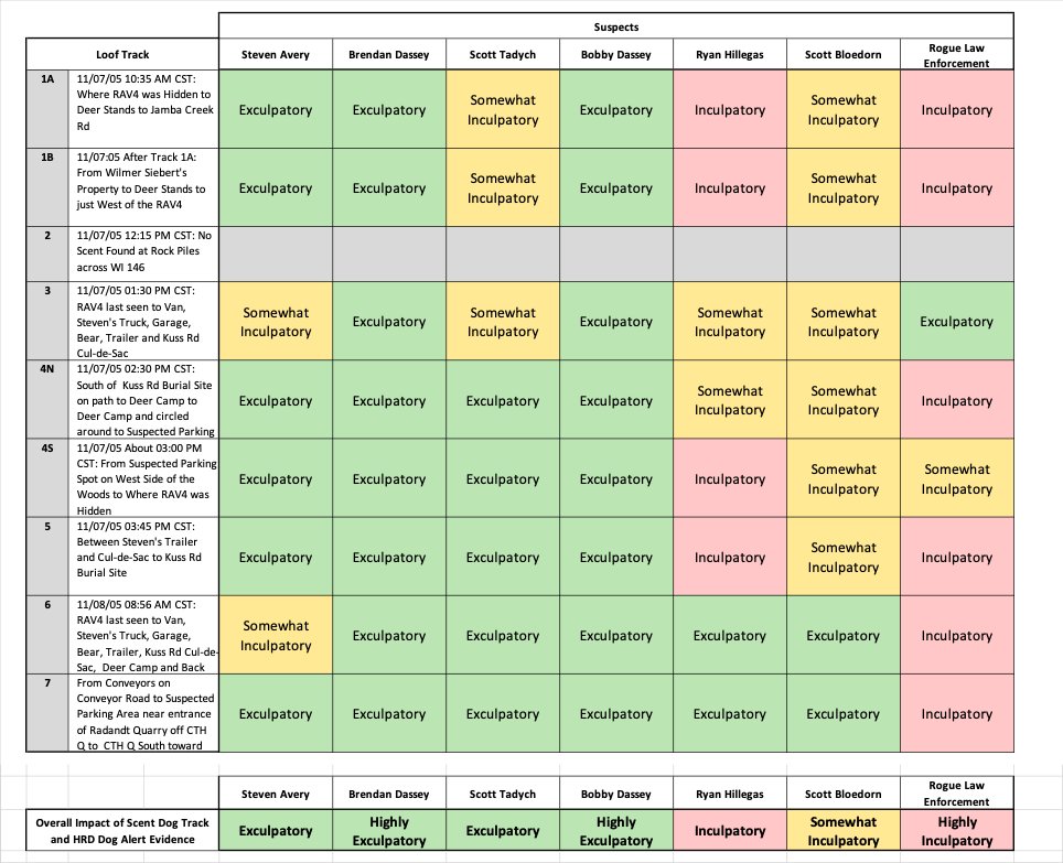
(16) Completing the summary table for Tracks #1-A and #1-B.

(18) ETA: Regarding the phone number 920-989-1079
I have it in my database as Brian Halbach, but I haven't been able to confirm my source. It is not listed in the CASO report.
I can confirm Tom and Karen at 920-989-1098, and Scott Bloedorn and Teresa at 920-989-2911.
I have it in my database as Brian Halbach, but I haven't been able to confirm my source. It is not listed in the CASO report.
I can confirm Tom and Karen at 920-989-1098, and Scott Bloedorn and Teresa at 920-989-2911.


(19) ETA: I have been able to verify that Brian Halbach once had this number via 411.info.
411.info/people/Brian-H…
411.info/people/Brian-H…
(20) ETA: I believe Brian was Mike and Teresa Halbach's older brother, who was about 29 years old at the time of the incident.
His calling Ryan immediately after the suspected CASO/Ryan caper suggests to me that the Halbach family was standing by and perhaps notified by CASO.
His calling Ryan immediately after the suspected CASO/Ryan caper suggests to me that the Halbach family was standing by and perhaps notified by CASO.

(21) ETA: My explanation for Ryan Hillegas' 22 "NO CALL ID" calls is the best one I've heard, but it is still just a working theory.
If you have a good working theory, please feel free to share it.
If you have a good working theory, please feel free to share it.

(21) ETA: Tim is the older brother, so Brian must be a cousin living near Hilbert.
I think this picture is:
Mike/Bro, Karen/Mom, Tim/Bro, Teresa (front row),
Katie/Sis, Kelly/Sis (middle row),
Tom/Stepfather (standing in back).
I think this picture is:
Mike/Bro, Karen/Mom, Tim/Bro, Teresa (front row),
Katie/Sis, Kelly/Sis (middle row),
Tom/Stepfather (standing in back).

(22-1) ETA: Was the Ryan Kilgus group searching near Wilmer Siebert's property on Monday, November 7th?
Let's look at the map Ryan gave Law Enforcement (LE), that LE innocently wrote Kilgus on, and the map Ryan wrote on during pre-trail testimony showing his team's search areas.
Let's look at the map Ryan gave Law Enforcement (LE), that LE innocently wrote Kilgus on, and the map Ryan wrote on during pre-trail testimony showing his team's search areas.


(22-2) ETA: Which of these homes was Ryan referring to?
These blow-ups aren't very clear, are they?
These blow-ups aren't very clear, are they?


(22-3) When we look at a contemporary satellite photo of the house that Ryan put the "X" on, we see that the home is actually where Ryan labeled Garage, and two large Barns are where Ryan labeled the house.
We also don't see a fence.
We also don't see a fence.


(22-4) The second house doesn't match Ryan's drawing, either.


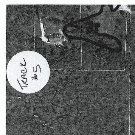
(22-5) Here's Loof Track #1 (left) a 2021 satellite view (right) of Area B, where a car might have parked and Wilmer Siebert's property, Area C.


(22-6) Here is the Property that Ryan put an "X" on in December, 2004 and in June, 2015. It has barely changed.


(22-7) Why did Ryan provide this inaccurate map to Law Enforcement?
Do you believe Ryan thought a condom wrapper (not the condom) was a pressing matter?
Where was Ryan when he gave this map to Law Enforcement, anyone know? Was this a cover story?
Do you believe Ryan thought a condom wrapper (not the condom) was a pressing matter?
Where was Ryan when he gave this map to Law Enforcement, anyone know? Was this a cover story?

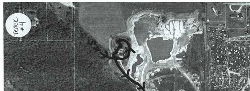
(22-8) The path, where I believe they could have hidden the Jeep while planting the RAV4 ("A"), used to be a two lane road. It has slowly been overgrown.
April 22nd, 2000 (top left)
December 31, 2004 (top right)
May 31, 2005 (bottom left)
July 24, 2011 (bottom right)
April 22nd, 2000 (top left)
December 31, 2004 (top right)
May 31, 2005 (bottom left)
July 24, 2011 (bottom right)


(22-9) The evolution of the Kuss Rd cul-de-sac and deer camp.
Apr 22, 2000 (top left)
No home, larger tree clearing, 1 trailer
Dec 31, 2004 (top right)
Home, trees grow back in, gravel pit started, 3 trailers
May 31, 2005 (bottom left)
Jun 1, 2015 (bottom right)
2 trailers
Apr 22, 2000 (top left)
No home, larger tree clearing, 1 trailer
Dec 31, 2004 (top right)
Home, trees grow back in, gravel pit started, 3 trailers
May 31, 2005 (bottom left)
Jun 1, 2015 (bottom right)
2 trailers


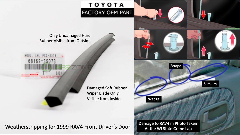
(23-1) Summary of the evidence that the RAV4 had been broken into since it was last cleaned.
Wiper blade edge of weatherstripping shows Slim Jim and Wedge damage.
Window shows scraping of dirt film above Slim Jim damage and between Slim Jim and Wedge damage.
Photo: WI SCL
Wiper blade edge of weatherstripping shows Slim Jim and Wedge damage.
Window shows scraping of dirt film above Slim Jim damage and between Slim Jim and Wedge damage.
Photo: WI SCL
(23-2) Additional evidence that RAV4 Rear Driver Side Door had been tampered with to gain entry prior to Pam and Nikole Sturm discovering it.
Photos on Right: Pamela and Nikole Sturm.
Photos on Right: Pamela and Nikole Sturm.

(23-3) Note that only the Hard Rubber Weatherstripping is visible from outside the RAV4 in Pamela & Nikole Sturm's picture of the RAV4.
The dirt pattern may reveal some of the scraping, but I would need higher resolution images to be certain, especially w/the reflection & glare.
The dirt pattern may reveal some of the scraping, but I would need higher resolution images to be certain, especially w/the reflection & glare.


(23-4) Pam and Nikole Sturm Photo (left) v. Wisconsin State Crime Lab Photo (right):
Does the pattern of the dirt on the outside of the window change?
(Survey on next tweet in thread).
Does the pattern of the dirt on the outside of the window change?
(Survey on next tweet in thread).


(23-5) Does the pattern of dirt on the outside of the RAV4 window change between Pam & Nikole Sturm's photo and the Wisconsin State Crime Lab photo?
(23-6) @Joriz74 just provided this look-down satellite view from April, 2005.
You can clearly see there is a car path to area "A", and a second one near area "B", corroborating our suspicion that these were parking spots.
You can clearly see there is a car path to area "A", and a second one near area "B", corroborating our suspicion that these were parking spots.


(23-7) Why didn't the Wisconsin State Crime Lab report the weatherstripping damage, which was consistent with a Slim Jim and Wedge, on the RAV4 driver's door?
More buried exculpatory evidence? Yet another Denny violation?
More buried exculpatory evidence? Yet another Denny violation?


• • •
Missing some Tweet in this thread? You can try to
force a refresh