Dry lightning event of *some* magnitude is now looking increasingly likely across *some portions* of CA on Sun/Mon. Details to come. But first, some thoughts on potential wildfire risks posed if this comes to fruition. (Thread) #CAwx #CAfire
Usually, fewer than 1 in 10 lightning strikes actually ignites a wildland fire. These numbers can be higher if lightning is not accompanied by precip, or if lightning occurs under unusually dry conditions in dense vegetation. But in general, lightning ignition *rate* is low-ish.
A big problem thus arises when there are a very large number of dry lightning strikes. This occurred during the extraordinary and historic Aug 2020 event in Northern CA, where 10,000+ strikes were observed (and subsequently *hundreds* of fires were ignited).
The upcoming event on Sun/Mon will be different for several reasons--not the least of which is that it's very unlikely there will be nearly as many dry lightning strikes as occurred in Aug 2020. The overall meteorological set-up does not look as extraordinary. HOWEVER...
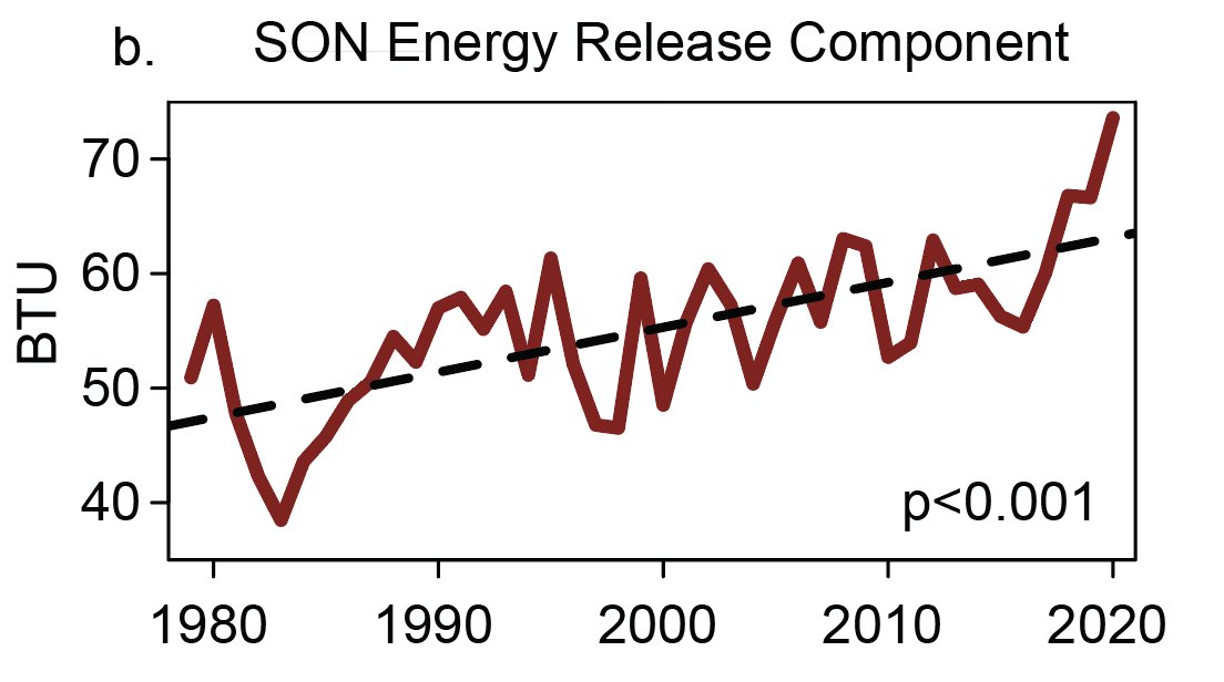
California is now experiencing a drought of extreme to exceptional severity. Soils and vegetation are now *much* drier than they were at this time last year across most of the state--historically dry in many cases.
This is especially true across CA interior (mountains & foothills), where recent weeks have brought a long period of unrelenting and frequently record-breaking heat. Here, vegetation is now *drier than typical peak August or September levels,* & at record levels for date. #CAfire
Along the immediate coast, however, things are quite different right now. A very robust marine layer has led to quite cool & damp conditions from fog and occasional drizzle in recent days. Hence, on coast side of SF Bay Area, fuels are much less dry than during last Aug event!
But the gradient is sharp: while vegetation along the immediate Bayside is relatively less dry, vegetation on the coastal hills (above 1000 ft elev) just a few miles away is *record dry* for the date due to the extreme drought and recent heatwaves. #CAfire
For this reason, & due to different trajectory of system, I don't think risk in immediate coastal CA is nearly as high as with Aug 2020 event. But elsewhere, especially across Sierra Nevada, northern mountains, and Central Valley foothills, risk is *higher* than Aug 2020! #CAfire
That may even include higher elevation areas near coast that are above marine layer. In fact, we could even see fairly bizarre cases of some lightning wildfires on hilltops above a shallow marine layer below! And inland, it's an entirely different world: risk will be quite high.
All in all: I am still pretty concerned about this upcoming potential dry lightning event Sun/Mon, even though it likely won't spark as many fires as Aug 2020 event, given worse drought preconditions inland this summer. Coastal areas may be at reduced risk, though. #CAfire #CAwx
More details to come later regarding actual lightning risk, and most likely hotspots. Some wetter storms are possible across portions of SoCal, as well.

• • •

Missing some Tweet in this thread? You can try to force a refresh
 

Keep Current with Daniel Swain

Daniel Swain Profile picture

Stay in touch and get notified when new unrolls are available from this author!

Read all threads

This Thread may be Removed Anytime!

PDF

Twitter may remove this content at anytime! Save it as PDF for later use!

Try unrolling a thread yourself!

how to unroll video
  1. Follow @ThreadReaderApp to mention us!

  2. From a Twitter thread mention us with a keyword "unroll"
@threadreaderapp unroll

Practice here first or read more on our help page!

More from @Weather_West

18 Jun
Posting as heads-up to weather modeling world (not as a realistic prediction of future conditions): the (new) GFS has occasionally been spitting out completely absurd surface temperatures for CA's Central Valley. 18z run today shows 128-130F. Anyone know what's up? Image
An intense and very possibly record-breaking heatwave is indeed possible in that interval, but not "hottest temperature in modern history" hot. I'm assuming it's the surface scheme, but then again, the 850mb temps are absurdly high also (though maybe feedback from sfc?). Image
Seems as if the ECMWF is now doing something similar. Either both models share some kind of similar surface scheme bias/error that involves sporadic positive/self-reinforcing surface temp feedback during extreme events (still by far most likely), or...hmm.
Read 4 tweets
7 Jun
Correction to give more accurate context: vegetation dryness & flammability metrics (1000hr fuel moisture & ERC, respectively) are indeed exceeding record levels for *calendar* date over most of Sierra Nevada, but *not* records for *any date.* (Phew!) (1/4) #CAwx #CAfire
For those interested, the confusion apparently arose due to a differing period of record for NorCal vs. SoCal data via the NorthOps/SouthOps GACCs. In SoCal, period of record is only ~10 years, so "any date" records less meaningful. So: data not wrong, but context is missing.
This really doesn't change the overall picture: there's still an exceptionally severe drought across all of Northern California and vegetation is still exceptionally dry--even relative to extreme values of recent years. But it's important to get the details right! (3/4)
Read 4 tweets
27 May
@MichaelWWara @jtemple As I've been emphasizing recently, the *predictable* aspects of Fire Season 2021 (soil moisture/vegetation dryness) are as bad or worse as any observed historically. The level of landscape flammability--especially in denser brush & forests--is genuinely scary. BUT... (1/2)
@MichaelWWara @jtemple ...A big part of what makes certain fire seasons exceptionally severe (from lives lost, homes burned, & ecosystems damaged perspective) has substantial random component. Do ignitions primarily occur during extreme fire wx? Do we see many heatwaves/wind/dry lightning events? (2/3)
@MichaelWWara @jtemple Latter aspects are largely not predictable in advance (except perhaps frequency of heatwaves--which are indeed expected to be elevated). In 2020, we were very unlucky w/all the unpredictable elements. I hope we won't be in 2021...but that's not a good management plan! (3/3)
Read 4 tweets
2 Mar
My perspective piece, "A shorter, sharper rainy season amplifies California wildfire risk," is now out in GRL. I discuss recent findings pointing toward shortening & sharpening wet season, & implications for ecology/wildfire. (1/17) #CAwx #CAfire #CAwater agupubs.onlinelibrary.wiley.com/doi/abs/10.102…
This perspective is in response to a recent analysis led by Jelena Luković showing that seasonal onset of CA precipitation has become progressively delayed (by ~1 month) in recent decades, w/ shorter but sharper rainy season. Underlying paper: agupubs.onlinelibrary.wiley.com/doi/full/10.10… (2)
Record heat, plus late arrival of seasonal rains, have played a key role in CA's extremely severe wildfire seasons in recent years. Autumn 2020 exemplified this trend: vegetation conditions were, by a wide margin, the most flammable on record.#CAfire agupubs.onlinelibrary.wiley.com/doi/abs/10.102… (3)
Read 18 tweets
1 Mar
March 1st update: 2020-2021 "wet season" in California remains dismally dry in most places. In fact, wide swaths of both NorCal & SoCal are well under 50% of average precipitation. It has also been a warmer than average winter overall, despite some cold interludes. #CAwx #CAwater
Statewide average snowpack has quickly fallen from late January highs (around 70-75% of average for the date) to around 61% of average for the date as of Mar 1. #CAwx #CAwater
Outside of a brief period of possible showers across coastal SoCal on Wednesday, the next ~5 days still look very dry across most of CA. #CAwx
Read 5 tweets
18 Feb
PSA: Relatively low-latitude, even sub-tropical, locations in central & eastern portions (but less frequently western portions) of continents can occasionally experience severe winter cold spells--like Texas is currently enduring. But how, & why this longitudinal asymmetry?(1/17)
Well, water has a tremendous ability to buffer against thermal extremes. This is because H20 has high heat capacity--around 4x that of land! This means that it takes around 4 times as much energy to raise the temperature of a given mass of water the same amount as land. (2/17)
An intuitive consequence is that regions near large bodies of water are usually milder than landlocked areas at a similar latitude. This is also why dry places have much larger diurnal temperature ranges than humid places. (3/17)
Read 17 tweets

Did Thread Reader help you today?

Support us! We are indie developers!


This site is made by just two indie developers on a laptop doing marketing, support and development! Read more about the story.

Become a Premium Member ($3/month or $30/year) and get exclusive features!

Become Premium

Too expensive? Make a small donation by buying us coffee ($5) or help with server cost ($10)

Donate via Paypal Become our Patreon

Thank you for your support!

Follow Us on Twitter!

:(