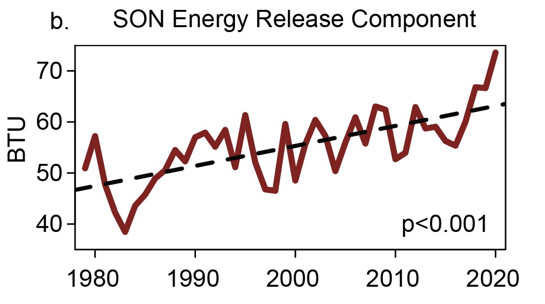
Correction to give more accurate context: vegetation dryness & flammability metrics (1000hr fuel moisture & ERC, respectively) are indeed exceeding record levels for *calendar* date over most of Sierra Nevada, but *not* records for *any date.* (Phew!) (1/4) #CAwx#CAfire
For those interested, the confusion apparently arose due to a differing period of record for NorCal vs. SoCal data via the NorthOps/SouthOps GACCs. In SoCal, period of record is only ~10 years, so "any date" records less meaningful. So: data not wrong, but context is missing.
This really doesn't change the overall picture: there's still an exceptionally severe drought across all of Northern California and vegetation is still exceptionally dry--even relative to extreme values of recent years. But it's important to get the details right! (3/4)
For clarity, I have deleted the original Tweet. Many thanks to several folks who have offered feedback and clarifications--especially @brunorodriguezq for asking around and officially getting to the bottom of this! (4/4)
• • •
Missing some Tweet in this thread? You can try to
force a refresh
@MichaelWWara@jtemple As I've been emphasizing recently, the *predictable* aspects of Fire Season 2021 (soil moisture/vegetation dryness) are as bad or worse as any observed historically. The level of landscape flammability--especially in denser brush & forests--is genuinely scary. BUT... (1/2)
@MichaelWWara@jtemple ...A big part of what makes certain fire seasons exceptionally severe (from lives lost, homes burned, & ecosystems damaged perspective) has substantial random component. Do ignitions primarily occur during extreme fire wx? Do we see many heatwaves/wind/dry lightning events? (2/3)
@MichaelWWara@jtemple Latter aspects are largely not predictable in advance (except perhaps frequency of heatwaves--which are indeed expected to be elevated). In 2020, we were very unlucky w/all the unpredictable elements. I hope we won't be in 2021...but that's not a good management plan! (3/3)
My perspective piece, "A shorter, sharper rainy season amplifies California wildfire risk," is now out in GRL. I discuss recent findings pointing toward shortening & sharpening wet season, & implications for ecology/wildfire. (1/17) #CAwx#CAfire#CAwateragupubs.onlinelibrary.wiley.com/doi/abs/10.102…
This perspective is in response to a recent analysis led by Jelena Luković showing that seasonal onset of CA precipitation has become progressively delayed (by ~1 month) in recent decades, w/ shorter but sharper rainy season. Underlying paper: agupubs.onlinelibrary.wiley.com/doi/full/10.10… (2)
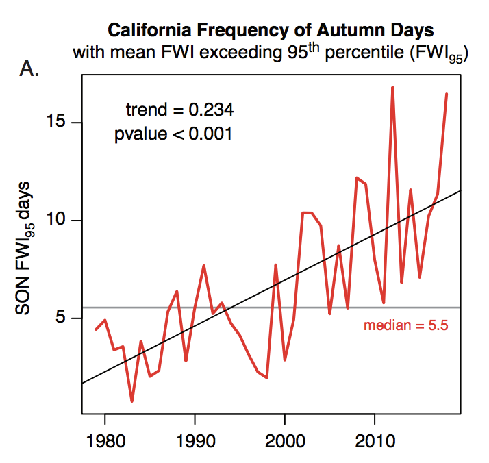
Record heat, plus late arrival of seasonal rains, have played a key role in CA's extremely severe wildfire seasons in recent years. Autumn 2020 exemplified this trend: vegetation conditions were, by a wide margin, the most flammable on record.#CAfireagupubs.onlinelibrary.wiley.com/doi/abs/10.102… (3)
March 1st update: 2020-2021 "wet season" in California remains dismally dry in most places. In fact, wide swaths of both NorCal & SoCal are well under 50% of average precipitation. It has also been a warmer than average winter overall, despite some cold interludes. #CAwx#CAwater
Statewide average snowpack has quickly fallen from late January highs (around 70-75% of average for the date) to around 61% of average for the date as of Mar 1. #CAwx#CAwater
Outside of a brief period of possible showers across coastal SoCal on Wednesday, the next ~5 days still look very dry across most of CA. #CAwx
PSA: Relatively low-latitude, even sub-tropical, locations in central & eastern portions (but less frequently western portions) of continents can occasionally experience severe winter cold spells--like Texas is currently enduring. But how, & why this longitudinal asymmetry?(1/17)
Well, water has a tremendous ability to buffer against thermal extremes. This is because H20 has high heat capacity--around 4x that of land! This means that it takes around 4 times as much energy to raise the temperature of a given mass of water the same amount as land. (2/17)
An intuitive consequence is that regions near large bodies of water are usually milder than landlocked areas at a similar latitude. This is also why dry places have much larger diurnal temperature ranges than humid places. (3/17)
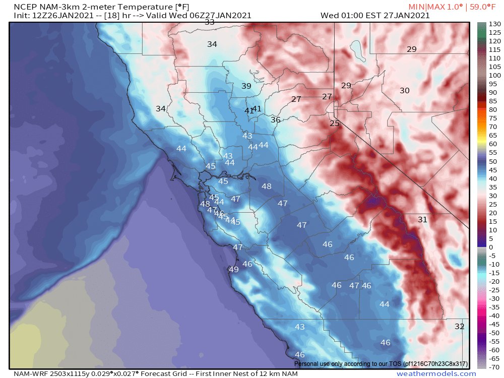
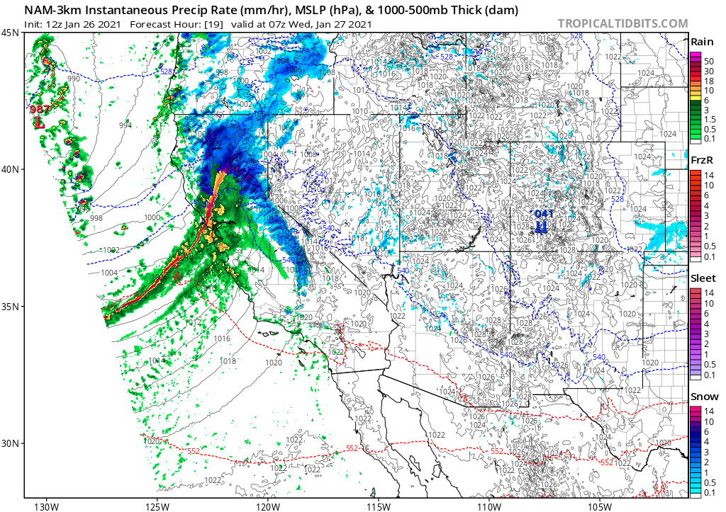
Thread on very strong inbound CA storm. A cold & clear morning will quickly give way to increasing clouds, NorCal valley rain & snow down to 1,500-2,000 ft (locally lower) later this PM. Current satellite imagery shows this strengthening system off the coast. (1/10) #CAwx
Tonight, a rapidly intensifying cold front will sweep across NorCal. This front will be unusually well defined, for a CA winter storm, and will replace an already cold airmass with...another cold airmass! (2/10) #CAwx
The cold frontal passage is expected to be quite dramatic across NorCal in the overnight hours. A convective "narrow cold frontal rainband" (NCFR) will likely develop, which could bring a period of torrential rain or snow to many areas, as well as possible lightning. (3/10) #CAwx
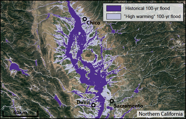
In case you missed it: a "thread of threads" highlighting some of our collaborative research from 2020. How are wildfires, atmospheric rivers, floods, and other extreme events changing in a warming #climate (and in California specifically)? Read on for details: (1/8) #CAwater
A general-audience primer on the rapidly advancing science of "extreme event attribution." How do scientists approach question of whether #ClimateChange is affecting likelihood and/or severity of extreme weather events? (2/8) @ClimateChirper@danielletouma