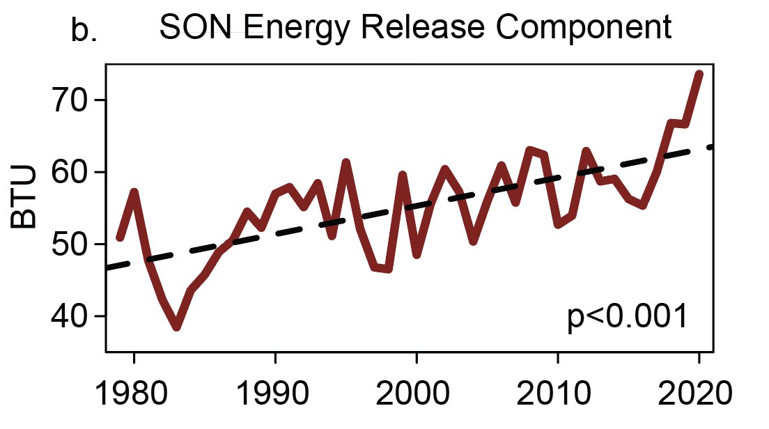
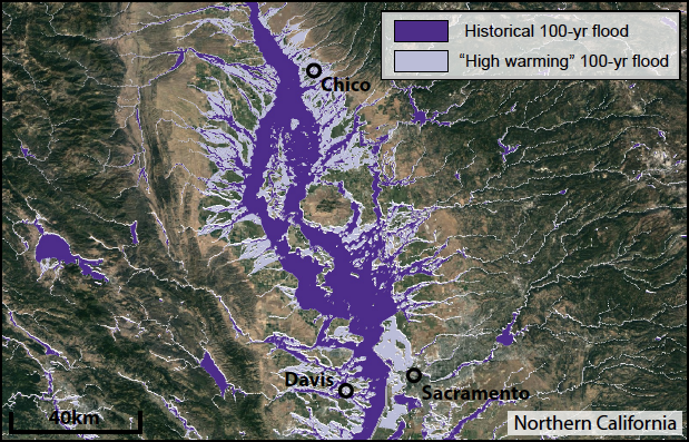
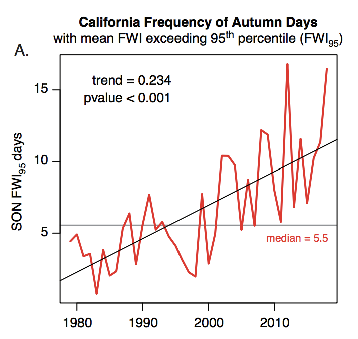
@MichaelWWara @jtemple As I've been emphasizing recently, the *predictable* aspects of Fire Season 2021 (soil moisture/vegetation dryness) are as bad or worse as any observed historically. The level of landscape flammability--especially in denser brush & forests--is genuinely scary. BUT... (1/2)
@MichaelWWara @jtemple ...A big part of what makes certain fire seasons exceptionally severe (from lives lost, homes burned, & ecosystems damaged perspective) has substantial random component. Do ignitions primarily occur during extreme fire wx? Do we see many heatwaves/wind/dry lightning events? (2/3)
@MichaelWWara @jtemple Latter aspects are largely not predictable in advance (except perhaps frequency of heatwaves--which are indeed expected to be elevated). In 2020, we were very unlucky w/all the unpredictable elements. I hope we won't be in 2021...but that's not a good management plan! (3/3)
@MichaelWWara @jtemple TL;DR version: I fully expect 2021 to be a very severe fire season in CA due to extraordinary level of vegetation dryness & overall drought. But 2020 was such an extreme outlier in CA that we shouldn't necessary expect 2021 to exceed it...despite even worse preconditions. #CAfire

• • •

Missing some Tweet in this thread? You can try to force a refresh
 

Keep Current with Daniel Swain

Daniel Swain Profile picture

Stay in touch and get notified when new unrolls are available from this author!

Read all threads

This Thread may be Removed Anytime!

PDF

Twitter may remove this content at anytime! Save it as PDF for later use!

Try unrolling a thread yourself!

how to unroll video
  1. Follow @ThreadReaderApp to mention us!

  2. From a Twitter thread mention us with a keyword "unroll"
@threadreaderapp unroll

Practice here first or read more on our help page!

More from @Weather_West

2 Mar
My perspective piece, "A shorter, sharper rainy season amplifies California wildfire risk," is now out in GRL. I discuss recent findings pointing toward shortening & sharpening wet season, & implications for ecology/wildfire. (1/17) #CAwx #CAfire #CAwater agupubs.onlinelibrary.wiley.com/doi/abs/10.102…
This perspective is in response to a recent analysis led by Jelena Luković showing that seasonal onset of CA precipitation has become progressively delayed (by ~1 month) in recent decades, w/ shorter but sharper rainy season. Underlying paper: agupubs.onlinelibrary.wiley.com/doi/full/10.10… (2)
Record heat, plus late arrival of seasonal rains, have played a key role in CA's extremely severe wildfire seasons in recent years. Autumn 2020 exemplified this trend: vegetation conditions were, by a wide margin, the most flammable on record.#CAfire agupubs.onlinelibrary.wiley.com/doi/abs/10.102… (3)
Read 18 tweets
1 Mar
March 1st update: 2020-2021 "wet season" in California remains dismally dry in most places. In fact, wide swaths of both NorCal & SoCal are well under 50% of average precipitation. It has also been a warmer than average winter overall, despite some cold interludes. #CAwx #CAwater
Statewide average snowpack has quickly fallen from late January highs (around 70-75% of average for the date) to around 61% of average for the date as of Mar 1. #CAwx #CAwater
Outside of a brief period of possible showers across coastal SoCal on Wednesday, the next ~5 days still look very dry across most of CA. #CAwx
Read 5 tweets
18 Feb
PSA: Relatively low-latitude, even sub-tropical, locations in central & eastern portions (but less frequently western portions) of continents can occasionally experience severe winter cold spells--like Texas is currently enduring. But how, & why this longitudinal asymmetry?(1/17)
Well, water has a tremendous ability to buffer against thermal extremes. This is because H20 has high heat capacity--around 4x that of land! This means that it takes around 4 times as much energy to raise the temperature of a given mass of water the same amount as land. (2/17)
An intuitive consequence is that regions near large bodies of water are usually milder than landlocked areas at a similar latitude. This is also why dry places have much larger diurnal temperature ranges than humid places. (3/17)
Read 17 tweets
26 Jan
Thread on very strong inbound CA storm. A cold & clear morning will quickly give way to increasing clouds, NorCal valley rain & snow down to 1,500-2,000 ft (locally lower) later this PM. Current satellite imagery shows this strengthening system off the coast. (1/10) #CAwx
Tonight, a rapidly intensifying cold front will sweep across NorCal. This front will be unusually well defined, for a CA winter storm, and will replace an already cold airmass with...another cold airmass! (2/10) #CAwx
The cold frontal passage is expected to be quite dramatic across NorCal in the overnight hours. A convective "narrow cold frontal rainband" (NCFR) will likely develop, which could bring a period of torrential rain or snow to many areas, as well as possible lightning. (3/10) #CAwx
Read 11 tweets
22 Dec 20
In case you missed it: a "thread of threads" highlighting some of our collaborative research from 2020. How are wildfires, atmospheric rivers, floods, and other extreme events changing in a warming #climate (and in California specifically)? Read on for details: (1/8) #CAwater
A general-audience primer on the rapidly advancing science of "extreme event attribution." How do scientists approach question of whether #ClimateChange is affecting likelihood and/or severity of extreme weather events? (2/8) @ClimateChirper @danielletouma
Our deep dive into extreme #AtmosphericRiver storms in California and how they are likely to warm & intensify considerably due to #ClimateChange. (3/8) @xingyhuang @ProfAlexHall
Read 8 tweets
26 Oct 20
First, some good news: NorCal seems to have made through initial (extreme wind) phase of this critical fire weather event relatively unscathed. Few new small fires, but nothing unmanageable. A few thoughts as to why this was the case: #CAwx #CAfire
Very strong to extreme winds and exceptionally low humidity did materialize, despite an initial delay. A peak Bay Area gust of 89mph (with fairly widespread gusts above 50-60 mph), and peak Sierra Nevada gusts well over 100mph, were recorded. #CAwx #CAfire
In some spots, extreme winds did indeed mix down to low elevations (interior North Bay Valleys; Oakland Airport; San Francisco; Half Moon Bay). But some locations closer to sea level saw little wind,so sea level gusts were somewhat less widespread than initially anticipated.#CAwx
Read 6 tweets

Did Thread Reader help you today?

Support us! We are indie developers!


This site is made by just two indie developers on a laptop doing marketing, support and development! Read more about the story.

Become a Premium Member ($3/month or $30/year) and get exclusive features!

Become Premium

Too expensive? Make a small donation by buying us coffee ($5) or help with server cost ($10)

Donate via Paypal Become our Patreon

Thank you for your support!

Follow Us on Twitter!

:(