March 1st update: 2020-2021 "wet season" in California remains dismally dry in most places. In fact, wide swaths of both NorCal & SoCal are well under 50% of average precipitation. It has also been a warmer than average winter overall, despite some cold interludes. #CAwx#CAwater
Statewide average snowpack has quickly fallen from late January highs (around 70-75% of average for the date) to around 61% of average for the date as of Mar 1. #CAwx#CAwater
Outside of a brief period of possible showers across coastal SoCal on Wednesday, the next ~5 days still look very dry across most of CA. #CAwx
Thereafter, however, precip prospects do look somewhat better. A rather cold trough-y pattern will develop over the Pacific Northwest heading toward mid-March, and there will likely be occasional opportunities for cool storm systems to affect state during 6-10+ day period. #CAwx
There are currently no signs of major storms or heavy precipitation that would help mitigate the accumulated deficit. But there is at least the possibility that occasional light to moderate rain/mountain snow will keep pace with early March averages for a week or two. #CAwx
• • •
Missing some Tweet in this thread? You can try to
force a refresh
My perspective piece, "A shorter, sharper rainy season amplifies California wildfire risk," is now out in GRL. I discuss recent findings pointing toward shortening & sharpening wet season, & implications for ecology/wildfire. (1/17) #CAwx#CAfire#CAwateragupubs.onlinelibrary.wiley.com/doi/abs/10.102…
This perspective is in response to a recent analysis led by Jelena Luković showing that seasonal onset of CA precipitation has become progressively delayed (by ~1 month) in recent decades, w/ shorter but sharper rainy season. Underlying paper: agupubs.onlinelibrary.wiley.com/doi/full/10.10… (2)
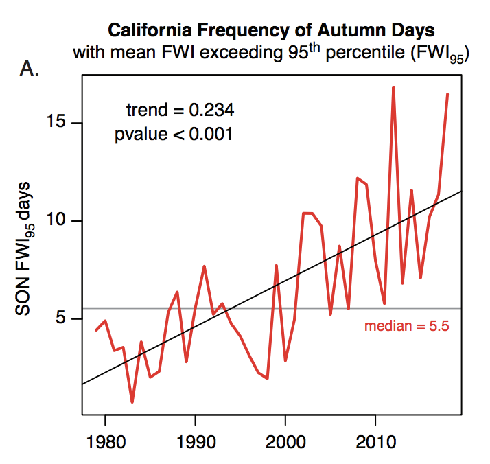
Record heat, plus late arrival of seasonal rains, have played a key role in CA's extremely severe wildfire seasons in recent years. Autumn 2020 exemplified this trend: vegetation conditions were, by a wide margin, the most flammable on record.#CAfireagupubs.onlinelibrary.wiley.com/doi/abs/10.102… (3)
PSA: Relatively low-latitude, even sub-tropical, locations in central & eastern portions (but less frequently western portions) of continents can occasionally experience severe winter cold spells--like Texas is currently enduring. But how, & why this longitudinal asymmetry?(1/17)
Well, water has a tremendous ability to buffer against thermal extremes. This is because H20 has high heat capacity--around 4x that of land! This means that it takes around 4 times as much energy to raise the temperature of a given mass of water the same amount as land. (2/17)
An intuitive consequence is that regions near large bodies of water are usually milder than landlocked areas at a similar latitude. This is also why dry places have much larger diurnal temperature ranges than humid places. (3/17)
Thread on very strong inbound CA storm. A cold & clear morning will quickly give way to increasing clouds, NorCal valley rain & snow down to 1,500-2,000 ft (locally lower) later this PM. Current satellite imagery shows this strengthening system off the coast. (1/10) #CAwx
Tonight, a rapidly intensifying cold front will sweep across NorCal. This front will be unusually well defined, for a CA winter storm, and will replace an already cold airmass with...another cold airmass! (2/10) #CAwx
The cold frontal passage is expected to be quite dramatic across NorCal in the overnight hours. A convective "narrow cold frontal rainband" (NCFR) will likely develop, which could bring a period of torrential rain or snow to many areas, as well as possible lightning. (3/10) #CAwx
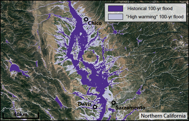
In case you missed it: a "thread of threads" highlighting some of our collaborative research from 2020. How are wildfires, atmospheric rivers, floods, and other extreme events changing in a warming #climate (and in California specifically)? Read on for details: (1/8) #CAwater
A general-audience primer on the rapidly advancing science of "extreme event attribution." How do scientists approach question of whether #ClimateChange is affecting likelihood and/or severity of extreme weather events? (2/8) @ClimateChirper@danielletouma
First, some good news: NorCal seems to have made through initial (extreme wind) phase of this critical fire weather event relatively unscathed. Few new small fires, but nothing unmanageable. A few thoughts as to why this was the case: #CAwx#CAfire
Very strong to extreme winds and exceptionally low humidity did materialize, despite an initial delay. A peak Bay Area gust of 89mph (with fairly widespread gusts above 50-60 mph), and peak Sierra Nevada gusts well over 100mph, were recorded. #CAwx#CAfire
In some spots, extreme winds did indeed mix down to low elevations (interior North Bay Valleys; Oakland Airport; San Francisco; Half Moon Bay). But some locations closer to sea level saw little wind,so sea level gusts were somewhat less widespread than initially anticipated.#CAwx
Folks: major wind/extreme low humidity/fire weather event is still coming--it just might be slightly delayed (by a couple hours or so in SF Bay Area). Very surprised to hear that PG&E is cancelling some of the planned PSPS with strong winds still inbound?? #CAwx#CAfire
Are @NWSBayArea or @NWSSacramento aware of any major forecast changes that would explain why PG&E is claiming that conditions will no longer justify a PSPS (at least in portions of East Bay Hills and Sierra foothills)? I certainly am not...