Historical hurricane analog for #Grace.. let's see if it'll drop further south in the Bay of Campeche 👀 ImageImage
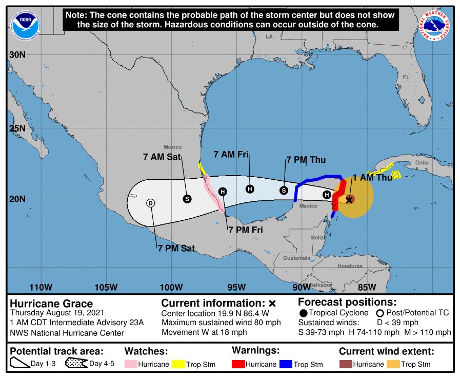
Update: #Grace has entered the Bay of Campeche.
Update: #Grace seems to be a tad too far north from the shore to replicate Hurricane Karl's case of TC-land interaction… there does not seems to be a vigorous coastal rainband to the south of #Grace at the moment. ImageImage
Overnight, however, we did see *some* convection developing along the S coast and robust upshear-wrapping cool cloud tops towards the NW at the same time that eventually formed the inner core of #Grace ✍️
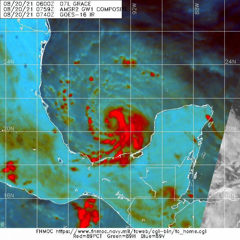
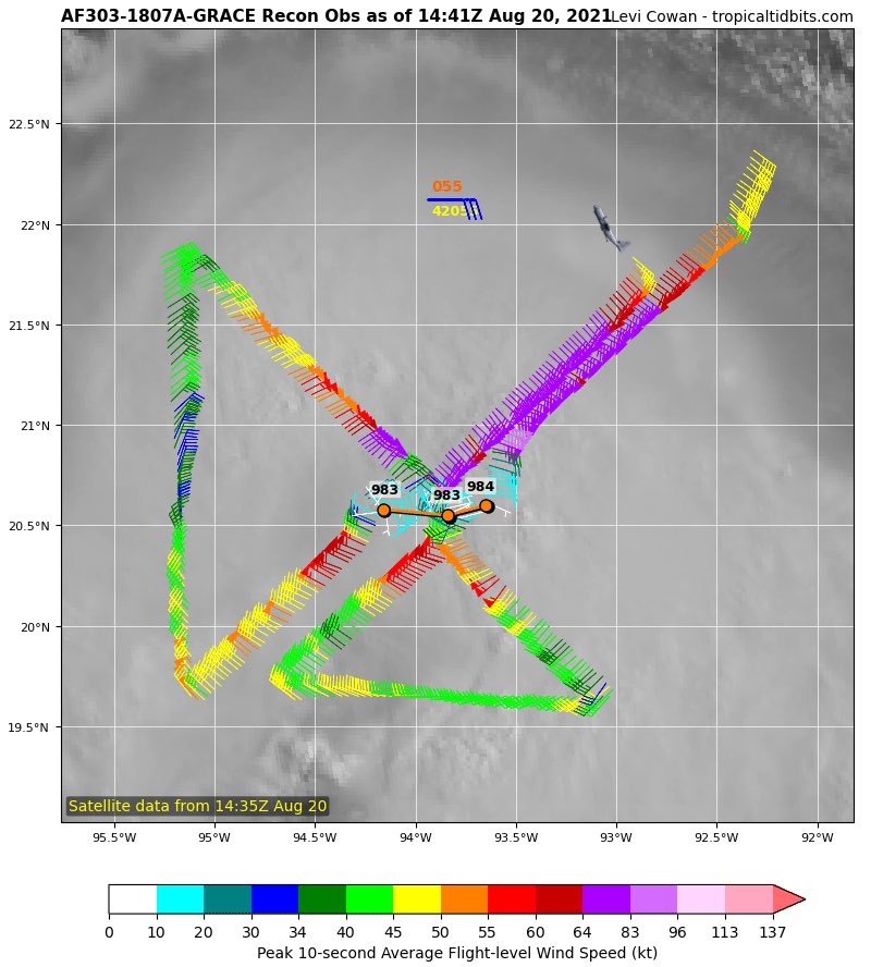
This morning's microwave scan showed #Grace had an eyewall in formation as well as a faint signature of "coastal rainband". Latest recon confirmed #Grace acquiring Cat. 1 strength with a minimum pressure around 983 hPa. ImageImage
The wrapping of #Grace's core continues, albeit running out of time soon as it'll face the higher mountains on the west Campeche coast that killed Karl (2010) almost upon contact.
Eye see you #Grace 🤤🤤🤤 Image
Soooo basically #Grace deepened 15 hPa in 10 hours since the morning pass and became a Cat.2, 85 kts / 967 hPa at sunset… or 27 hPa / 30 kts strengthening in past 24 hours. That would officially classify as rapid intensification! Image
Latest satellite loop shows a well-defined banding feature positioned along the coast to the west of #Grace with an eye trying to clearing out in the inner core.
Microwave scan also revealed a thick eastern eyewall in #Grace with vigorous convection. Image
Latest recon shows that #Grace may have reached its peak intensity and started to weaken, as its inner core is coming close to the mountainous terrain in central Mexico. ImageImage
115 kt FL / 105 kts SFMR winds in latest recon pass for #Grace! However, this does not necessarily signify further intensification - it could well be the PBL supergradient jet that developed as result of differential friction and terrain barrier. It's highly asymmetric. ImageImage
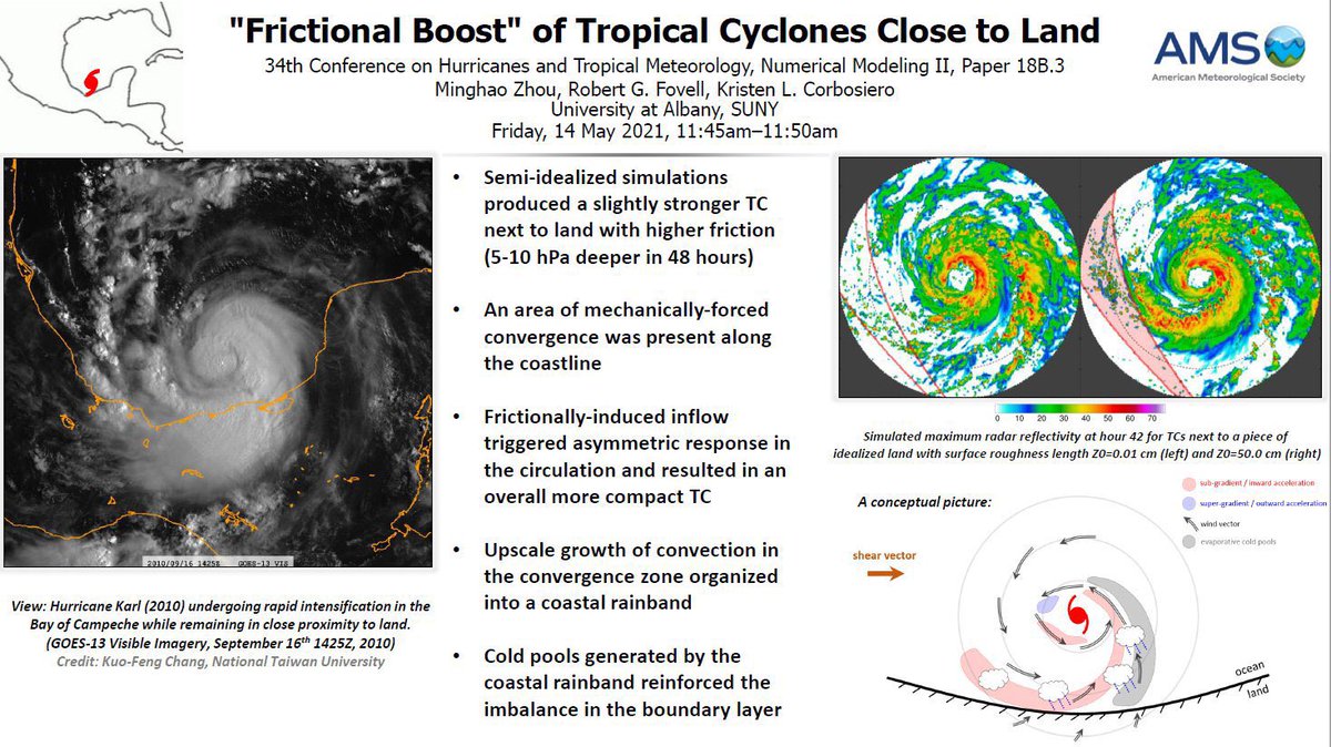
In my idealized simulation of a TC tracking parallel to the coast, an asymmetric inflow branch developed between the TC and the land, wrapping downwind to the mirroring side of the eyewall. This inflow surge (and coastal rainband) disappeared when friction over land was removed. ImageImageImageImage
Just in : NHC has upgraded #Grace to a Cat. 3 hurricane with 105 kts maximum winds and 967 hPa minimum pressure. This makes #Grace the first major hurricane and strongest hurricane so far of the 2021 season.
#Grace did it! What an overachiever. Proudly my Campeche storm!! 🙇‍♂️ Image
Meanwhile, satellite performance of #Grace has been steadily deteriorating, despite terrific major hurricane winds sampled in E eyewall. Core is being interrupted by asymmetric inflow caused by land interaction, and the IR eye would never have a chance to clear out... Bye, Grace!
NHC further adjusted #Grace to be an 110 kt / 962 hPa upper-tier Cat.3 hurricane just prior to landfall. Not sure what's the rationale besides perhaps the last impressive dropsonde in NE eyewall & trend extrapolation? I haven't found any buoy or central Mexico obs at the moment.. Image
Achieved content: GeoColor satellite loop of #Grace crossing the Bay of Campeche and some serious Déjà vu for me.
Archived content: Band 13 (clean IR window) satellite loop of #Grace passing the Bay of Campeche in 30 hours.
Archived content: Band 16 (longwave IR for tropopause-visual enhancement) satellite loop for #Grace in the Bay of Campeche. Legendary.

• • •

Missing some Tweet in this thread? You can try to force a refresh
 

Keep Current with Minghao Zhou

Minghao Zhou Profile picture

Stay in touch and get notified when new unrolls are available from this author!

Read all threads

This Thread may be Removed Anytime!

PDF

Twitter may remove this content at anytime! Save it as PDF for later use!

Try unrolling a thread yourself!

how to unroll video
  1. Follow @ThreadReaderApp to mention us!

  2. From a Twitter thread mention us with a keyword "unroll"
@threadreaderapp unroll

Practice here first or read more on our help page!

More from @Minghao_Zhou

21 Aug
Cover story of today: #Henri has been "hooked" up by an upper-level cutoff low over the eastern US and started to accelerate north, "starburst" outflow pattern heralds a last chance for intensification.
Earlier this morning, the Central Cold Cover (CCC) having trapped #Henri for so long finally came to dissipation. As upper-level SW winds from the cutoff flushed toward #Henri and (briefly) mitigated shear problem, the storm took on new appearance and started to form a real core.
Morning recon into #Henri revealed the inconvenient facts that the storm, shabby and mediocre, barely holds on as a "hurricane" despite more than a day's very deep yet asymmetric convection. NW quadrant was astoundingly weak. But now, things are wrapping up and being compensated.
Read 8 tweets
20 Aug
The persistent & very cold cloud tops in #Henri is actually a dubious sign and bad news. In fact, #Henri may have been plagued with such pattern and have halted intensification. 1/n
The Dvorak TC analysis technique may refer to such phenomenon as the development of a "Central Cold Cover", or CCC. It's characterized by persistent and enormously large cirrus canopy coverage with no well-defined curved bands or eye appearance.
My personal understanding: CCC is usually linked with large vertical wind shear. Think about a gigantic MCS over the ocean - that's a steadily tilted TC in strong shear, moving slowly over warm waters, with all asymmetric convection locked in space. #Henri is in 20+ kt of shear.
Read 10 tweets
20 Aug
#Henri (learned today that it's not supposed to be pronounced as "Henry) currently still has its outflow blocked by upper-level NE winds. It can be seen from the loop that the low-level cloud curvatures are out to the NW while upper-level circulation center is tilted to the SE…
In sketch terms:
From the GFS forecast, it seems that the poleward outflow channel won't open up for #Henri until Friday PM hours and so is a window for faster intensification.
Read 7 tweets
21 Jul
Archived content: sketch of how extreme rainfall in Zhengzhou, China was related to (1) moisture transport enhanced by the monsoon gyre, (2) deepening upper-level trough, and (3) leeward inverted trough and upslope flow. 1/n
#Henan province has seen 837 stations with 24 hour rainfall amount of 100mm+ (~4"+), 195 stations above 250mm+ (~10"+), with the bullseye centered over the state capital of #Zhengzhou, which was submerged under widespread 400~600mm totals.
Maximum hourly rain rate observed at #Zhengzhou was a staggering 201.9mm between 4-5pm local time. This is a new record for all 2418 national stations in mainland China and possibly the largest downpour in human history for a city with 10+ million population.
Read 6 tweets
20 Jul
ECMWF ensembles showing the Fujiwhara effect between Typhoon #Cempaka 🌼 and Typhoon #Infa 🎆 as the two storms were forecasted to move around each other 🌀
That is one big monsoon gyre circulation over the northwest Pacific, formed by converging easterly trade winds and westerly monsoons. It gave birth to #Cempaka and #Infa. It might give birth to more typhoons.
Typhoon #In-fa has an eye in formation this morning (meaning: "fireworks" in Cantonese 🎆 name origin: Macao). Improving structure despite some dry air issues. #In-fa is forecasted to detach from its monsoon "tail" and continue to intensify while moving towards Taiwan.
Read 4 tweets
19 Jul
Typhoon #Cempaka rapidly intensifying while drifting slowly offshore of Guangdong Province, China (#Cempaka name meaning: a type of tree with fragrant flowers 🌼 name origin: Malaysia)
#Cempaka has reached 65 kts, 977 hPa per JTWC and 38 m/s, 965 hPa per CMA, despite initial expectations to remain a tropical storm. The land-sea surface friction contrast has caused #Cempaka's most intense convection to locate in the SW quadrant with a slightly elliptic eye. Image
My idealized simulations showed the predictable patterns of such asymmetry induced by friction, and their possible contributions to near-shore intensification of TCs👇 Image
Read 4 tweets

Did Thread Reader help you today?

Support us! We are indie developers!


This site is made by just two indie developers on a laptop doing marketing, support and development! Read more about the story.

Become a Premium Member ($3/month or $30/year) and get exclusive features!

Become Premium

Too expensive? Make a small donation by buying us coffee ($5) or help with server cost ($10)

Donate via Paypal Become our Patreon

Thank you for your support!

Follow Us on Twitter!

:(