1. Previously I provided plots and threads of Lakes Mead and Powell contents separately. This short thread deals with the combined contents of both reservoirs and projections out to Aug 2023. The combined contents provides a complete view of the problem. #coriver #ClimateCrisis
2. This shows the combined contents back to 1935 when only Mead existed. In 1963 Lake Powell begins to fill. By 1983 the two are totally full -- even over full for a bit as Lake Powell had temp plywood boards installed to prevent downstream flooding.
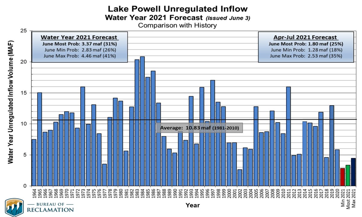
3. By next year the combined contents will be below 30%, less than some years when only Mead existed before 1963. And the minimum probable projections put the contents around 20% (10 maf total) in 2023.
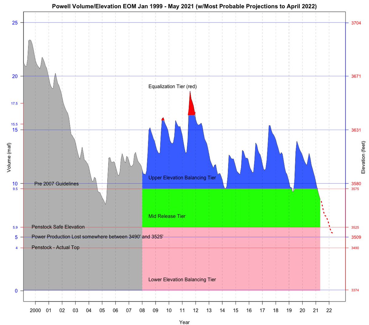
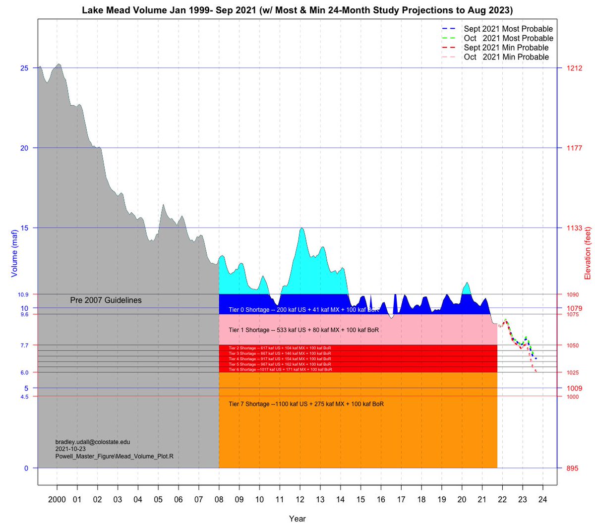
4. This is the same data, only starts in 1999. (Sharp-eyed readers will note that I re-normed the % full to 49.5 maf=100% from prior versions.)
5. Since 2000, with the exception of 2011, the system has either gone down, or stayed the same during the 22-year period. (And note that 2012-2013 quickly wiped out 2011 gains.)
6. There are 3 notable periods when major storage declines happened: 2000-2004, 2012-2013, and now 2020-2021. Declines are due to a combination of low flows and demands that exceed those low flows.
7. We are now entering a period where our risk of emptying these two reservoirs is much higher simply because we have less stored water -- somewhere between 15 maf today and perhaps 10 maf by 2023.
8. I shouldn't have to say it but I will:

Emptying reservoirs upon which Phoenix, Tucson, Los Angeles, San Diego and Las Vegas depend is not an option. Many acres of nationally important irrigated ag rely on this water, too.
9. Mitigating this risk of additional declines are the plans put in place to reduce demands by up to 1.4 maf/year thru the 2007 Interim Guidelines and the 2019 DCP. But Mead has to lose about another ~ 3maf for the full demand reductions to occur.
10. If these demand reductions plans are the equivalent of a parachute, there are legitimate questions about (a) the size of the parachute and (b) why are we deploying it so close to the ground given all that has transpired over the last 22 years. END

• • •

Missing some Tweet in this thread? You can try to force a refresh
 

Keep Current with Brad Udall

Brad Udall Profile picture

Stay in touch and get notified when new unrolls are available from this author!

Read all threads

This Thread may be Removed Anytime!

PDF

Twitter may remove this content at anytime! Save it as PDF for later use!

Try unrolling a thread yourself!

how to unroll video
  1. Follow @ThreadReaderApp to mention us!

  2. From a Twitter thread mention us with a keyword "unroll"
@threadreaderapp unroll

Practice here first or read more on our help page!

More from @bradudall

22 Oct
1. Here are the 24 month Lake Powell projections to Aug 2023. Both last month (Sep) and this month (Oct) projections are shown for "minimum probable" and "most probable". #coriver #climatechange @R_EricKuhn @jfleck
2. The Min Probable projections for both Sep and Oct are well below safe minimum power elevation of 3525 for most of the projections and even below the top of the penstocks at 3490 for some time.
3. The Most Prob projections for Sep and Oct keep Powell in reduced releases to Lake Mead, 7.48 maf, thus ensuring Mead also drops.
Read 8 tweets
5 Oct
A 2nd thread on Lake Powell from this weekend. See earlier thread for Tweets 1-14.
/15 Here's the bottom of the Wahweap Stateline ramp, now closed.
/16 This is the recently opened Stateline replacement ramp. It opened just days ago.
Read 10 tweets
5 Oct
/1 I spent the weekend looking at various locations on Lake Powell. A short thread follows on what I saw and my impressions. Lake Powell is the 2nd largest reservoir in the US. Since 2000 flows in #ColoradoRiver are down by 20%, half due to #climatechange.
/2 Here's a look at Powell contents since 2000. We're at 3545 (right axis) now, about 7 maf out of 25 maf possible. It is stunning how low the lake is.
/3 I visited Bullfrog Marina, the overlook that shows Hite Marina and the river now down cutting through 50-year-old lake sediments, the new Cataract Canyon takeout, Wahweap Marina, Glen Canyon Dam, and Antelope Point Marina.
Read 14 tweets
8 Jul
2. Reclamation’s ‘unregulated inflows’ into Lake Powell show that 2021 will be the 2nd worst year after only 2002 going back to 1964. 2021 will be the RED bar most likely. This is a really grim year for runoff.
3. 2021 Inflow will be only ~3 maf, compared to the 1981-2010 average of 10.3 maf or the 2000-2021 average of 8.3 maf (20% less than 1981-2010 average).
(maf = million acrefeet)
4. Considering that Powell will release / evap ~ 8.5 maf, the lake will lose ~ 5 maf this year or ~55 feet of elevation.
Read 19 tweets

Did Thread Reader help you today?

Support us! We are indie developers!


This site is made by just two indie developers on a laptop doing marketing, support and development! Read more about the story.

Become a Premium Member ($3/month or $30/year) and get exclusive features!

Become Premium

Too expensive? Make a small donation by buying us coffee ($5) or help with server cost ($10)

Donate via Paypal Become our Patreon

Thank you for your support!

Follow Us on Twitter!

:(