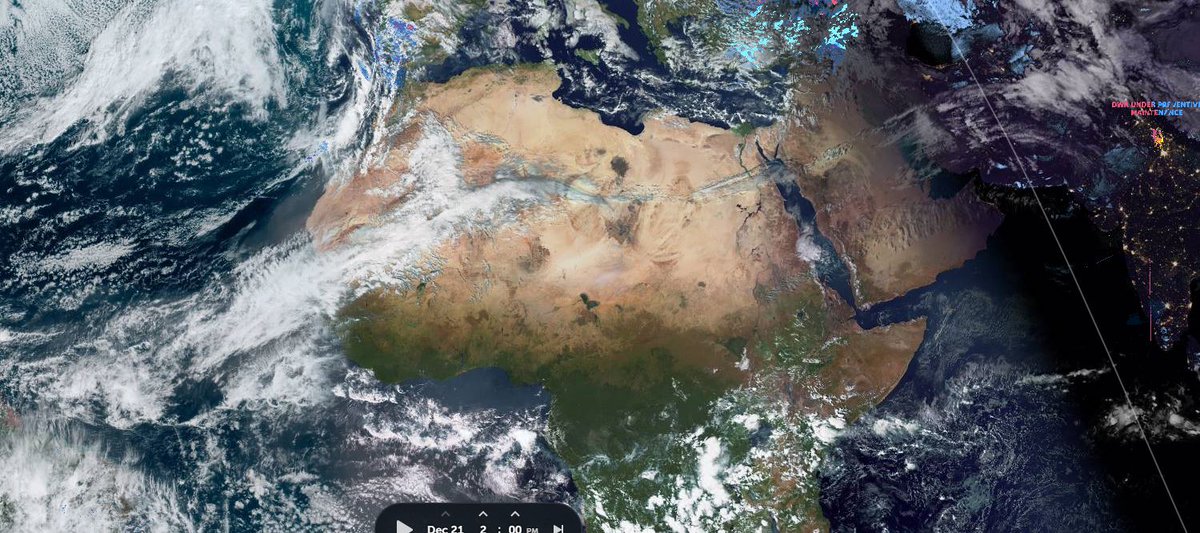
This is the most colossal Saharan #desertrain event I have ever observed and It is set to have significant impacts soon in the Middle East.
Here's a zero hour weather model plot of those winds which shows that the rain is originating in the Tropical Atlantic and the great Amazon forest's monsoon. 

The next set of graphics are from @meteoblue and show satellite weather radar estimates of where rain is falling and its intensity. These images begin on the 20th of December, where you can see intense convection over the Atlantic supercharging the event. 


Here we can see some of that convection.
These images show development of the #DesertRain impact area in the center of the Great Saharan Desert yesterday. 


And here we see it today with some measurements superimposed on the @zoom_earth imagery. 


And an animation of the last 24 hours. The leading edge of this will likely reach Egypt tomorrow.
Yesterday and overnight on the 20th the impacts of this water transport event in the ME were significant. This provides an over view of the same 24 hours above, but further east centered over Egypt.
Here's a closeup of the storms over Saudi Arabia and the Gulf on the night of the 20th.
And here's the picture over the Levant overnight yesterday into this morning.
Looking at rainfall today. Here we see snapshots of satellite inferred rainfall over the Sahara at 12pm 3pm and 6pm and 7.45pm AST/EAT. 


Scale wise these images show measurements of the cloud area at the front of the plume at midday and 6pm CEST (2pm and 8pm EAT). These areas are respectively 1.6 and 2.6 times the size of France. 


Some weather observations from @Arab_Storms
1. Umm al-Fahm, Northern Israel.
1. Umm al-Fahm, Northern Israel.
https://twitter.com/Arab_Storms/status/1473551006982103043?s=20

2. A water spout off the coast of Turkey.
https://twitter.com/Arab_Storms/status/1473389417234640907?s=20
3. A rain storm during a soccer match in Syria.
https://twitter.com/Arab_Storms/status/1473185789014159362?s=20
This GEFS PWAT anomaly provides a rough guide to where atmospheric water is in unusually high volume over 270 hours from December 20th.
And this GFS1Hrl model Jet Stream simulation provides us with a 16 day forecast of what's happening to the winds that are carrying the moisture eastwards. While the winds weaken a little they resume on the same trajectory as now at a similar intensity.
That previous jetstream animation also shows us that there is a nasty storm brewing in the North Atlantic. Here we see lower altitude wind intensity.
And here we see a 16-day forecast of water/energy in the Middle East.
Which according to the latest GFS model run results in this accumulating rainfall result.
NOTE: This ME rainfall forecast is unlike anything I have ever seen. And typically from what I have seen the GFS underplays rainfall forecasts in the middle east.
@Arab_Storms
NOTE: This ME rainfall forecast is unlike anything I have ever seen. And typically from what I have seen the GFS underplays rainfall forecasts in the middle east.
@Arab_Storms
• • •
Missing some Tweet in this thread? You can try to
force a refresh


