Local Weather 1) Decreasing clouds today with temps rising into the mid to upper 40s this afternoon. Cold and dry Tues/Wed. Low 23 High 40, low 23 on Tues. Low 20 High 49 on Wed. As a disturbance move east, it will go negatively tilted Thursday and spawn low pressure development
2) Off the Carolinas coast. I have been watching this all weekend, but for now it looks to stay far enough offshore to only bring some showers to the immediate coastal areas. For now, P. Cloudy for RDU, Thurs: High 54, Low 29. P. Cloudy Friday: High 49, Low 31.
3) Sat looks dry, High 43, Low 26. We will need to watch a system behind the prev storm which could dive further S, thanks to the previous storm blowing up off the NE coast. If it can dig far enough south and tap Gulf moisture we could see wintry weather here Sunday.
4) Yesterdays 12z ECMWF was a pretty significant system. The 00z ECMWF was flatter/weaker and a bit further south, but still impactful and there is decent support from the 00z EPS members (06z EPS mean and 00z EPS members shown). The 00z UKMET at day 6-7 also shows it. ImageImageImage
5) 00z GFS showed enough digging to bring some light snow, the 06z GFS keyed more on the s/w behind it and and just brought light rain to the coast Mon. The 00z CMC didnt dig the s/w far enough south and we saw more of a basic frontal passage with rain. Which scenario is right?
6) Right now, I favor the ECMWF/EPS/UKMET solution, but lets see if we can get one more run today at 12z to support it. There is some support from the 06z GEFS as well. For now, something to watch for Sunday time frame but not honk for quite yet.
7) Decreasing clouds Monday, Temps will depend to an extend to what happens the day before. For now, I will go with high of 45, low of 28. It looks dry thru Wednesday with colder than normal temps. Highs in the mid 40s lows in the upper 20s to near 30.
8) Another time frame to watch is the 1/20-1/21 time frame. The ensemble members show some support for a wintry threat then, the operational models have been all over the place, so no solid feel yet but a time to watch.
9) The pattern in the 1/20-1/24 time frame will continue to feature strong ridging in the GOA and a trough over southern Canada and the central and eastern US. The EPS wants to start to build the SE ridge by 1/25, but the GEFS/GEPS dont yet. ImageImageImage
10) The 5 day 2m T anomaly is below. We could see some big cold in the Upper Midwest/Lakes. The models arent showing as big a threat for a plunge of this south/east today, keeping the coldest air w.r.t normal over the Midwest. But still a cold pattern and one to watch. ImageImage
11) I still think we turn warmer by the very end of Jan and Feb. The GEFS-ext, CFS-weeklies, and EPS-weeklies show this. The MJO loitering in phase 7 also supports this look in Feb. For now, we wait to see if that starts consistently showing late in the ensemble runs. ImageImage

• • •

Missing some Tweet in this thread? You can try to force a refresh
 

Keep Current with Allan Huffman

Allan Huffman Profile picture

Stay in touch and get notified when new unrolls are available from this author!

Read all threads

This Thread may be Removed Anytime!

PDF

Twitter may remove this content at anytime! Save it as PDF for later use!

Try unrolling a thread yourself!

how to unroll video
  1. Follow @ThreadReaderApp to mention us!

  2. From a Twitter thread mention us with a keyword "unroll"
@threadreaderapp unroll

Practice here first or read more on our help page!

More from @RaleighWx

12 Jan
1) So a look at where we stand now I posted this earlier but you can see that over the last 10 runs the GFS has trended the main disturbance W/SW from OH to OK This allows for less confluence over the NE (cold high pressure) and earlier strengthening/amplification of the main s/w
2) The result is that the GFS now take the primary low into Kentucky, not AL/MS and miller B secondary cyclogensis occurs over the NC coastal plain not off the SC coast. The 6z GFS shown This scenario causes a changeover for most east of the mtns Big snow for The apps/interior NE
3) The GEFS (GFS Ensemble) mean has been consistently further south/east (less ampified). The 6z run still is BUT it trended more towards the op GFS. Look at the low placements now vs the 00z run. More members over the NC coastal plain not offshore. I.e trending towards op GFS.
Read 11 tweets
11 Jan
1) I looked at the individual EPS members at 12z. And grouped them into 3 scenarios. Op model idea (close to coast or inland track), ENS mean idea (offshore track), and other which is mostly a really suppressed track. I came up with Group 1: 21 Group 2: 22 Group 3: 7 #snow
2) I think this is a better way to look at the ensemble to see what scenario is favored. For now, it is 50:50 mostly with the outside chance we have a much more suppressed solution. I will try and update this each cycle to see how we trend.
3) Same exercise with the 12z GEFS. The GEFS had more scenarios though. The original 3, but option 4 (Slider) as the surface low move ENE out to sea south of Hatteras. And the 5th a more NW flow event with the northern stream dominant, similar to yesterday. I came up with:
Read 5 tweets
11 Jan
Local Weather Summary 1) Sunny and cool today and Wednesday. High around 41 today, low tonight in the low 20s. High Wed around 51. Some increasing clouds Thursday as a disturbance moves towards the area. High 55, low 28.
2) This disturbance could bring a shower or perhaps even a snowflake mixed in late Thursday night. But it will be dry for many and temps in the upper 30s will likely mean all rain for most. But I cant rule out a stray flake. This disturbance will form a strong low off the coast.
3) It will stay out to sea, but will help the system behind it that will bring our winter storm threat dig towards the Gulf coast. Friday should be Partly Cloudy with a high near 50.
Read 6 tweets
11 Jan
1) So for this weekend storm. Right now, to me it looks to have 3 potential paths. 1. The GFS/CMC path which is that there is enough separation between the storm ahead and disturbance behind that the s/w cuts off and becomes neg titled This leads to the big storm idea GFS/CMC
2) Path 2, favored by the ECMWF/UKMET Is that the shortwave cant become neutral or negatively but is positively tilted This is a weaker, flatter, further south scenario Significant strengthening is slower and off shore. This could still bring wintry weather to the South, but less
3) Path 3 not shown, but still possible is that the northern stream is stronger and we see more of a strong clipper/low pressure type event, like yesterdays models implied. This would still bring some snow, but with less Gulf/Atlantic moisture involved and focused more on NC/VA
Read 6 tweets
21 Sep 21
Local Weather 1) rain is likely the next couple of days with a general 1-3 inches for many. Some areas of the foothills/NW piedmont and SE NC could see 3-5 inches of rain locally.
2) After the front passes Wed night/Thurs am we see a dry, less humid and cooler weather pattern. Morning lows will be in the 40s in the west and low 50s in the Triangle Friday/Saturday with highs in the mid 70s. Sunday looks nice as well making a wonderful weather weekend.
3) Next week temps warm a bit back into the upper 70s to low 80s. Rain chances remain low but could increase slightly for mid week.
Read 4 tweets
2 Aug 20
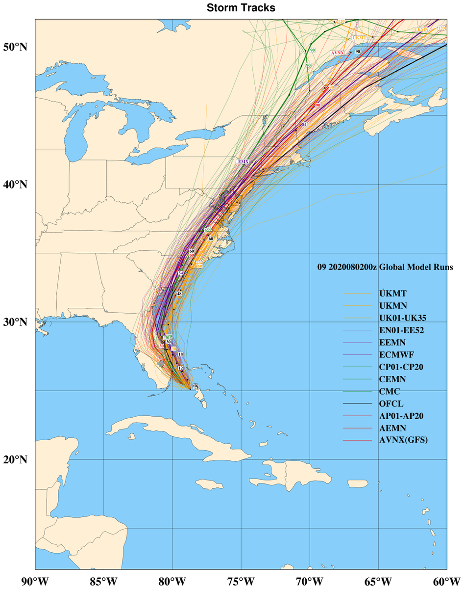
Here are the major 00z global models and their ensembles. #Isaias will likely stay just off the SE FL coast, although a brief landfall of the center still cant be ruled out. I think landfall will likely be between Cape Romain SC and Cape Fear, NC. I have shifted my track (1/4)
a bit west with landfall of #Isaias near the NC/SC border, I am still a bit NE of the model consensus at the moment. With a track up the NC coastal plain, Tidewater/Delmarva/NE Coast. It does looks more likely that the center will stay mostly onshore on its ride NE. (2/4)
As far as intensity. #Isaias has not been a easy storm to forecast intensity wise. I would imagine little strengthening today as it is close to the coast. There could be a window to re-attain cat 1 strength tomorrow over the ocean before landfall Monday night. (3/4)
Read 4 tweets

Did Thread Reader help you today?

Support us! We are indie developers!


This site is made by just two indie developers on a laptop doing marketing, support and development! Read more about the story.

Become a Premium Member ($3/month or $30/year) and get exclusive features!

Become Premium

Too expensive? Make a small donation by buying us coffee ($5) or help with server cost ($10)

Donate via Paypal

Or Donate anonymously using crypto!

Ethereum

0xfe58350B80634f60Fa6Dc149a72b4DFbc17D341E copy

Bitcoin

3ATGMxNzCUFzxpMCHL5sWSt4DVtS8UqXpi copy

Thank you for your support!

Follow Us on Twitter!

:(