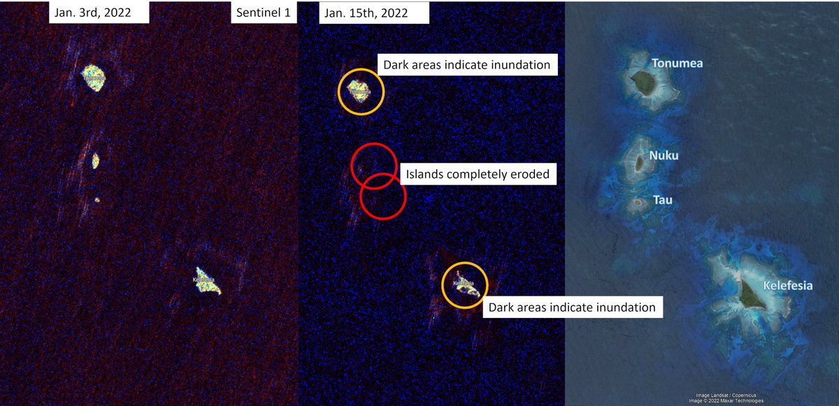
Satellite imagery reveals first losses due to the #Tonga#tsunami.
It seems that the uninhabited islands of Nuku and Tau have been completely eroded. Their larger neighbors Tonumea and Kelefesia were at least partially inundated.
@sentinel_hub Nomuka island , North of #Tonga was also significantly affected. Its barrier islands Nomuka Iki was at least partially inundated and traces of inundation seem visible for the main town of Nomuka (400-500 people).
Interpretation is difficult.
A few more islands show traces of inundation. Unfortunately, there is not yet much data available to assess more regions.
Waiting for imagery for Nuku'alofa and the islands of Fiji.
• • •
Missing some Tweet in this thread? You can try to
force a refresh
"Seismische Ereignisse wollen wir auf jeden Fall vermeiden"
Etwas unglücklich formuliert im Kontext von (Tiefen)Geothermie. Denn solche "Ereignisse" gehören zum Verfahren einfach dazu - also sog. Mikrobeben. Zu vermeiden sind seism. Ereignisse mit Schäden. bnn.de/nachrichten/ba…
Berichterstattung zeigt einen gewissen monetären Bias. 4 Artikel zum Thema #Tiefengeothermie. 3 mit neutral bzw. positiver Tonalität sind hinter der Paywall. Der einzige kostenlose ist jener mit deutlich negativer Tonalität.
Die meisten Leser werden nur letzteren sehen. #BNN
Unabhängig davon was man von Tiefengeothermie hält, auch ich habe einige Bedenken (aber auch Hoffnungen), so finde ich gerade bei so einem öffentlich aufgeheiztem Thema eine ausgewogene Berichterstattung wichtig.
Aber ist Kernenergie oder Windkraft oft nicht anders.
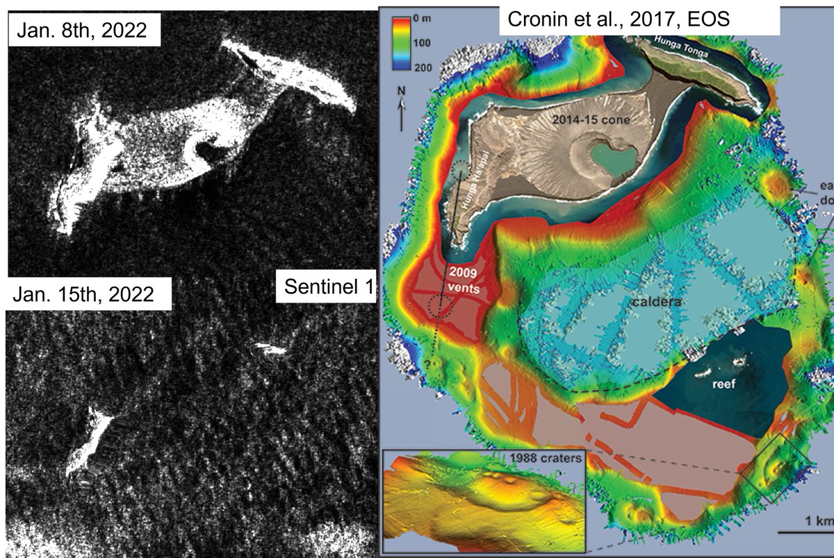
With latest satellite imagery, we get a step closer to understand what happen with Hunga #Tonga leading to this ocean-wide #tsunami.
Latest @sentinel_hub imagery shows the loss of a majority of the volcano's emerged landmass. However, most of its structure lies underwater.
Assuming that most of the volcanic dome was still intact prior to the main eruption, an area of about 2.5 km² was lost. With a height of 150-200m, we can assume that about 0.5 km³ of mass might has been moved.
If parts of the caldera have collapsed it might be much more.
Some parts of the volcano had already drowned during yesterday's (Jan 14th) eruption. As shown by satellite imagery from @planet taken just about 2h before the main eruption.
Genug #Tsunami für mich für heute.
Status von #Tonga weiterhin unklar.
Wellenhöhen für Korallen- und Tasmansee passen zu Simulationen. Beständige Wellenhöhen (~1m) in
großer Distanz. #California und #Japan werfen jedoch Fragen auf. Dafür zu niedrig auf #Samoa & #Fiji.
Vermutung liegt auf teilweise oder vollständigem #Caldera collapse.
Eventuell erst partieller Hangrutsch, danach Kollaps (beides weitestgehend unter Wasser).
Klare Daten kann man erst in Tagen erwarten.
Bekannt ist, dass es auf vielen Inseln im näheren Umfeld zu Schäden gekommen ist, teilweise aber in 1000en Kilometern Entfernung. Gerade letzteres braucht umfassende Analyse.
Normalerweise verlieren derartige Wellen schnell an Energie, außer sie sind besonders ausgedehnt.
This simulation might be an underestimation (1km resolution, unclear source mechanism -> volcano collapse/landslide, 2km³)
It can not adequately reflect complex wave patterns near the coasts.
Observations so far:
Apia, Western Samoa: 0.3m
North Cape, NZ: 0.5m
Suva, Fiji: 0.5m
Gold Coast, Australia: 0.8m
Port Vila, Vanuatu: 1.0m
Norfolk Island, Australia: 1.0m
Pago-Pago, American Samoa: 1.0m
Ouinne, New Caledonia: 1.5m
Raoul Island, NZ: 2.0m
Nukualofa, Tonga: >2m
Right now, the observed wave heights (tweet above) are not completely reflected by my simulation (but many at least).
I will keep enhancing the current simulation results.
There are still waves coming in, e.g. for Australia & New Zealand, which are higher than initial waves.
A major volcanic eruption resulted in a #tsunami offshore #Tonga, reports from there are scarce, but I tried to estimate the tsunami pattern due to the potential dome collapse of Hunga Tonga-Hunga Haʻapai #volcano
The simulation estimates the tsunami triggering via a sliding mass of up to 2 km³ volume. It might be an overestimation, but data is still coming in.
First eye witness reports/videos from Tonga already indicate major inundation for #Tonga
We have reports of waves +/- 0.5 - 1.5m from Samoa, Fiji, New Caledonia, Norfolk Island, even Australia and many more places.
Currently working on a simulation for the farfield effects. But calculation takes a while.
Manchmal, da bin ich froh, dass ich mich hauptsächlich mit Erdbeben und Tsunamis auseinandersetze.
Denn akutes menschliches Versagen ist hier im Vergleich zu Corona oder dem Klimawandel meist nicht ausschlaggebend.
Ein kleiner Risiko-Thread
1/10
Wenn sich Erdbeben und (oft in der Folge) Tsunamis ereignen, geschieht dies plötzlich und ohne Vorankündigung.
Trotz manchmal anderslautender Hypothesen ist eine Vorhersage von Erdbeben nicht möglich. Wir können lediglich Wahrscheinlichkeiten angeben.
2/10
Bei diesen Katastrophen, können wir nicht anders als lange im voraus zu planen. Zum Beispiel Strengere Vorschriften beim Gebäudebau verfassen die Bevölkerung sensibilisieren, Küstenschutzmaßnahmen ergreifen und vieles.