Short #Thread:

Though heavy rainfall is the trigger, our construction practices of where and how are the biggest causes behind some of the most devastating landslides that are costing both lives and money for us.

1/n
Image shows a relatively well vegetated hill slope in #Manipur in 2009
2/n
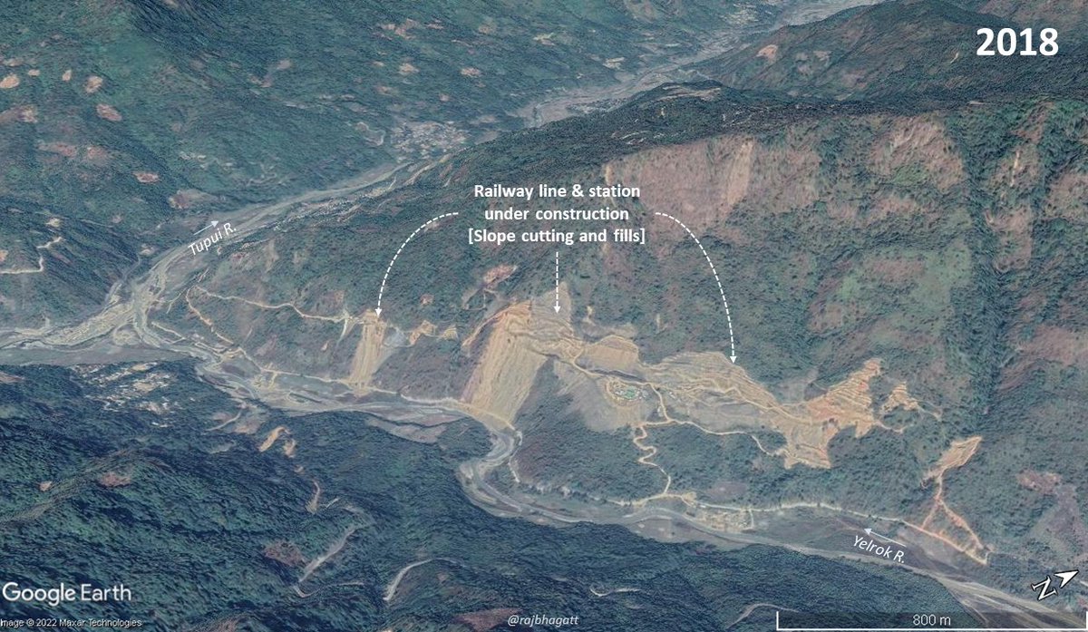
When a railway line was built along the slope (alongwith many roads), lots of slope cutting, vegetation clearances took place in the region.

3/n
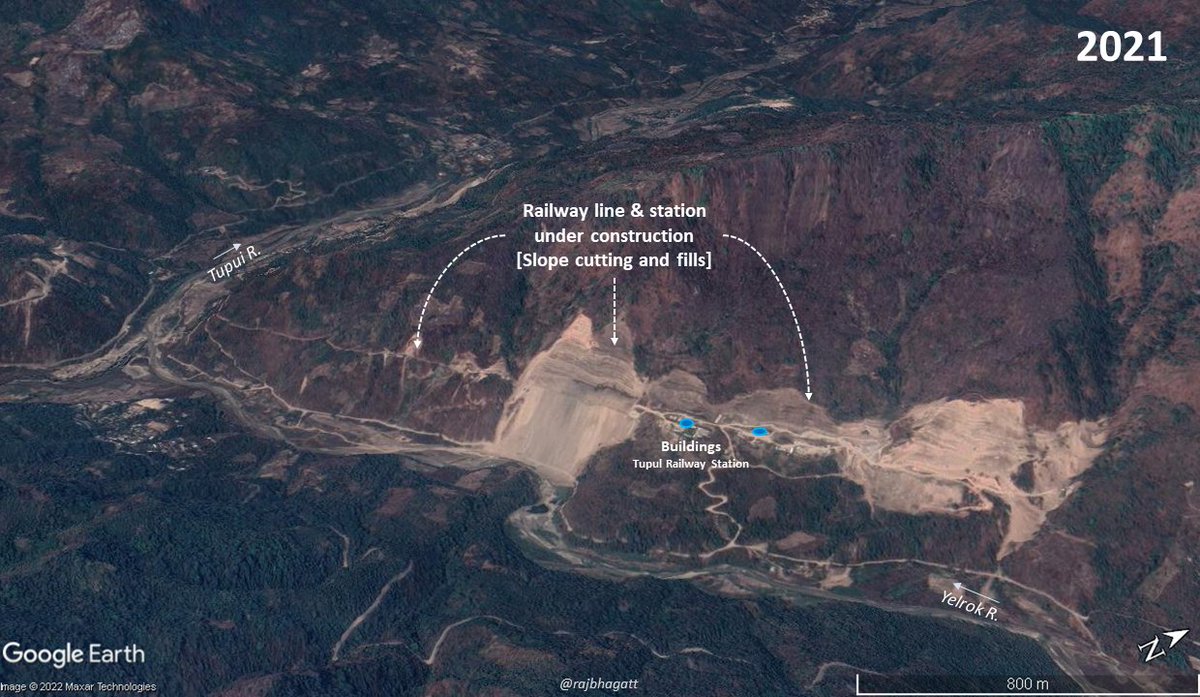
And the construction continued..

4/n
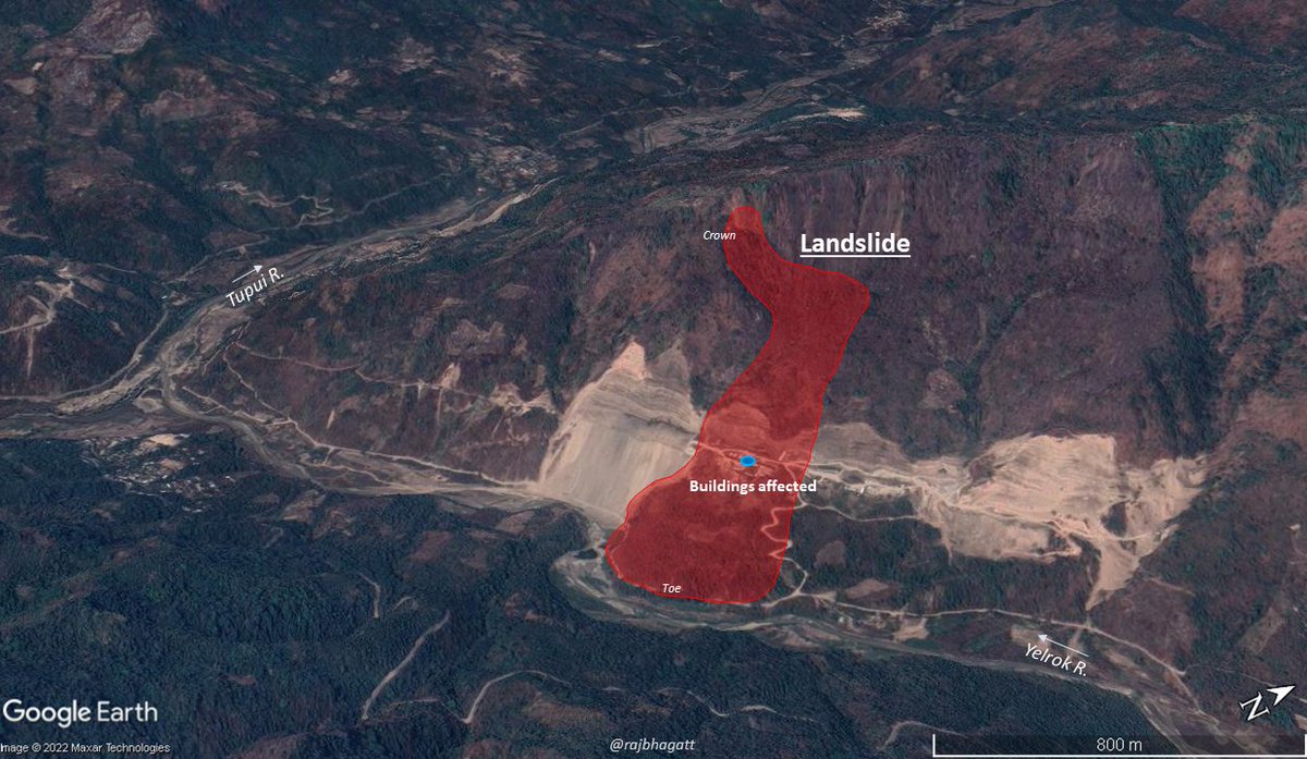
So when heavy rainfall happened, the slope failed creating a landslide with many people dead

5/n
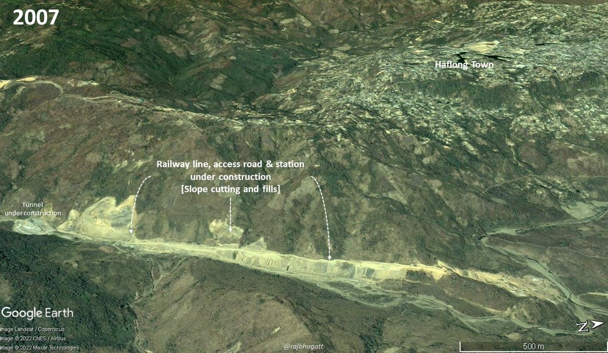
Similar case: New Haflong station in #Assam
Slope cutting for both the railway line and the access roads were done.

6/n
And then resulted in landslides when the place received heavy rainfall

7/n
One should note that, it is not just the slope cutting that is a problem but also with the narrow box culverts that are provided for side streams. IMO these are extremely small & would get choked which would destabilize the land above & would also overflow

8/n
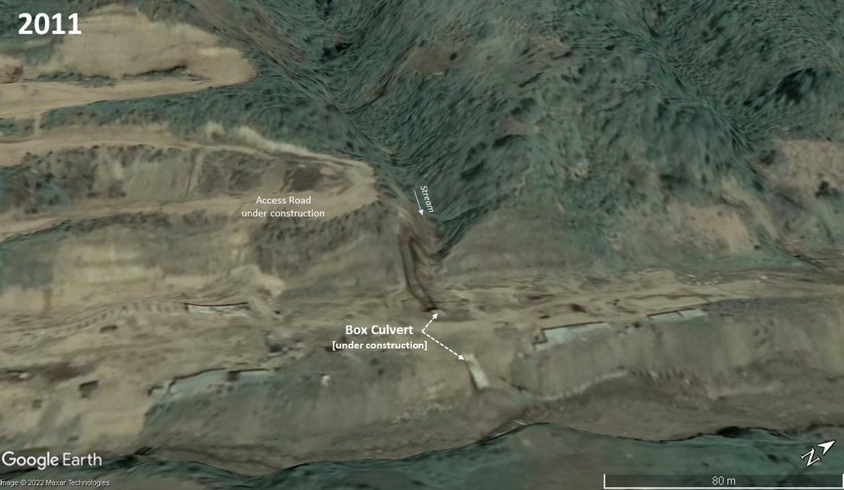
And also retaining walls of this size wont work in these situations anyway.
Unless we change our construction practices of where we build & how we build with respect to slope cutting, vegetation clearance, retaining walls & most importantly culverts for streams, we would continue facing devastating landslides. It wud be another place, another time

End

• • •

Missing some Tweet in this thread? You can try to force a refresh
 

Keep Current with Raj Bhagat P #Mapper4Life

Raj Bhagat P #Mapper4Life Profile picture

Stay in touch and get notified when new unrolls are available from this author!

Read all threads

This Thread may be Removed Anytime!

PDF

Twitter may remove this content at anytime! Save it as PDF for later use!

Try unrolling a thread yourself!

how to unroll video
  1. Follow @ThreadReaderApp to mention us!

  2. From a Twitter thread mention us with a keyword "unroll"
@threadreaderapp unroll

Practice here first or read more on our help page!

More from @rajbhagatt

Jun 11
Short #Story of a river, a sea, a fishing village, and a groyne

Satellite image from 2005 shows the delta of Porunai river (Thamirabarani) in Thoothukudi district of Tamil Nadu.

1/n Image
The river settled some amount of sand in the sea and close to the mouths the sea was shallower and with lots of sand.

2/n Image
A village (Punnaikayal) was dependent on this onfluence of the river and the sea but the fishing boats had difficulty in moving particularly during low tides

3/n Image
Read 10 tweets
May 16
#Thread:

#Visualization shows ownership of Cars, Bicyle, Two wheelers and also the households that dont own any of these

Why is this critical to know?

Prepared by @PratapVardhan @Stats_of_India
h/t @indiainpixels
Before going into the thread, let us clarify about the data. The data is an end product of a survey which surveyed around ~6,40,000 households across India

Data represented in this viz are aggregated at state level so rural-urban or other geo nuances might be hidden

2/n
Also they indicate ownership of vehicles and it would not truly reflect the transport mode share which in particularly urban areas, everyday commute in personal vehicles could be lesser as some people would take public transportation

3/n
Read 12 tweets
May 3
This is a bridge across the #Chambal river near Morena (on the Madhya Pradesh side of the river), massive sand mining operations are happening right below the bridge! So many bridges across India have collapsed because of this activity
More images...
Read 5 tweets
Feb 14
#Thread
Story with maps about Vaan Theevu, a small island off the coast of Thoothukudi, Tamil Nadu.

Animation shows how much the Island has changed over last 3 decades. It has been shrinking for a while.

Here's my take on the subject. Please do read this long thread!
1/n
2)Vaan is one of the many islands found off the coast in Gulf of Mannar. The island along with others are now protected areas.

Vaan island is in the shallow continental shelf part of sea. 3 islands existed to south of it but they were all merged/modified for construction of port
3) Here's a visualization of the sea floor around the island. The island is actually in the leeward side of a reef platform that is ~4km from the coastline.

Though the origin of the platform is unclear, the island originated because of the platform
Read 22 tweets
Feb 2
#Thread: Here are my views on use of satellite images & maps in the Economic survey 2022.

Overall I have a mixed feeling. I am so glad and delighted that a section has been devoted in this manner but I am not happy how certain maps have been presented as they tend to mislead
One of the most highlighted map in the survey was that of night lights. It left many wondering whether India actually grew this way. The answer is no and yes. Night lights did increase over the longer period but it is way exaggerated in this map
Night lights data based on VIIRS usually comes in form of radiance values. Visualization settings of these radiances would alter how bright our cities look. For example, the image below shows min:0 , max: 3 for India in 2013
Read 18 tweets
Jan 21
To protect the borders in #Kanniyakumari District, Travancore kindgom under guidance of Capt. Eustachius De Lannoy built South Travancore lines - a series of fortifications in ~1740s between the ocean & mountains & are now in ruins after being overrun by Company troops in 1809
Except Vattakottai fort, all the other sections of the lines are present as bunds or demolished and now used as roads. Some ruins of the bastions and redoubts are still visible in some places.

Google Earth/Maxar Rendition of Vattakottai fort overlooking the sea.
#Tamil version map of the same
Read 4 tweets

Did Thread Reader help you today?

Support us! We are indie developers!


This site is made by just two indie developers on a laptop doing marketing, support and development! Read more about the story.

Become a Premium Member ($3/month or $30/year) and get exclusive features!

Become Premium

Don't want to be a Premium member but still want to support us?

Make a small donation by buying us coffee ($5) or help with server cost ($10)

Donate via Paypal

Or Donate anonymously using crypto!

Ethereum

0xfe58350B80634f60Fa6Dc149a72b4DFbc17D341E copy

Bitcoin

3ATGMxNzCUFzxpMCHL5sWSt4DVtS8UqXpi copy

Thank you for your support!

Follow Us on Twitter!

:(