1/11 🧵 about what 🇺🇦 forces are facing when engaging the 🇷🇺 forces around #Chornobaivka airport.I have been working on mapping the positions since beginning of aug. & now the counter-offensive has started i think its time to share.
2/11 🇷🇺 defenses for the airport are located along the HWY M14 from Kyselivka to Chornobaivka. It's a 3 line indepth defense starting with a small forward pos.,larger extended trench works and finally the large and heavily defended airport compound.
3/11 Forward pos. is located @ gas station on the M14 entry into Kyselivka.Since end july this pos. was left by 🇷🇺forces due to daily heavy shelling. It seems last week they pushed back 🇺🇦 forces here & took the pos., last unconfirmed news is 🇺🇦 have re-taken the pos. on the 31st
4/11 2nd line is located W of the M14 near Klapaya.The trenches here have been established end of may,but have been extended and re-inforced in recent days. These trenches are most likely manned by VDV troops.also a larger number of armored vehicles are dug in in the treeline.
5/11 Finaly the most extensive defenses have been setup in the former Kherson airport.This is a vast complex of 7km2. Around the edge defenses are setup by 🇷🇺 forces, these consists of trenches, dug-in MBT's&BMP's. These are most likely manned by VDV troops.
6/11 The defensive works are concentrated on NE side of the complex mainly along the M-14 highway. Here are at least 16 MBT's and BMP's are dug in behind an earth wall, around this area are trenched coverd with metal plates at certain parts to provide cover against shrapnel.
7/11 just behind the gas station on the highway, were the actual airport starts, a trench complex was dug as a forward position. Here we find less armor and is likely manned by infantery with AT capability. Here again we can find some trenches covered as extra protection.
8/11 The same can be seen on the NW & SW edges of the airfield, but the main concentration of vehicles can be seen in the center near the main airport building, which was destroyed early in the war. This area is also where heli pads are located to bring in supplies.
9/11 Another part of the airport contains what is most likely an EW complex, it consists of 12 directional antenna's with a vehicle in the middle,it's located on the area where before the war,the comms array for the airport was located.This might be a "Torn" & "Taran" EW complex
10/11 located SE of the airport on the entry way from the M14,the VDV hq is located.This heavily fortfied complex was hit last week by a probable #HIMARS attack,in which allegedly 100+ troops inc. high level staff were killed, de grading C&C capability
11/11 concluded can be that the 🇷🇺 defenses are aimed on an attack from the direction of Kyselivka along the M14 highway.Least defended area seem to be on the W/SW side direction of Bilozerka
Klein 🧵 voor de nederlandse volgers. Naar aanleiding van nu binnen komende berichten van het front in Donbass en Kharkov blijkt dat het Oekraïnse leger een gewaagde strategie heeft gevolgd de maanden na de afgeslagen aanval op Kiev. Het heeft namelijk een groot gedeelte van de
ervaren reguliere troepen laten roteren naar het achterland om te recouperen en opnieuw te worden aangevuld met nieuwe verse recruten welke een gedegen training hebben gekregen de afgelopen maanden.Hun plaats werd voor een groot gedeelte ingenomen door de zgn. TDF battalions,
milities zoals o.a. Azov, internationale strijders battalions en dienstichtigen welke uitermate gemotiveerd waren.Wat ook al geruime tijd opviel was dat er vanuit deze troepen van tijd tot tijd kritiek kwam over een gebrek aan zware(westerse) wapens en artillerie
1/11 #Kherson update 24-08. 🇷🇺 forces attacked in different area's of the front presumably in anticipation of indepence day offensives,in this 🧵 the details.🇺🇦 forces have been attacking supply lines & C&C continuesly last weeks.
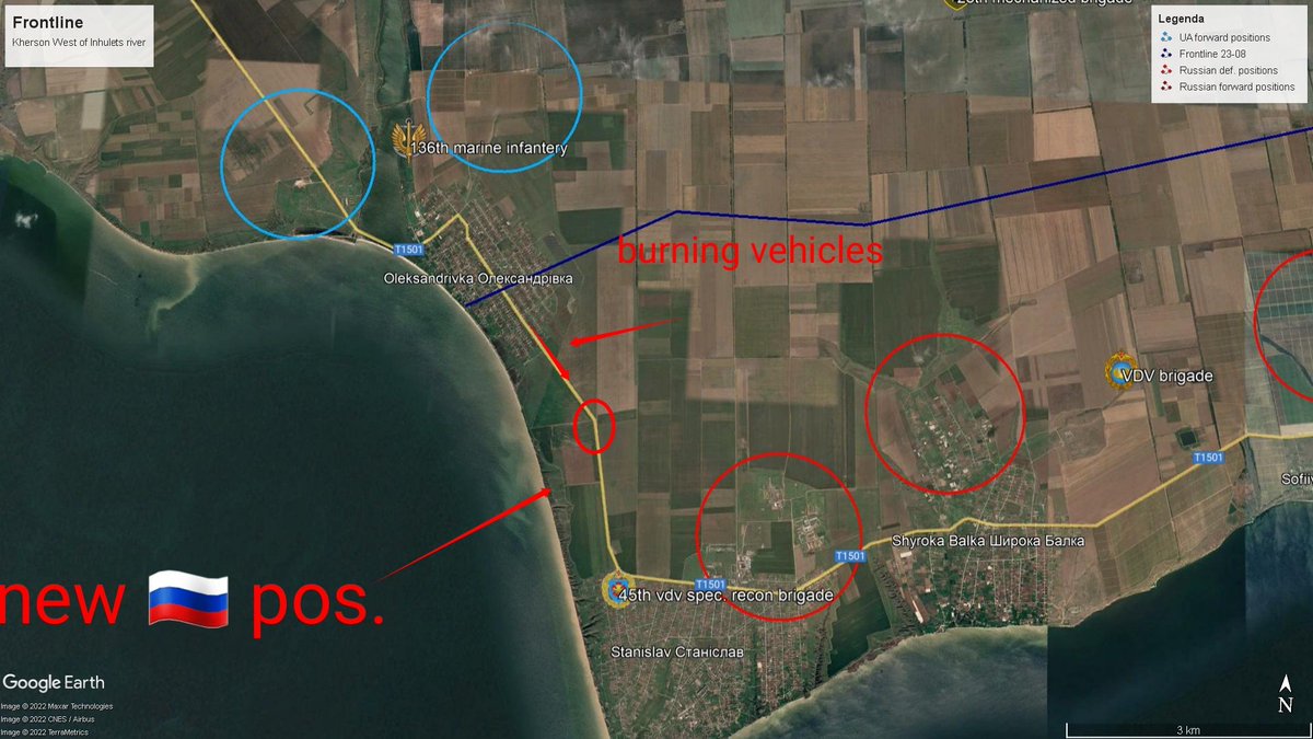
2/11 In the Stanislav area, 🇷🇺 attacked Oleksandrivka some 2 week ago pushing 🇺🇦 back to positions N, last week 🇺🇦 forces countered. 🇷🇺 were pushed back to the S end of town.Burning vehicles have been seen on/near the T-1501 HWY. Town is now contested.
3/11 to the E, 28th mech. Brigade keeps supressing 🇷🇺 artillery in ShyrokaBalka area, 🇷🇺 forces tried to move NW from Sofiivka but where repelled on the line W of Doslidne by forward 🇺🇦 forces.Around Tomyna Balka reportedly multiple MLRS & art. were destroyed by 🇺🇦 artillery.
1/10 #Kherson western front update 🧵is finally here.Been working on checking info from local,#OSINT,sat & other sources to produce the most complete picture IMO while still keeping #Opsec.Let's go 🚀
2/10 First by popular req. a full overview map of the current(8 aug) frontlines west of the #Inhulets river. As we can see there have been some (small) shifts in the overall line. As you can see i have included known 🇷🇺 defensive pos. and some published 🇺🇦 pos. Some details ⬇️
3/10 First we look at the sit. around #Stanislav. 🇷🇺VDV reinforcements arrived 15-7,and started a push toward #Oleksandrivka pushing 🇺🇦 back across the coastal road W and N taking control of the town. 45th Spetnaz are active here. 🇺🇦 are using art. & tank fire to stop the advance
As promissed in my previous 🧵 ⬇️ i will go into the destruction of another ammo depot with #HIMARS in the west-#Kherson region. The one i will take a look at today was located just south of #Novodmytrivka and was hit on 21st of july.
If we look at the #FIRMS data we can see there are a lot of spots on fire around the compound however when looking at the #Sentinel imagery we can see it originates from the N end of the complex and spread on the dry lake bed. This is even more clear using the burned area option.
Burned area option on the #Sentinel imagery makes it possible to see how the fire progressed.We can see spots around the complex which indicates burning material was spread over a large area.This is consistent with a large explosion. (ref. Expl. #Novakhakova 21-7 ⬇️)
Video of 🇷🇺 BM-21 Grad MLRS being loaded & transported to launch site. This recent video published by 🇷🇺 media was supposedly recorded around the town of #Vugledar,#Donetsk oblast multiple launchers can be seen and loading occurs on the road.
At 11 sec. you can see the loaded MLRS driving on a road which bends to the right, in the distance two elec. towers can be seen as well as a field full of powerlines to the left. @neonhandrail geolocated this site. It was geolocated to #Novohryhorivka.
#Vulgledar would have put 🇷🇺 forces atleast 10 km behind the known frontlines in this area.The geolocation however puts it at 23 km away behind 🇷🇺 lines.When we look @ sighting loc. on 22-7 with #Sentinel imagery.we can see the field to the S is burned.
As promissed a 🧵 on what was happening inside #Kherson city yesterday (22-7). I have been in contact some local sources who painted a picture of every growing chaos & fear among 🇷🇺 troops & collaborators inside the city. First it's important to know that during the occupation
The 🇷🇺 invaders have been setting a system of checkpoints on almost any intersection in the city, these are called blockposts by the civilians. Before last week these checkpoints where mostly manned by #Rosgvardiya troops which are a internal mil. force directly under #Putin.
During the last few days,most of these #Rosvguardia seem to have left the city and manning of the checkpoint seemed more lacks. This seems to have increased the number of desertions,farmers in the surrounding areas are being confronted with 🇷🇺 soldiers dressed in civilian clothes