1/ANATOMY OF A SWARM: How #China sent its ships to swarm & intimidate the #Phlippines’ largest outpost in the West Philippine Sea, then scattered after its tactics were made public, 3-11 March 2023.
By 5 March the swarm of Pag-Asa Island was well underway. (1/9) #SouthChinaSea
2/However, by 10 March—perhaps due to the #Philippines’ new transparency initiative—#China had apparently recalculated & decided that swarming was no longer in its interest. Only 10 ships remained in the Pag-Asa Cays. Where did the rest go?
(Hint: not very far) (2/9)
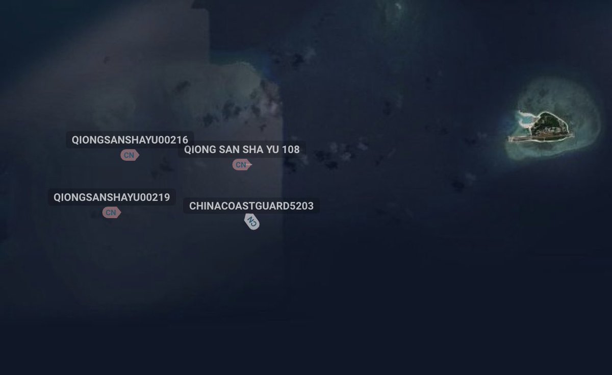
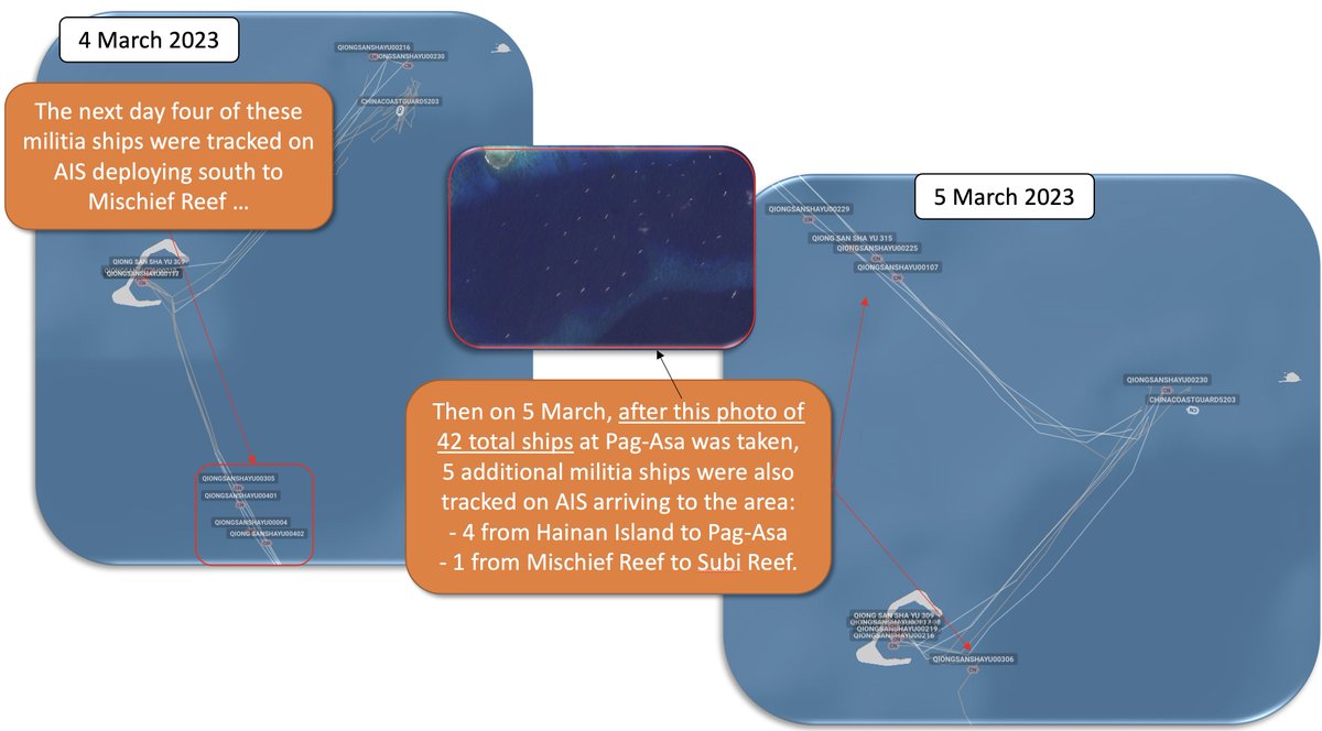
3/Maritime open-source intelligence (#OSINT) relies on a suite of tools. The automated information system (AIS) broadcast by most ships is the simplest, but it has limitations. We used AIS to track the arrival of 7 new PRC militia ships to the Pag-Asa Cays on 3 March. (3/9)
4/#China had 42 ships in the Pag-Asa Cays by 5 March. #Philippines-held Pag-Asa (a “rock” under @UN law) earns a 12nm territorial sea. Nearby PRC base at Subi Reef earns zero because it’s a “low tide elevation”--meaning in its original state it was below water at high tide. (4/9)
5/By 6 Mar we wondered if there was a rotation underway, as 4 militia ships were seen on AIS returning to port at Hainan Island,while one more ship deployed from Hainan to the Pag-Asa Cays. By this time the @coastguardph’s new transparency policy was beginning to take hold. (5/9)
6/Starting 8 March it seemed #China had made a recalculation based on the #Philippines’ recent transparency initiative. At least 3 of the (AIS-visible) militia ships started a meandering dispersal away from Pag-Asa, and we wondered if there were more.
Hint: yes—there were. (6/9)
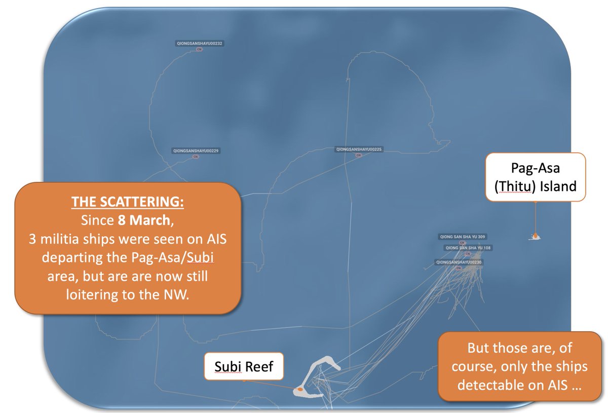
7/Fortunately 10 March offered a clear day when we could go looking for ships not visible on AIS that might be lingering around. We found them. It seemed #China wasn’t enjoying the exposure of the @coastguardph’s new transparency policy & had scattered its swarming fleet. (7/9)
8/#China’s intimidation force dispersed mostly to the north & west in an apparent attempt to evade the #Philippines’ surveillance. Unfortunately for them the weather didn’t cooperate & can see how they’re hiding in plain sight—away from Pag-Asa but close enough to return. (8/9)
9/We can now see maritime gray-zone bullying tactics in near-real time. The #Philippines’ new transparency policy is a game-changer, but efforts like Project Myoushu at @StanfordGKC are also ready to support the free-and-open community to expose #China’s maritime bullying. (9/9)
• • •
Missing some Tweet in this thread? You can try to
force a refresh
1/[Quote] While fewer Chinese vessel seen in Philippine waters may seem to indicate an effort by the Chinese to deescalate tension, “looks can be deceiving,” according to an international maritime expert. (1/4)
2/“Where did they all go? The answer is most are probably still in the area … they’ve just made themselves less visible,” said retired US Air Force Col. Raymond Powell in a series of tweets on Friday. (2/4)
3/He said that was particularly the case of the more than 40 CMM vessels which were recently near Pag-asa that China had scattered around the area to make them less noticeable from the air. (3/4)
1/#China Coast Guard 5203 less than 3nm from Pag-Asa (Thitu) this morning with 3 militia ships (those visible on AIS). This is even closer than noted by @coastguardph yesterday, but not unusual. #China rejects the #Philippines’ right to a 12nm territorial sea around Pag-Asa (1/5)
2/The 2016 @UN Arbitral Tribunal case ruled that Pag-Asa carries the legal status of a “rock” under int’l law, meaning it’s always above water but can’t organically support human habitation. This affirmed its right to a legal 12nm territorial sea. (2/5) amti.csis.org/thitu-island/
3/The Tribunal took no position on who “owns” which features in the Spratlys. For Pag-Asa it noted the #Philippines has occupied it since 1970 & claims only the 12nm sea earned by “rock” status (no separate exclusive economic zone). Pag-Asa lies outside any country’s EEZ. (3/5)
1/The preponderance of the evidence suggests that on 6 Feb #China Coast Guard ship 5205 stopped, harassed and followed #Philippines Coast Guard BRP Malapascua near Sabina Shoal for 8+ hours, preventing it from returning to Palawan. Let me explain my reasoning. [Thread 1/7]
2/BRP Malapascua (@coastguardph MRRV-4403) left Pag-Asa (Thitu) Island moving SE on 5 Feb/0930 PHT after anchoring overnight. Its companion for that night, BRP Teresa Magbanua (MRRV-9701), would move off to the NE 14 hours later. [2/7]
3/BRP Malapascua seemed headed to Palawan, but 3 hours after it left Pag-Asa CCG 5205 (marked "Unknown") left Mischief Reef moving west, came to a stop right across Malapascua's path & then at 1940L went "dark" (stopped transmitting its Automatic Identification System/AIS) [3/7]
1/What exactly happened between #China and the #Philippines last week in the W. Philippine Sea? Why are these two PH Coast Guard ships now sitting off the coast of Pag-Asa (Thitu) Island? And how does it all relate to the strange journey of the BRP Andres Bonifacio? [Thread 1/14]
2/First some background: PH Coast Guard ship BRP Teresa Magbanua (MRRV-9701) was acquired from #Japan in 2021. It was recently deployed in support of Philippine fishermen near Ayungin (Second Thomas) Shoal after reports of PRC harassment there. [2/14] manilatimes.net/2023/01/22/new…
3/At about that time (22 Jan/1330L) the BRP Magbanua's automated information system (AIS) stopped transmitting while still east of Palawan, indicating the @coastguardph ship likely did not want its movements tracked during its West Philippine Sea operations. [3/14]