Last Wednesday (08-07-19), I flew on the @NASA DC8 for the first time, when the plane sampled the #WilliamsFlatsFire for #FIREXAQ. We sampled the fire for 3 hours (5pm-8pm PT) making 10+ passes into smoke & pyrocumulus.

This thread is a sample of photos I took on the flight. Image
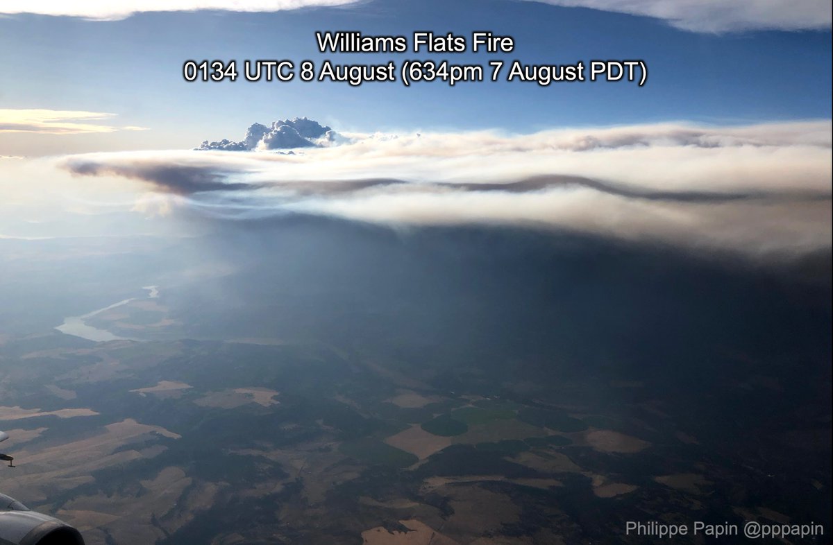
@NASA We first did an east-to-west longways pass over the smoke & Pyrocumulus (#PyroCu) cloud around 5pm PT. This photo suggests that the PyroCu updrafts are lofting smoke well above the boundary layer.

You can also see the Columbia River in the right part of the photo. Image
@NASA Immediately afterwards we saw the source of the #WilliamsFlatsFire below attempting to cross the mountains. Image
@NASA After that, we did a bunch of north-south transects through the smoke plume downstream of the fire. We flew as low as 12,000ft on these transects in an attempt to sample the thickest part of the smoke. At the thickest parts, the sun is barely visible as a red disk in the smoke. Image
@NASA In case you were wondering, yes you can smell smoke inside the DC8. It smells differently in the center vs. the edge of the smoke plume, likely related to different chemistry.

The good news is smelling the smoke is relatively safe (you inhale more aerosols in a campfire on avg).
@NASA This might be my favorite photo of the #WilliamsFlatsFire. Looking from the south, you can see the PyroCu poking above the smoke layer.

Note also the multiple smoke layers, separated by a clear gap. Not sure what causes these stratification layers, but they sure look cool! Image
@NASA While we flew over & through the smoke plume, there was an onboard LIDAR taking observations all along the way. This was from an east-west overpass over the #WilliamsFlatsFire. You can see how clouds attenuate the signal much more than the smoke further downwind. Image
@NASA Okay maybe I lied, I think this photo nearing sunset takes the cake! You can see the entire fire sloped from the ground, up to the PyroCu & smoke plume on the right edge.

Just absolutely stunning. Photos don't do it justice. Image
@NASA Okay, one last photo, showing the DC8 flight track through the #WilliamsFlatsFire on 08-07-19 w/ true color GOES-16 imagery overlaid.

This was still in-flight, as we did one more set of N-S passes after, but it gives you an idea of the sampling strategy through the smoke plume. Image
@NASA If it wasn't already obvious, this has been such an incredible experience to be part of #FIREXAQ.

I usually study TCs & midlat dynamics, so this was a bit out of my comfort zone, but I'm thankful @DrDavePeterson asked me to help as a lead forecaster for the campaign.

fin.

• • •

Missing some Tweet in this thread? You can try to force a refresh
 

Keep Current with Philippe Papin

Philippe Papin Profile picture

Stay in touch and get notified when new unrolls are available from this author!

Read all threads

This Thread may be Removed Anytime!

PDF

Twitter may remove this content at anytime! Save it as PDF for later use!

Try unrolling a thread yourself!

how to unroll video
  1. Follow @ThreadReaderApp to mention us!

  2. From a Twitter thread mention us with a keyword "unroll"
@threadreaderapp unroll

Practice here first or read more on our help page!

More from @pppapin

26 Aug
For this elevation (beam height from KLCH is around 16,000ft which is ~550-hPa), these radial velocities seen in the E eyewall of #Laura are incredible. Yes that is an inbound 160-mph velocity... at 550-hPa!

This is a very powerful and deep vertical circulation.
And if you go pixel hunting for the maximum velocity pixel, there are values that are larger than that too. The latest scan for example has a 169-mph pixel!

The @53rdWRS normally samples strong hurricanes at 700-hPa as winds decrease w/ height. This is well above that level!
I’m just gonna continue sharing incredible #Laura velocities in this thread. Now up to 173mph in the NE quad.
Read 5 tweets
30 Oct 19
It's been a hard week for CA w/ major wildfires (#GettyFire, #KincaidFire) affecting the state.

Synoptic weather context is key: Fires were aided by repeated mountain & gap winds via ridge building over the Great Basin. This ridge building enhances the pressure gradient over CA.
The synoptic weather sets the stage, but the mountain interaction enhances the winds further.

Let's illustrate the mesoscale details w/ a cross-section across the coastal CA mountain ranges. Hurricane force (#SantaAna) winds form as cold easterly flow tries to cross the barrier.
The record-breaking cold pool intensity associated w/ a 1045-hPa ridge is one reason why this last mountain wind event for southern California may be the worst.

Inland, 850-hPa temps are at record lows, but adiabatic compression modifies the air to near climo on the coast.
Read 5 tweets
2 Sep 19
Here is the sequel to my steering flow animated explanations. I'm covering 2 periods.

1st period is when #Dorian is expected to stall.

3 Features Cancel out:
1) Ridge over the NATL
2) Ridge over the Midwest
3) Trough that creates a weakness between the two ridges.
So naturally the next question is, what causes the #Dorian to start moving again?

Essentially one ridge becomes stronger (NATL ridge), while the other one weakens (Midwest US), with progressive troughs making sure the weakness stays open. Breakdown below⬇️
So in retrospect, it's not the trough picking up the storm, but rather the transient troughs provide a weakness that then gives #Dorian a path to then be directed around the clockwise circulation of the NATL ridge.
Read 4 tweets
30 Aug 19
Okay so while all attention is on #Dorian, let's do a quick tour of the rest of the NATL tropics currently, because there are some other systems to talk about.

There is a weak llvl circ. n/ Cuba W of Dorian. It should move into the GoM where it has a chance to organize further.
Next up is an African Easterly Wave that just emerged off the coast. The model guidance has been somewhat optimistic on this wave developing over the next 5-7 days, so worth keeping an eye on it. Aside from the Cape Verde islands, no threat to land.
Let's continue. There is yet another wave out in the middle of the NATL basin. Its battling some fairly strong westerly shear currently, but some models suggest it will get into a more favorable environment as it moves off to the northwest. #Bermuda should keep an eye on it.
Read 5 tweets
28 Aug 19
1/9: Over the last 24 hours there have been large eastward shifts in #Dorian's track. It may now just clip #PuertoRico to the east! How?

Let's start with Dorian's vertical structure. One critical change is how vertically coherent Dorian's vortex has become, as seen below.
2/9: Here is another way to view it, this time from a lat-lon map. Over the last four GFS model cycles, the separation between the low & mid level centers of #Dorian decreases until they are on top of each other.

Correspondingly the low-level vortex migrates to the northeast.
3/9: Since #Dorian's vortex is more vertically stacked, it feels a deeper steering layer, moving it more north vs. the low-level flow.

Yesterday's 06z GFS run had a shallow vortex, & its steering was impacted by the low-level Caribbean trade winds (925-700-hPa) into #Hispaniola.
Read 10 tweets
11 Jul 19
1) Now that #Barry has formed in the Gulf of Mexico, let's talk about how the forecast has evolved from a few days ago.

First, it appears the GFS handled Barry's initial structure better, with a low-level circulation removed from the mid-level vortex.
2) This is a result of continued northerly shear & dry air advection, which is both from the upper-level ridge poleward of Barry & also a dangling PV Streamer which folded under the ridge off the eastern coast.
3) While previous forecasts had Barry track west towards the LA/TX border, its decoupled structure argues against that now.

The system is now more likely to be steered by low-level flow into a weakness. The ridge SE of Barry is stronger in the low-levels than the one to the NW.
Read 6 tweets

Did Thread Reader help you today?

Support us! We are indie developers!


This site is made by just two indie developers on a laptop doing marketing, support and development! Read more about the story.

Become a Premium Member ($3/month or $30/year) and get exclusive features!

Become Premium

Too expensive? Make a small donation by buying us coffee ($5) or help with server cost ($10)

Donate via Paypal Become our Patreon

Thank you for your support!

Follow Us on Twitter!