#NovaScotia’s northernmost documented mineral occurrence is on St. Paul Island, an extension of the Appalachian Mountains, north of #CapeBreton!
Check out the history of this neat island: the Graveyard of the Gulf!
#nspoli #cbpoli @TourismCB @TourismNS @NS_Museum @JaimeBattiste
Check out the history of this neat island: the Graveyard of the Gulf!
#nspoli #cbpoli @TourismCB @TourismNS @NS_Museum @JaimeBattiste
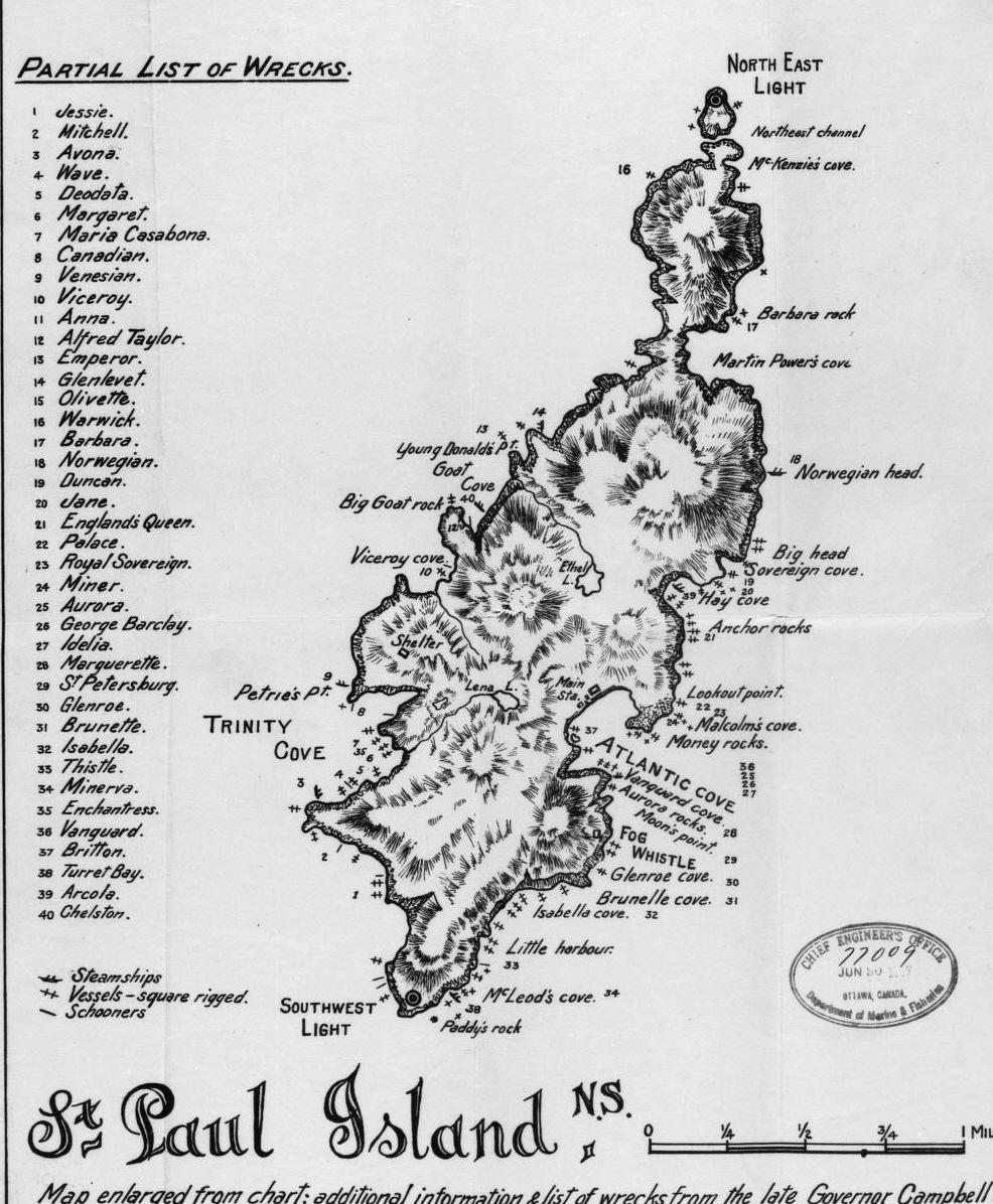
The mineral occurrence isn’t of any significance – it’s a small outcrop of galena, sphalerite and pyrrhotite in limestone, and marcasite in small quartz veins – but it’s as far north as you can go in #NovaScotia.
#nspoli #cbpoli #capebreton
#nspoli #cbpoli #capebreton
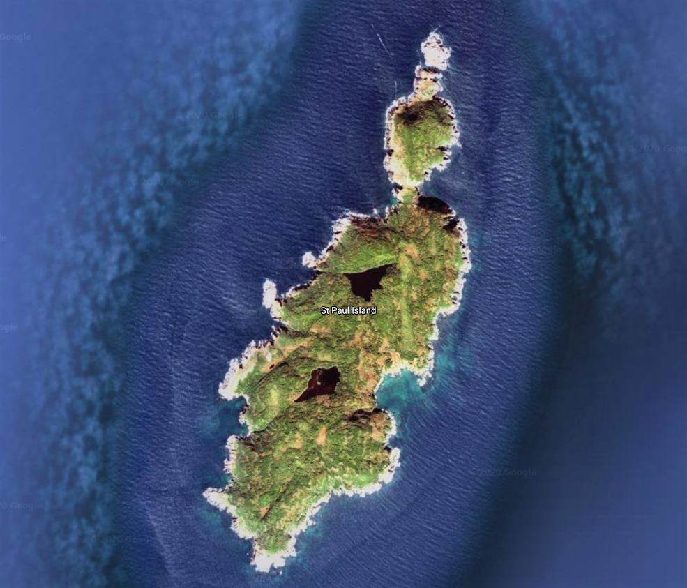
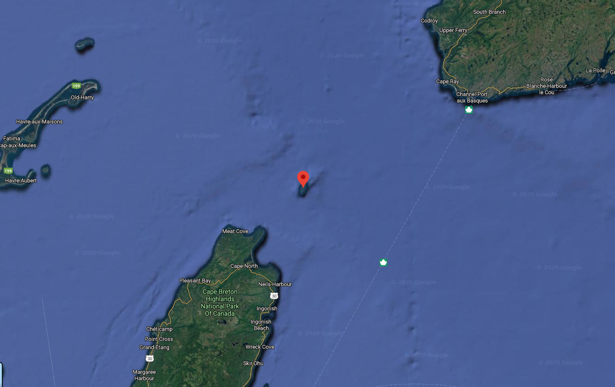
What is interesting is St. Paul Island itself. It's in The Cabot Strait, at the entrance of The Gulf of St. Lawrence, about 14 miles from Cape Breton.
#NovaScotia #nspoli #cbpoli #capebreton
#NovaScotia #nspoli #cbpoli #capebreton

It is an extension of the Appalachian Mountains, which started forming 480 million years ago as North America and North Africa collided. The Appalachians ran 2400 kilometres from Newfoundland to Alabama, right through the Maritimes.
#NovaScotia #nspoli #cbpoli #capebreton
#NovaScotia #nspoli #cbpoli #capebreton

The Appalachians were taller than the Himalayas but are mostly eroded now. The #CBHighlands and St. Paul Island are both remnants of them.
#NovaScotia #nspoli #cbpoli #capebreton
#NovaScotia #nspoli #cbpoli #capebreton

The Aspy Fault, a prominent feature of northern Cape Breton’s geology, extends north from the #CBHighlands and passes just to the east of St Paul's underwater.
#NovaScotia #nspoli #cbpoli #capebreton
#NovaScotia #nspoli #cbpoli #capebreton

In fact, it carries on to Newfoundland and during supercontinent Pangea, when #NovaScotia was connected to western Europe, the Aspy Fault was likely connected to Scotland's Great Glen Fault, home to Loch Ness.
St. Paul is known as the Graveyard of the Gulf.
#nspoli #cbpoli
St. Paul is known as the Graveyard of the Gulf.
#nspoli #cbpoli

It's often fog-bound cuz of the different temperatures of the Gulf Stream and Labrador Current which meet in the area. The island therefore posed a significant hazard during the Age of Sail with its location in the middle of shipping routes. It had 350 ships wreck on its shores.

For example, a three-masted barque called the Jessie left Charlottetown on December 24, 1824 and was caught in a snowstorm which drove her onto St. Paul Island. The survivors’ fires could be seen from the mainland but because of pack ice, no rescue vessel could reach them.

They survived nearly 11 weeks but eventually succumbed to starvation. Being marooned on the island meant almost certain death back then due to the lack of animal life on St. Paul and the harsh weather in the Cabot Strait.
#NovaScotia #nspoli #cbpoli #capebreton
#NovaScotia #nspoli #cbpoli #capebreton

Back in Charlottetown the fate of the Jessie was unknown until a French sealer who had visited St. Paul Island in the spring was apprehended by Mrs. Mackay, the wife of the Jessie’s owner, who saw the man wearing her husband's coat.
#NovaScotia #nspoli #cbpoli #capebreton
#NovaScotia #nspoli #cbpoli #capebreton

She pulled the coat open and found her husband’s initials, which she had sewn into the lining. Police were notified and the man explained how he and others had visited the island in the spring, as fishermen often did, to hunt seals and salvage shipwrecks.
#NovaScotia #nspoli
#NovaScotia #nspoli

A ship was sent to the island and Donald Mackay's body was recovered along with his diary. The final entry was on March 17 and it indicated that he was the last survivor. Jessie’s Cove takes its name from the wreck.
#NovaScotia #nspoli #cbpoli #capebreton
#NovaScotia #nspoli #cbpoli #capebreton

The ongoing loss of life compelled the government of Nova Scotia in 1831 to place a frame house and provisions at a cove on the southeast side of the island to help shipwreck victims. After the house had been built, workers cut a road across the island and...
#NovaScotia #nspoli
#NovaScotia #nspoli
...discovered a small lifesaving station on the western shore that the government of New Brunswick had built and staffed with two men and their families. The two provinces had had no idea what the other was doing.
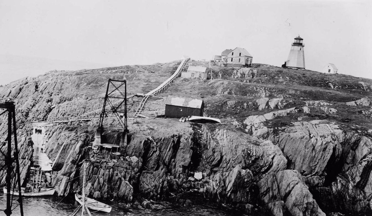
In 1839, two lighthouses were built.
#NovaScotia #nspoli #cbpoli
In 1839, two lighthouses were built.
#NovaScotia #nspoli #cbpoli

In the north one was built on a small island that is separated from the northeast end of St. Paul Island by a narrow passageway known as The Tickle or The Tittle. Another was built on the southwest point of the island.
#NovaScotia #nspoli #cbpoli #capebreton
#NovaScotia #nspoli #cbpoli #capebreton

A lifesaving station was also built at Atlantic Cove, about mid-island on the eastern shore. Both lighthouses were octagonal wooden towers 40 feet tall.
The wooden lighthouse in the northeast was replaced with a concrete tower in 1962.
#NovaScotia #nspoli #cbpoli #capebreton
The wooden lighthouse in the northeast was replaced with a concrete tower in 1962.
#NovaScotia #nspoli #cbpoli #capebreton

The lighthouse in the southwest burned down in 1914 and was replaced by a cast iron, cylindrical lighthouse in 1915. This was in turn replaced by an automated system in 1964.
The cast iron lighthouse (the 1915 version) is surprisingly well-travelled.
#NovaScotia #nspoli #cbpoli
The cast iron lighthouse (the 1915 version) is surprisingly well-travelled.
#NovaScotia #nspoli #cbpoli
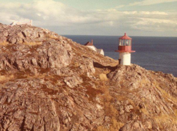
Designed to be easily-moved, it was fabricated at the Dominion Lighthouse Depot in Prescott, Ontario, and shipped by train and boat to St. Paul Island.
#NovaScotia #nspoli #cbpoli #capebreton
#NovaScotia #nspoli #cbpoli #capebreton
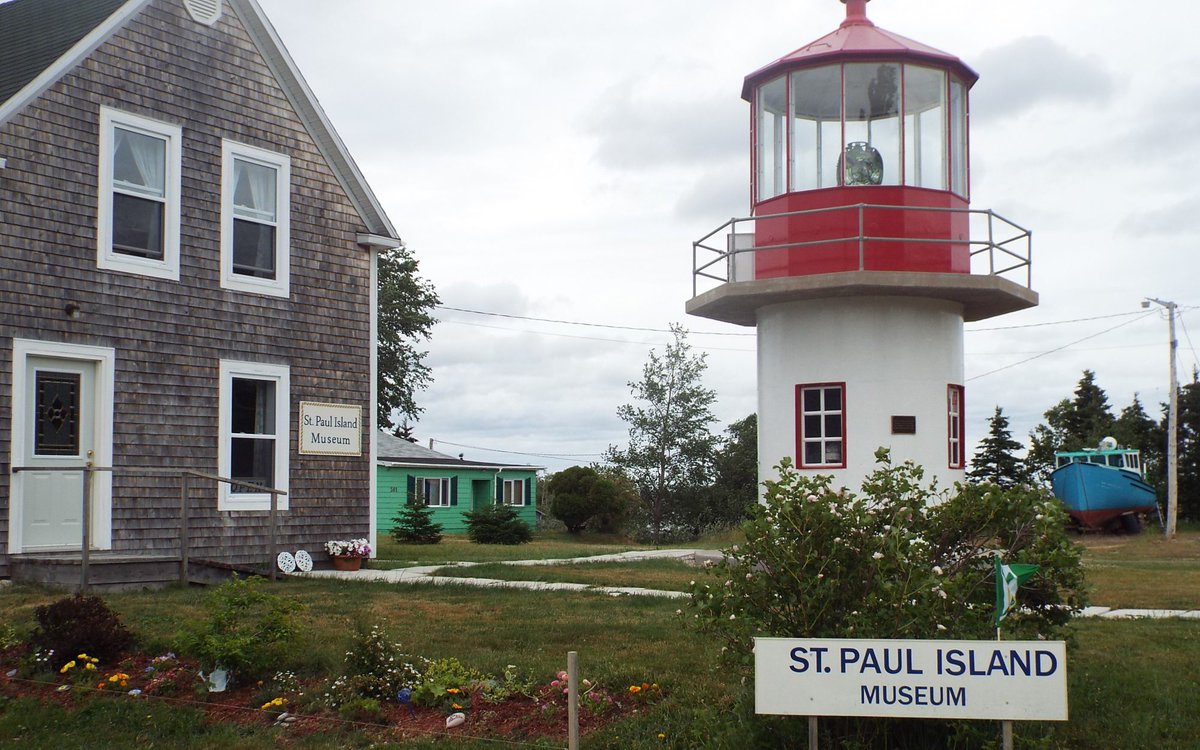
It was in the southwest corner of St. Paul Island from 1915-1982 and then at the Canadian Coast Guard base in Dartmouth from 1982-2011. In 2011, it was moved to #Dingwall, Cape Breton, where it is currently at the St. Paul Island Museum.
#NovaScotia #nspoli #cbpoli #capebreton
#NovaScotia #nspoli #cbpoli #capebreton

St. Paul Island also hosted a radar station in WWII and a Marconi wireless station.
The island has been uninhabited for decades.
#NovaScotia #nspoli #cbpoli #capebreton
The island has been uninhabited for decades.
#NovaScotia #nspoli #cbpoli #capebreton

• • •
Missing some Tweet in this thread? You can try to
force a refresh