Tropical Storm Warning posted for South Florida and the Keys.

Forecast track for Eta as a robust tropical or subtropical storm nudged northward to the Upper Keys and south Miami-Dade with the latest NHC advisory. The Euro and Japanese models only holdouts showing FL Straits
The intensity forecast from NHC has remained unchanged over the last several advisories. It is more aggressive than the model forecasts, which, eyeballing it, average to a ~50 MPH max wind storm. However, given the track adjustment, chances for storm-force winds increased.

2/
Chance for tropical storm winds (%)

Orlando 15
Ft Pierce 28
W Palm Beach 43

Ft Lauderdale 51
Miami 41
Homestead 41

Marathon 42
Key West 34

Naples 46
Ft Myers 33

Based on NHC 10 AM EST #Eta

(note: FLL airport is a coastal ocean exposure and therefore has a higher %)

3/3
Important detail: #Broward County and points north have been left *out* of the Tropical Storm Warning. Those areas remain under a TS Watch.

4/3 fin #eta

• • •

Missing some Tweet in this thread? You can try to force a refresh
 

Keep Current with John Morales

John Morales Profile picture

Stay in touch and get notified when new unrolls are available from this author!

Read all threads

This Thread may be Removed Anytime!

PDF

Twitter may remove this content at anytime! Save it as PDF for later use!

Try unrolling a thread yourself!

how to unroll video
  1. Follow @ThreadReaderApp to mention us!

  2. From a Twitter thread mention us with a keyword "unroll"
@threadreaderapp unroll

Practice here first or read more on our help page!

More from @JohnMoralesNBC6

8 Nov
Sunday coffee Eta briefing:

The dry air from the upper level low has arrived, while wind shear and land interaction impact the storm. The storm is, at least for now, weakening. Tellingly, the Hurricane Watch for South Florida has *not* been upgraded to a Warning.

1/
Models, which have now benefited from 2 surveillance missions from the G-IV jet sampling the environment on 3 sides of Eta, have joined the anticipatory Euro which was calling for a hard-left out of Cuba. While that turn has yet to happen, Eta is slowing — a sign of imminent turn Image
As a result, NHC has pushed their forecast track south yet again — now showing the center passing 94 miles away from Miami and making landfall as a robust tropical (or subtropical) storm in the Lower Keys very late tonight. On the map, blue depicts the Tropical Storm Warning

3/ Image
Read 8 tweets
7 Nov
I’ve been answering everyone individually but let’s do a shutters post for all. Shutters are generally required for winds in excess of 105 mph, which are the ones that can lift non-aerodynamic objects like roof tiles and such. Eta is forecast to be a 70 MPH tropical storm

1/
Now, that’s not to say that there isn’t an outside chance that it will become a Cat 1 hurricane and — this is important — *sustain* that intensity through Monday. So, let’s consider a reasonable worst case scenario. Conveniently, @NWSMiami does that for us.

2/ Image
@NWSMiami This is considered a scenario that has a 10% chance of occurring. It shows hurricane winds for coastal #Miami-Dade east of I-95 or US-1 and the Upper Keys. There’s a 90% chance that it won’t happen, and anything stronger isn’t in the cards according to the experts.

3/
Read 5 tweets
21 Aug
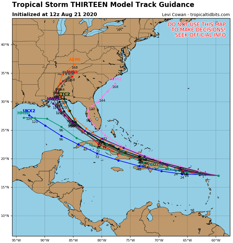
Major changes in the last 12 hours: A new center of circulation has formed in the depression, and 45 mile per hour (75 km / hr) winds were detected in what is now classified as Tropical Storm #Laura.

** en español en facebook.com/johnmoralesnbc…

1/
This new vortex location, no less than 70 miles south of where the National Hurricane Center (NHC) had estimated it was located, puts the Leeward Islands, Virgin Islands, Puerto Rico and the Dominican Republic in play.

2/
Tropical Storm Warnings will likely be issued at 11 AM for everyone, with the possible exception of the Dominican Republic where they may start with a Storm Watch first. In other words, it is now much more likely that storm winds will be felt…

3/
Read 9 tweets
24 Jun
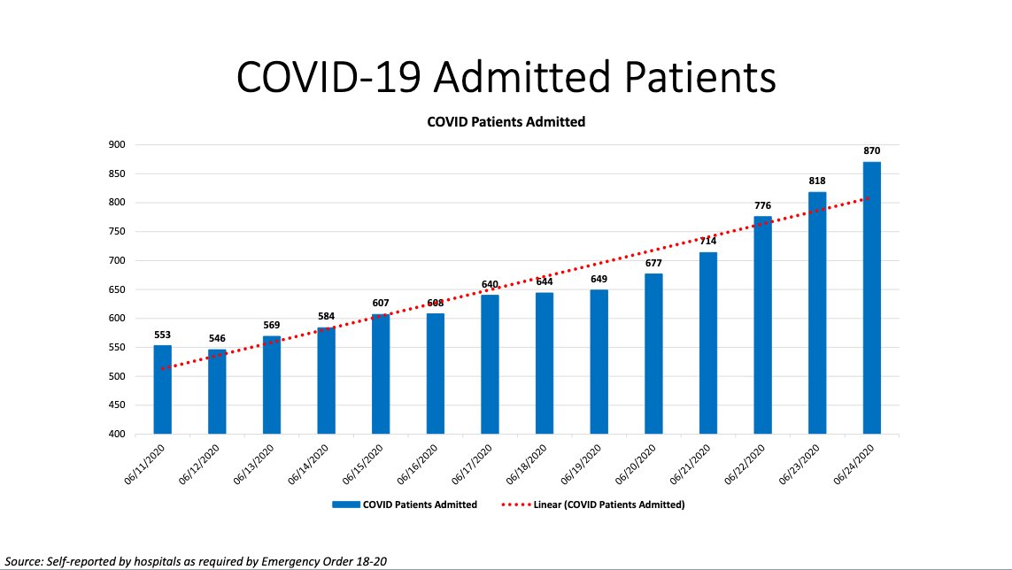
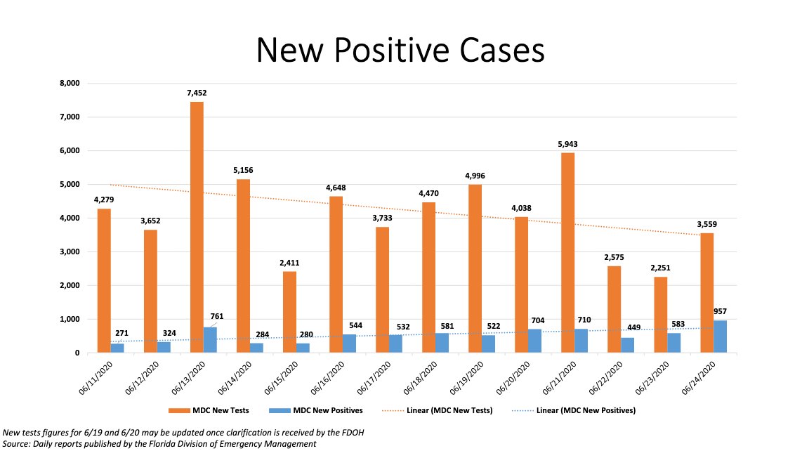
Florida and the U.S. both set new records for #COVID cases today. Higher than March, higher than April. The highest it’s been. Yet I have a *select* few followers from South Florida who call me a fear-mongerer for sharing these facts. Let’s review their arguments:

1/
Hospitalizations are down, they insist

(source: @MiamiDadeCounty)

2/
@MiamiDadeCounty Testing more, they say…

(Testing in orange. Source: @MiamiDadeCounty)

3/
Read 14 tweets
15 Apr
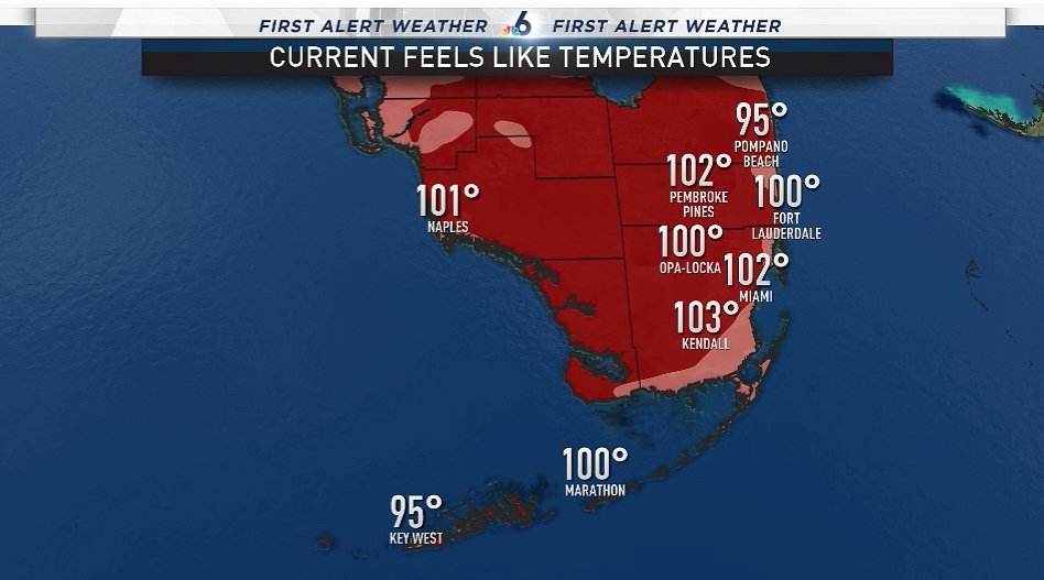
Dumbfounded. Stunned. Astonished. @AngieNBC6 @SteveMacNBC6 and I are on conference readying today’s @nbc6 weathercasts and we’re overwhelmed by the sheer number of crazy heat records falling like flies here. This is July weather in April. First, here are current heat indexes.
90°+ days in 2020 up to this date = new record of 8 (previously 6)

75°+ nights in 2020 up to the date = new record of 17 (previously 16)

Earliest hottest weather of the year record has been set 3 times

Earliest 4 straight nights at 78°+ = new record by over 2 weeks (2017)

2/
19 heat records in 8 days collectively for #Miami, Fort Lauderdale and #KeyWest

Ratio of record heat to record cold in #Miami so far this year is 21-0

I stopped counting but up to February Fort Lauderdale had 120 record hot temperatures without a single cold record since 2015.
Read 5 tweets
14 Oct 19
I don’t know if it’s being forced to watch the frequency at which deeper and more widespread saltwater inundation is impacting some neighborhoods in South Florida, or if it’s the inner demons released when teenagers like #Greta admonish adults, but this fall ...

1/
I’ve had an inordinate number of, um, skeptics (I’m trying to be kind) bending themselves into pretzels trying to contradict what we in #miami and Fort Lauderdale are plainly seeing with our own eyes:

the cities are under siege from the surging seas.

2/
They throw around all their expertly-gathered (#sarcasm) alternative facts, like “what do you expect when you build on a swamp?” Let me enlighten you:

3/
Read 12 tweets

Did Thread Reader help you today?

Support us! We are indie developers!


This site is made by just two indie developers on a laptop doing marketing, support and development! Read more about the story.

Become a Premium Member ($3/month or $30/year) and get exclusive features!

Become Premium

Too expensive? Make a small donation by buying us coffee ($5) or help with server cost ($10)

Donate via Paypal Become our Patreon

Thank you for your support!

Follow Us on Twitter!