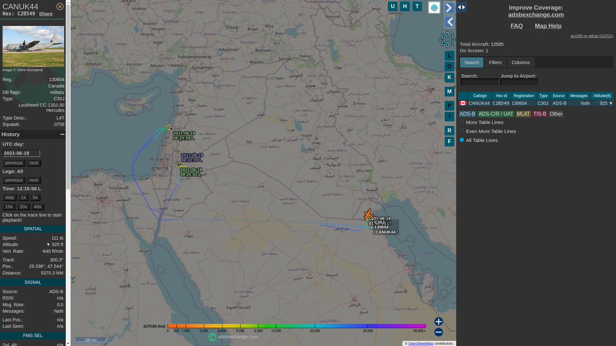
๐จ๐ฆ #RCAF CC-130J Hercules 130604 #C2B549 has been operating in the Middle East supporting various missions for months, like #OpIMPACT, and today I noticed they seemed to change their interpretation of their SOP while overflying #Iraq ๐ฎ๐ถ.
๐จ๐ฆ #RCAF CC-130J Hercules 130604 did not change their transponder from ADS-B to Mode-S when transiting Iraqi airspace, which is the norm for all RCAF flights over #Iraq, including their own previous flights, presumably for OPSEC reasons. #C2B549
๐จ๐ฆ #RCAF CC-130J Hercules 130604 conducts operations across the Middle East, so we get a good sample of flight data to analyze.
When doing the regional milk-run, they use ADS-B, and that's fine, nobody is going to take shots at them over relatively peaceful countries. #C2B549
From what I understand, using Mode-S is the norm over Iraq because their location (lat/lon) is not included in the data sent over the air, it needs to be triangulated by ground stations with MLAT. ADS-B sends their exact location in the message being transmitted.
I suspect someone forgot to flip a switch in 130604 today, and as a result flew much of their route in a more visible emissions posture than usual. ๐คทโโ๏ธ
๐บ๐ธ United States Air Force C-17A Globemaster III 95-0102 took off from Joint Base Charleston (or somewhere in that area) at ~21:30 Z using Mode-S, which is unusual; they use Mode-S when they don't want to be as noticeable, like over Iraq. #AE07E5#RCH233
Because they were using Mode-S, their location had to be geolocated using multilateration (MLAT) and only a few coordinates were seen from the ADSBexchange network.
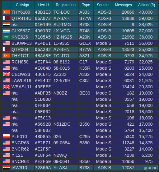
๐ฎ๐ถ Let's look at the "layer cake" over #Iraq
( Someone who actually works in ATC will laugh at me, but I don't want to work for ATC ๐ )
Above 35,000ft we have at least 7 airliners, all broadcasting ADS-B, as commercial air traffic does.
We also have one #USAF E-11A BACN 11-9355 #AE4DE1 c/s #BLKWF13 at 36,000ft broadcasting Mode-S; a military plane, in the middle of the civ air traffic.
- No RC-135s in the air over the Black Sea that I know of.
- There could be a U-2 (because there could always be a U-2, they show up seldomly when they're taking off / landing / in transit)
๐บ๐ธ #USNavy Arleigh Burke-class destroyer USS Ross (MMSI:338822000|CS:NGWB), doing 13kn, is being tailed by another vessel labelled "U153" with an MMSI of 45678458 (invalid) #USSRoss#DDG71#6thFleet โ
It would be swell if @JohnMooneyST
influenced his editors to correct the headline at least. No #RuAF ๐ท๐บ aircraft were in Irish airspace at any time. That's misinformation at best, #disinformation at worst; they were in international airspace the whole time thetimes.co.uk/article/concerโฆ
Journalists are regularly fed bad info by their trusted sources who want to mislead them and spin the story, so I can hardly blame @JohnMooneyST who did his due diligence. The Flight Information Region #FIR is the correct term, the international airspace controlled by Irish ATC.
Sovereign Irish airspace extends 12 Nautical Miles out to sea, the flight information region #FIR extends hundreds of miles out to sea. #NORAD is much more diligent in explaining that difference, as they do in the linked PDF below, from a few years back.
๐จ๐ฆโ๏ธ One of two #RCAF-leased King Airs (C-GSYC) were maybe making a VIP transport between Winnipeg, Sault Ste. Marie, and Trenton. I call these the shadow VIP transport fleet, b/c they seem to ferry the brass around (incl #NORAD). #CFC1648#C076A3
Oh yes, I remember @mikercarpenter, he was spreading #disinformation about the Russian Open Skies Treaty-certified plane spying on Chicago back in 2019, when they were in transit on their way to Cali, not taking pics at all.
It's like a trip down memory lane! I wonder what #disinformation@mikercarpenter has been spreading about the Open Skies Treaty since? Well he locked his account so you can't find out. Too bad for you.