In the Gulf of Mexico, #99L's track will be set in part by its intensity.

An area-averaged sounding around the storm reveals subtle differences in low vs mid/upper-level steering.

A stronger storm wld feel SSE winds ~300mb and move more to the N resulting in landfall farther E.
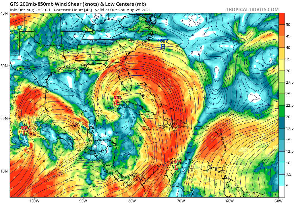
With ocean temperatures approaching 30C, no dry air in sight and near total command of the upper-level wind field, it's honestly hard to see a scenario where #99L doesn't rapidly intensify in the Gulf.

So watch out for potential further shifts east in the forecast track.
It's always wise to have an eye on possible failure modes, so I think if #99L manages not to rapidly intensify in the Gulf, it would be due to interaction with NW Cuba disrupting its core AND #TD14 in the EPAC intensifying faster than expected so its outflow could shear 99L.
While this scenario remains possible, it's the kind of thing we'll hope for but not plan on.

Folks from E #TXwx over to #ALwx should dust off their hurricane plans today and begin thinking about what preparations might be needed if/when watches are issued tonight or tomorrow.

• • •

Missing some Tweet in this thread? You can try to force a refresh
 

Keep Current with Jack Sillin

Jack Sillin Profile picture

Stay in touch and get notified when new unrolls are available from this author!

Read all threads

This Thread may be Removed Anytime!

PDF

Twitter may remove this content at anytime! Save it as PDF for later use!

Try unrolling a thread yourself!

how to unroll video
  1. Follow @ThreadReaderApp to mention us!

  2. From a Twitter thread mention us with a keyword "unroll"
@threadreaderapp unroll

Practice here first or read more on our help page!

More from @JackSillin

6 Sep
As we start a new week, let's check in to see what's on the menu down in the tropics.

-#Larry recurves into the North Atlantic, perhaps brushing NL.

-#91L may still develop but probably not until it moves east of FL.

-New Caribbean wave to watch.

-Maybe a new EATL storm. Image
Right now, of the three storms that have yet to develop, the new Caribbean system probably deserves the most scrutiny.

It will form in a manner similar to Ida and 91L, which means it could either become an impactful storm or wander west into Central America. Image
#91L isn't looking too hot this morning given the wind shear and dry air we've been talking about for several days.

We'll watch to see if any circulation might be able to form under the deeper convection that has been popping up this morning due west of Key West.
Read 5 tweets
5 Sep
As someone:
-without a meteorology degree
-very self-conscious about how those in the field regard me as a person/info source
-who makes mistakes

I’m very familiar with feeling nervous about being labeled a source of misinfo.
I’m never going to be perfect but I try very hard to respond to and improve from criticism.

Neither outlet I mentioned in my earlier tweet has ever made even cursory gestures in that direction, hence the rather harsh approach in dealing with them.
I definitely don’t want my initial tweet to be interpreted as “HS kids in their parents basement are the problem” as someone who has done (and is still doing! And will still be doing until May!) a lot of tweeting without the requisite degrees.
Read 5 tweets
5 Sep
As we're in peak Hurricane Season and the tropical Atlantic remains active, here's a quick reminder to make sure you're tuned into reliable sources (first and foremost @NHC_Atlantic) and tuned out of the cacophony of misinformation.

Here's some BS I've been asked about today: ImageImage
@NHC_Atlantic Both of these outlets are well-known purveyors of misinformation about tropical cyclones. If you're following them, I suggest the unfollow button.

If friends/family ask you about their posts, I'd make the same suggestion.
@NHC_Atlantic Remember:
-ONLY the NHC makes determinations about what category a storm is, and anyone claiming to do so is leading you astray.

-NO long range (7-10day+) deterministic model forecast is worth posting or getting concerned about.
Read 5 tweets
29 Aug
11PM update on #Ida is in from NHC.

Winds still steady at 105mph as the pressure falls to 964mb.

Satellite presentation continues to improve, but we'll have to wait until the next recon plane arrives in a few hours to see whether that's translating to stronger winds.
Winds haven't come up as much as anticipated today, due largely to some lingering chaos in the inner core after Cuba.

But the storm has picked up tons of energy, dropping its central pressure by >20mb and pushing hurricane force winds dozens of miles from the center.
All environmental and satellite indicators continue to point towards rapid intensification tonight.

That's what folks should expect and plan on.

Regardless of what max winds a few spots see in the eyewall, surge and rain will be catastrophic.
Read 4 tweets
28 Aug
During Laura last year, I cobbled together a little visual to monitor trends in the storm's track and distinguish steady trends from short-term wobbles.

Well the #wobbleplot is back for #Ida. Satellite fixes suggest the storm remains towards the eastern edge of track guidance. Image
Checking in on the #WobblePlot roughly an hour later, #Ida is still following the NE side of the ensemble guidance envelope.

I've penciled in the mental adjustment to ensemble guidance I've been making in light of these trends.

The core may get rather close to New Orleans. Image
12:05 PM 8-28-21 #WobblePlot update shows plenty of wobbling, last hour it was to the west this hour to the north.

But the general trend remains pretty steady. #Ida is still tracking along the eastern edge of forecast model guidance. Image
Read 6 tweets
28 Aug
Very latest Vortex Data Message from @53rdWRS shows #Ida's eyewall now open to the NW, a 180-degree change from the NOAA pass an hour or so ago.

This indicates instability in the eyewall from the hot towers pinwheeling around the center.

Should close off and symmetrize soon.
Spinning up a hurricane’s eyewall is in some ways a lot like spinning pizza dough.

Initially you have an oblong blob with two hands (hot towers) working to get it spinning.
After some time, you can move your hands (hot towers) closer to the center of the dough once it’s spinning faster.

This reduces instability and increases symmetry
Read 4 tweets

Did Thread Reader help you today?

Support us! We are indie developers!


This site is made by just two indie developers on a laptop doing marketing, support and development! Read more about the story.

Become a Premium Member ($3/month or $30/year) and get exclusive features!

Become Premium

Too expensive? Make a small donation by buying us coffee ($5) or help with server cost ($10)

Donate via Paypal Become our Patreon

Thank you for your support!

Follow Us on Twitter!

:(