This thread is about Hurricane Dorian, the storm that was originally forecast to make a devastating landfall on Mar-A-Lago, and which Trump famously claimed was going to head to Alabama.
It was inspired by new imagery which we now have of this happening on @NASA Worldview.

It was inspired by new imagery which we now have of this happening on @NASA Worldview.
https://twitter.com/althecat/status/1166812617467420677


@NASA While Trump was widely ridiculed at the time for suggesting that the storm might make its way to Alabama, initial forecasts did indicate that it would take a path in that direction. 


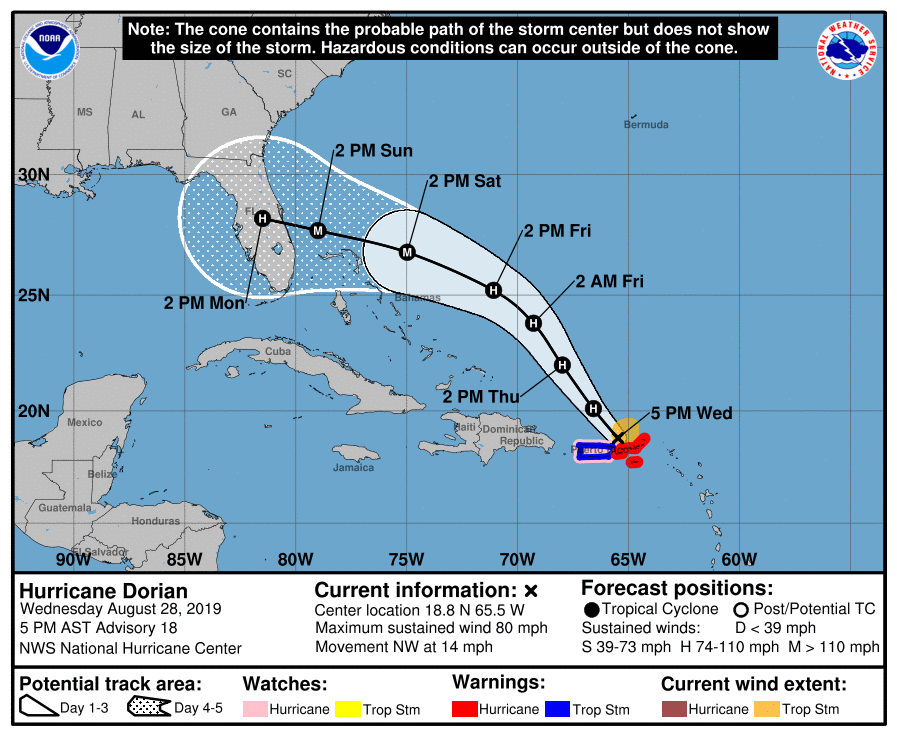
@NASA From my thread at the time (August 28th), the map shown here is the one that he added to in an oval office press conference on September 5th 2021 (Video here >> abc.net.au/news/2019-09-0…), were he added his modified forecast for Hurricane Dorian's path. 

In the press conference where Trump presented his rather comically doctored chart he says: "We got lucky in Florida, very very lucky indeed." Which is true. Especially him personally. abc.net.au/news/2019-09-0…
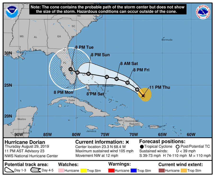
Here we see the track evolution between August 28th and September 1st when the official forecast track finally stayed off the Florida Coast.
Before this course correction for a fairly long period it looked as if there might be a direct hit on Mar-a-Lago [Google maps.. google.com/maps/place/Mar…] 


During a 24 hour window from 11pm on 29th August through 11pm on August 30th Mar-a-Lago was directly in Dorian's crosshairs. 


Here we see a graphic animation of the path of Dorian at this time (I.E. on August 28th). Dorian is moving fast in a very straight line.
https://twitter.com/i/status/1166816502844145665
That said cyclones are tricky to predict and even on August 28th the two major global models were not in agreement, and the European ECMWF model was indicating some kind of turn to the north near landfall..
https://twitter.com/althecat/status/1166819293222322180?s=20
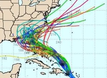
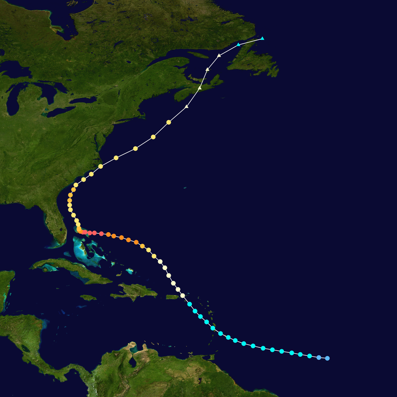
But what actually happened was nothing like either forecast. #Dorian stayed almost exactly on its predicted @NHC_Atlantic trajectory, but slowed down and stopped over the Bahama Islands, where it stayed for several days before turning north.
Here is the forecast path evolution.
Here is the forecast path evolution.
Major Hurricane Dorian, a Category 5 super hurricane devastated the Bahamas and is thought to have killed at 300+ people (75 confirmed 245 missing) and inflicted 3.4 billion USD in damage. reliefweb.int/report/bahamas….
Anyway that is the untold part of the story of the disaster, and here are the new visuals from @NASA each shows visual satellite data and so we only see the storm during daylight hours.
This first one shows the storm on approach. Slowing but not yet stopped.
This first one shows the storm on approach. Slowing but not yet stopped.
This first animation is from Sunday September 1st, the day the storm had been expected to make landfall in Florida. This second animation picks up the path as Dorian makes landfall in the Bahamas and slows down.
And here we see Dorian as he remains stationary for nearly a full day on September 2nd and weakens, losing his eye. Reports during this period from the Island were nearly non-existent as the northern Island group was being battered, especially the area close to the eye wall.
And then finally here we see Dorian finally starting to move again on September 3rd.
At which point it made a 90 degree right turn and headed North instead of West as predicted. In this thread @RyanMaue who is an expert in these things uses the Dorian example to explain the math.
https://twitter.com/RyanMaue/status/1415346408413093895?s=20
Using Ryan's numbers here the placement of Dorian was within statistical expectations (as it was still within the cone - as it stopped, inside the cone for 48 hours.
https://twitter.com/RyanMaue/status/1415348899192221697?s=20
Anwyay inc conclusion:
1. Dorian is a great poster child for the hazards of hurricanes, horrific and unpredictable.
2. Donald Trump was exceedingly lucky that Mar-a-Lago was not damaged in 2019
....
1. Dorian is a great poster child for the hazards of hurricanes, horrific and unpredictable.
2. Donald Trump was exceedingly lucky that Mar-a-Lago was not damaged in 2019
....

.... and 4.
3. His weird press conference on 5th Sept. is understandable given he spent a day thinking his home would be pummelled by the major hurricane.
/ENDS
@Threadreaderapp unroll
3. His weird press conference on 5th Sept. is understandable given he spent a day thinking his home would be pummelled by the major hurricane.
/ENDS
@Threadreaderapp unroll
P.S. here is Trump's full press conference about Dorian, where he presents his modified NHC weather map. [Note its glitchy at the beginning - just wait] c-span.org/video/?463981-…
This is where Hurricane Dorian was when Trump held the press conference, two days after the animations above.
• • •
Missing some Tweet in this thread? You can try to
force a refresh


