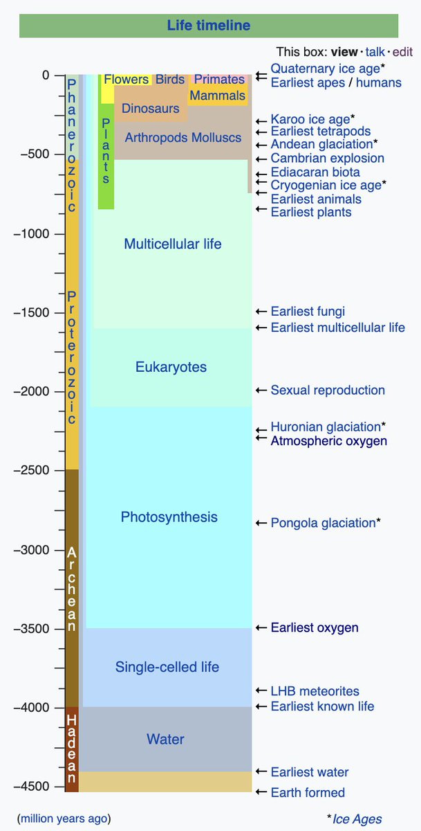
2.4 billion years ago, Earth's atmosphere was free of oxygen. Iron didn't rust! Only anaerobic species could survive.

And then ... cyanobacteria evolved photosynthesis, and began to pump oxygen into the atmosphere.

Oops.

🧵 1/n

#GreatOxygenationEvent

en.wikipedia.org/wiki/Great_Oxi… Image
Suddenly, iron dissolved in the oceans bonded with oxygen and precipitated, forming layers of rust on the ocean floor. The deposits got thicker and thicker, reaching 100s of meters. 60% of iron is mined from these layers! 2/n

#bandedironformations

en.wikipedia.org/wiki/Banded_ir… Image
Methane was no longer stable: it reacted with oxygen to form CO2. Methane is a far more powerful greenhouse gas - so dropping methane levels triggered sudden cooling. The Earth froze over, with glaciers reaching as far as the tropics. 3/n

#snowballEarth

theconversation.com/billions-of-ye…
How do you break out of snowball Earth? Ice reflects sunlight, so with more ice, Earth absorbs less heat. It might have stayed frozen over forever, except that volcanoes kept pumping carbon dioxide into the atmosphere, increasing greenhouse gases. 4/n

en.wikipedia.org/wiki/Snowball_… Image
Oxygen continued to accumulate in the atmosphere, and began to poison the anaerobic bacteria that dominated the oceans.

This was the world's first #massextinction.

5/n

slate.com/technology/201…
A handful of species survived the oxygen and the glaciations. But it wasn't until over a billion years later that these evolved into Earth's first plants and animals. Our ancestors, and those of all life we know today.

6/end Image

• • •

Missing some Tweet in this thread? You can try to force a refresh
 

Keep Current with Dr. Judith Hubbard

Dr. Judith Hubbard Profile picture

Stay in touch and get notified when new unrolls are available from this author!

Read all threads

This Thread may be Removed Anytime!

PDF

Twitter may remove this content at anytime! Save it as PDF for later use!

Try unrolling a thread yourself!

how to unroll video
  1. Follow @ThreadReaderApp to mention us!

  2. From a Twitter thread mention us with a keyword "unroll"
@threadreaderapp unroll

Practice here first or read more on our help page!

More from @JudithGeology

Mar 3
People sometimes talk about how the seafloor is one of the great unexplored mysteries - and it's true - but there's a vast region of land that also qualifies: the Tibetan Plateau. 🧵 1/ Image
Standing at ~4.8 km above sea level (15,700 ft), the Plateau is extremely inhospitable to humans: oxygen is almost halved compared to sea level. Operating at this altitude is difficult: movement is exhausting, thinking is hard. 2/

theconversation.com/how-does-altit… Image
For comparison: the highest peak in the continental US is Mt. Whitney, at 14,494 feet (4418 m).

That's lower than the AVERAGE elevation of the Tibetan Plateau - a region 2000 km x 1000 km! 3/
Read 23 tweets
Jan 25
You might hear a geologist say: "We can't predict earthquakes."

Well, WHY NOT???

1/n

🧵⬇️⬇️⬇️

#earthquake #earthquakeprediction
First, let's define "prediction". A useful #earthquakeprediction will tell you where, when, and how big a significant #earthquake will be, with a reasonably high success rate.

That's different from #forecasting, #earlywarning, and #aftershocks. 2/n

To date NO ONE has developed an effective way to predict significant earthquakes.

Issue #1: Faults are fractal.

"But we know where the tectonic plates are!"

Yes, mostly, but plate boundaries are complicated - see the maps below comparing plates vs. faults. 3/n

#tectoplot
Read 23 tweets
Jan 23
Oh, cool!

Stress is basically how much the rocks are being squeezed, and in which direction. If we can know that, and also know how *strong* the rocks are, we can estimate whether they will break.

But it's super hard to measure... 1/n
When rocks *do* break (#earthquake!), we can use that to estimate stress. If you know the direction of slip, you can do even better. This even works for earthquakes that occurred long ago, if they left scratches on the fault!

rickallmendinger.net/faultkin

2/n
Or, if you have a lot of money and time, you can drill into the Earth and measure the orientation of maximum squeezing based on how the borehole deforms.
#boreholebreakouts

3/n

jgs.lyellcollection.org/content/162/1/… Image
Read 11 tweets
Jan 14
A Mw6.6 #earthquake just occurred below the W tip of #Java, #Indonesia. Here, the Indo-Australian Plate is sinking below the Sunda Plate. To the north, this #subductionzone produced the devastating Mw9.1 2004 Indian Ocean earthquake and tsunami. 🧵1/5

#tectoplot Image
Fortunately, a Mw6.6 is much, much smaller than a Mw9.1 - 5000x less energy! 2/5

earthquake.usgs.gov/education/calc…
The earthquake depth (~35-45 km) is similar to the plate boundary fault, but the focal mechanism shows slip on a steeply dipping thrust fault. This likely represents a hanging wall splay fault, or fracture of the downgoing plate. 3/5

earthquake.usgs.gov/earthquakes/ev… Image
Read 5 tweets
Jan 14
Ever look at global #earthquakes from the top down? The #NorthAmericanPlate and #EurasianPlate seem simple around the Atlantic - they're pulling apart - but if you follow that boundary across the pole to Russia, it gets weird and diffuse. 🧵1/4

#tectoplot Image
#Iceland provides a remarkable view of the plate boundary. Here, the plates are pulling apart over a #hotspot, so the spreading center is on land instead of at the bottom of the sea.

And just look at the result! Pictured here: #LakeThingvallavatn. 2/4

nationalgeographic.org/encyclopedia/r… Image
But follow that plate boundary past the pole and under the ice, and you find yourself in Russia. Suddenly the #earthquakes are scattered and the plate boundaries poorly defined.

There's actually a whole extra baby plate here - the #OkhotskPlate. 3/4

washington.edu/news/2006/05/0… Image
Read 4 tweets
Nov 15, 2021
This is a map of sea level, exaggerated 10,000 times.

Why is it so weird and lumpy? Sea level is not defined by distance from Earth's center - it's an equal-gravity surface.

Understanding the #geoid is key to understanding #climatechange impacts. 1/7

en.wikipedia.org/wiki/Geoid Source: http://doi.org/10.5194/essd-11-647-2019.
The "lumpiness" comes from variations in density and topography. Mountains have gravity, so the #geoid is generally higher in mountainous regions. But inside the Earth there are variations, too - from the different kinds of rocks and the thickness of the crust. 2/7
Elevations on Earth are defined relative to the geoid. So every time you look at a topographic map, there's a secret geoid hidden behind that data! 3/7
Read 7 tweets

Did Thread Reader help you today?

Support us! We are indie developers!


This site is made by just two indie developers on a laptop doing marketing, support and development! Read more about the story.

Become a Premium Member ($3/month or $30/year) and get exclusive features!

Become Premium

Don't want to be a Premium member but still want to support us?

Make a small donation by buying us coffee ($5) or help with server cost ($10)

Donate via Paypal

Or Donate anonymously using crypto!

Ethereum

0xfe58350B80634f60Fa6Dc149a72b4DFbc17D341E copy

Bitcoin

3ATGMxNzCUFzxpMCHL5sWSt4DVtS8UqXpi copy

Thank you for your support!

Follow Us on Twitter!

:(