1/11 #Kherson update 24-08. 🇷🇺 forces attacked in different area's of the front presumably in anticipation of indepence day offensives,in this 🧵 the details.🇺🇦 forces have been attacking supply lines & C&C continuesly last weeks.
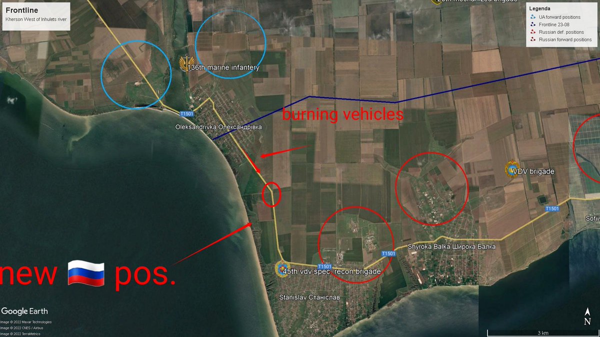
2/11 In the Stanislav area, 🇷🇺 attacked Oleksandrivka some 2 week ago pushing 🇺🇦 back to positions N, last week 🇺🇦 forces countered. 🇷🇺 were pushed back to the S end of town.Burning vehicles have been seen on/near the T-1501 HWY. Town is now contested.
3/11 to the E, 28th mech. Brigade keeps supressing 🇷🇺 artillery in ShyrokaBalka area, 🇷🇺 forces tried to move NW from Sofiivka but where repelled on the line W of Doslidne by forward 🇺🇦 forces.Around Tomyna Balka reportedly multiple MLRS & art. were destroyed by 🇺🇦 artillery.
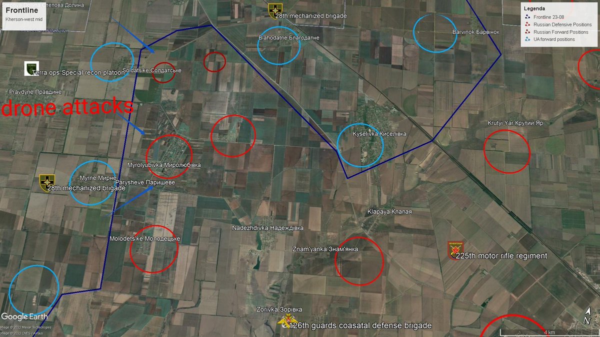
4/11 The line Molodetkse - Myrolyubivka seems static. 🇺🇦 forces consolidated control over Pravdyne, which was hit by 🇷🇺 art. last weekend. 🇺🇦forward positions in Myrne & Paryseve have strengthend. 🇷🇺 in these area's are being harrased by continues drone attacks & art. fire.
5/11 Kyselivka, 🇺🇦 seems to have taken full control of the town,🇷🇺 forces started shelling the town last week.🇷🇺 forces remain entrenched S along M14 HWY. A ctr-offensive was launched toward ZelenyiHay & Barvinok but was repelled by the 🇺🇦 14th Mech division which are dugin there
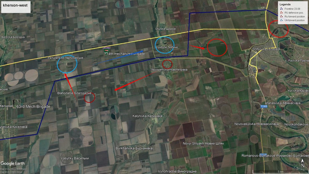
6/11 The situation around Snihurivka is very fluid. Last week 🇷🇺 VDV attacked from there toward Partizanske. It was repelled & 🇺🇦 forces took positions in Luyubine & Shyroke. 🇷🇺 attacked toward Blahodatne en pushed 🇺🇦 forces out using heavy art. & are pushing north to Partizanske
7/11 The area around Partizanske is heavily fortfied along the canal behind the railway slope. Which runs from Pervomaiske to Snihurivka. To the left of Blahodatne the 🇺🇦 63rd mech. Brigade is dugin near Kitneve. Rumor is a 🇺🇦 ctr-attack toward Blahodatne has allready started.
8/11 meanwhile more E Andriivka remains under 🇺🇦 control,the area around Blahodativka stays fluid, last week news appeared 🇺🇦 liberated the town, but 🇷🇺 art. pushed them out again. A push against Sukhyi Stavok failed, but 🇺🇦 forces advanced to 3km from Bruskynske.
9/11 meanwhile 🇷🇺 forces are preparing defenses around the bridges over the Dnipro river aswell as important transport hubs. Trenches & fortyfied areas have been build around, Antonovskyi bridge, Nova Khakova and Molodyzne (road turnpike).
10/11 The 🇺🇦 campaign of destroying 🇷🇺 supply lines & hubs continues with new attacks in Nova Khakova, Chornobaivka and many more places making resupply increasingly difficult. Antonovskyi bridge was hit again a 20m damaged area can be see on the south side on recent sat. images
11/11 important to remember is that many of the towns on the frontline should be considered contested since forces are moved back & forth around by ctr-attacks in these areas .Info used #OSINT,local sources,sat. data.
1/10 #Kherson western front update 🧵is finally here.Been working on checking info from local,#OSINT,sat & other sources to produce the most complete picture IMO while still keeping #Opsec.Let's go 🚀
2/10 First by popular req. a full overview map of the current(8 aug) frontlines west of the #Inhulets river. As we can see there have been some (small) shifts in the overall line. As you can see i have included known 🇷🇺 defensive pos. and some published 🇺🇦 pos. Some details ⬇️
3/10 First we look at the sit. around #Stanislav. 🇷🇺VDV reinforcements arrived 15-7,and started a push toward #Oleksandrivka pushing 🇺🇦 back across the coastal road W and N taking control of the town. 45th Spetnaz are active here. 🇺🇦 are using art. & tank fire to stop the advance
As promissed in my previous 🧵 ⬇️ i will go into the destruction of another ammo depot with #HIMARS in the west-#Kherson region. The one i will take a look at today was located just south of #Novodmytrivka and was hit on 21st of july.
If we look at the #FIRMS data we can see there are a lot of spots on fire around the compound however when looking at the #Sentinel imagery we can see it originates from the N end of the complex and spread on the dry lake bed. This is even more clear using the burned area option.
Burned area option on the #Sentinel imagery makes it possible to see how the fire progressed.We can see spots around the complex which indicates burning material was spread over a large area.This is consistent with a large explosion. (ref. Expl. #Novakhakova 21-7 ⬇️)
Video of 🇷🇺 BM-21 Grad MLRS being loaded & transported to launch site. This recent video published by 🇷🇺 media was supposedly recorded around the town of #Vugledar,#Donetsk oblast multiple launchers can be seen and loading occurs on the road.
At 11 sec. you can see the loaded MLRS driving on a road which bends to the right, in the distance two elec. towers can be seen as well as a field full of powerlines to the left. @neonhandrail geolocated this site. It was geolocated to #Novohryhorivka.
#Vulgledar would have put 🇷🇺 forces atleast 10 km behind the known frontlines in this area.The geolocation however puts it at 23 km away behind 🇷🇺 lines.When we look @ sighting loc. on 22-7 with #Sentinel imagery.we can see the field to the S is burned.
As promissed a 🧵 on what was happening inside #Kherson city yesterday (22-7). I have been in contact some local sources who painted a picture of every growing chaos & fear among 🇷🇺 troops & collaborators inside the city. First it's important to know that during the occupation
The 🇷🇺 invaders have been setting a system of checkpoints on almost any intersection in the city, these are called blockposts by the civilians. Before last week these checkpoints where mostly manned by #Rosgvardiya troops which are a internal mil. force directly under #Putin.
During the last few days,most of these #Rosvguardia seem to have left the city and manning of the checkpoint seemed more lacks. This seems to have increased the number of desertions,farmers in the surrounding areas are being confronted with 🇷🇺 soldiers dressed in civilian clothes
Just a little 🧵 looking at the aftermath of the strike on the ammo depot @ Raiske, Cherson Oblast, Oekraïne which seems to have happend on 18-7 at 5 am.When looking @ the video clearly missiles and thermobaric charges can be seen detonating
At 5 am presumable HIMARS rocket fire hit an ammonutions storage warehouse located at a 🇷🇺 military facility in #Raiske [46.42567 33.18566] seen on sat. images the facility consisted of 6 large warehouses and several smaller structures, just west are an urban area & wheat factory
When looking @ Nasa #FIRMS data from 18-7 it's clear there are mulitiple fires around the south and west sids of town. The fires can be located at 3 places. The first attack hit the ammo storage, fires to E & S were prob. started by exploding ammo & spread thru dry fields.
Yesterday some interesting footage from #Kherson region appeared on telegram showing 🇷🇺 BM-27 #Urugan launchers on the road with the comment that fields were burning around #Chaplynka due to the launches. I decided to investigate here is my little 🧵
On the photo's there are powerlines visible which i was able to locate to being on the road out of #Chaplynka toward #NovaKakhovka. Also a blue sign can be sign which suggests that it just outside of town. When we look at the #FIRMS data however we do not see fires in this area.
When we look at #Sentinel images for 18-7 however we can see a burnt piece of land just NW of this road near the town of #Preobrazhenka. When we go back one day however this piece of land hasn't burned yet. This makes it a likely launching site according to satellite date.