Long post alert
There has been a lot of talk about what is likely to happen for #Chennai and the surrounding districts in the next 4 days.
And it's been a while since I last gave a concrete update and so this I feel is the time to give one
#chennairains #chennaiweather (1/n)
There has been a lot of talk about what is likely to happen for #Chennai and the surrounding districts in the next 4 days.
And it's been a while since I last gave a concrete update and so this I feel is the time to give one
#chennairains #chennaiweather (1/n)
To answer the big question here.
Will #Chennai and surrounding districts get heavy to very heavy rains as being discussed everywhere.
The straightforward answer would be a big "YES".
HEAVY TO VERY HEAVY RAINFALL IS VERY LIKELY IN THE NEXT 4 DAYS FOR CHENNAI AND SURROUNDINGS.
Will #Chennai and surrounding districts get heavy to very heavy rains as being discussed everywhere.
The straightforward answer would be a big "YES".
HEAVY TO VERY HEAVY RAINFALL IS VERY LIKELY IN THE NEXT 4 DAYS FOR CHENNAI AND SURROUNDINGS.
The next question that is being is being widely asked is why?
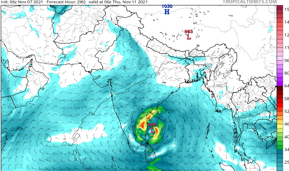
There is a low pressure area that is forming and taking shape in the Central Bay of Bengal region and is likely to move west towards Northern #Tamilnadu coast
It can become a well marked low and at best, a depression
There is a low pressure area that is forming and taking shape in the Central Bay of Bengal region and is likely to move west towards Northern #Tamilnadu coast
It can become a well marked low and at best, a depression
Some rumours are going around that this will be a cyclone.
Be rest assured, this is not a cyclone.
It is only a low pressure area.
The next question that comes to everyone - if not a cyclone, then why will this give rains to #Chennai and surroundings.. ?
Should we worry ?
Be rest assured, this is not a cyclone.
It is only a low pressure area.
The next question that comes to everyone - if not a cyclone, then why will this give rains to #Chennai and surroundings.. ?
Should we worry ?
Low pressure area carry disorganized quadrant of clouds - filled with moisture laden rain clouds.
Cyclones are wind based.
Cyclone na kaathu irukkum.. Depression na mazhai irukkum..
Let us understand this simply as of now.
The next big question is when and how much ?
Cyclones are wind based.
Cyclone na kaathu irukkum.. Depression na mazhai irukkum..
Let us understand this simply as of now.
The next big question is when and how much ?
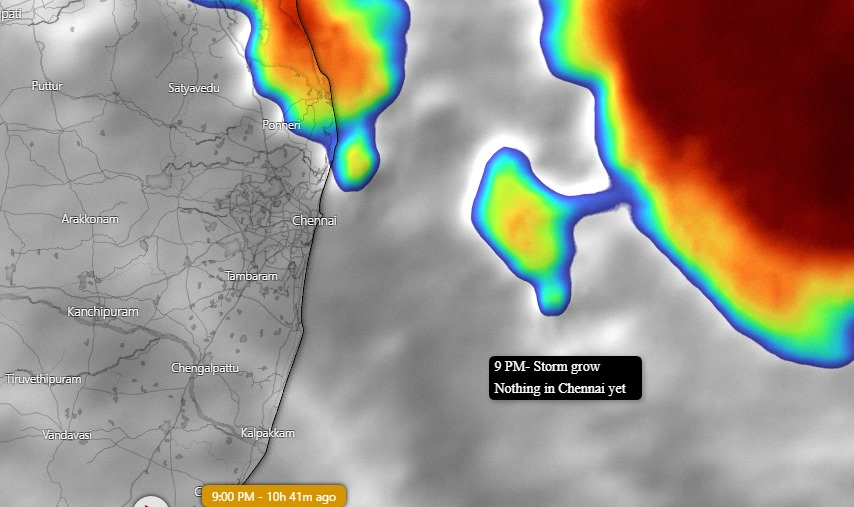
Moderate to heavy rains will start tomorrow evening / night time and continue overnight (10th)
11th and 12th - Heavy rainfall likely to happen in most areas in CTKC areas. Break irukkum.. vittu vittu gana mazhai..
12th I feel there should be some breaks - only for a while.
11th and 12th - Heavy rainfall likely to happen in most areas in CTKC areas. Break irukkum.. vittu vittu gana mazhai..
12th I feel there should be some breaks - only for a while.
I am of the strong opinion - having been tracking this system for good 5 days closely, that the day to look out for is 13th and 14th morning hours.
OCCASIONAL SPELLS OF HEAVY TO VERY HEAVY RAINFALL is likely !
Please be alert especially on these two days !
OCCASIONAL SPELLS OF HEAVY TO VERY HEAVY RAINFALL is likely !
Please be alert especially on these two days !
We will be in a situation that already heavy rainfall would have happened on 11th and 12th.
Rains on 13th and 14th would add more problem to us. Localised Urban flooding is VERY LIKELY.
Rains on 13th and 14th would add more problem to us. Localised Urban flooding is VERY LIKELY.
After 14th afternoon, rains would gradually reduce. Occasional spells would however be possible. On this, we will be closely monitoring and posting in due course.
12th and 13th- Ranipet and Vellore dist. Should also be on high alert along with southern #AndhraPradesh
12th and 13th- Ranipet and Vellore dist. Should also be on high alert along with southern #AndhraPradesh
Many have written to me and have asked how much quantum I'm expecting.
Well I can tell - there will be mazhai after mazhai, exactly to zero in on one number is near to impossible.
If someone is able to do it and has got it correct - Kudos to them. Enakku andha alavu theriyaadhu
Well I can tell - there will be mazhai after mazhai, exactly to zero in on one number is near to impossible.
If someone is able to do it and has got it correct - Kudos to them. Enakku andha alavu theriyaadhu
The school and college leave has been a trend these days. While I am of the opinion that authorities have the right inputs to announce it - my suggestion would be as below.
CTKC district schools and colleges - can be closed from 11th to 14th as a precautionary measure.
CTKC district schools and colleges - can be closed from 11th to 14th as a precautionary measure.
To close this thread,
1. Heavy rains possible
2. Dates : 10th-14th
3. Maximum - Depression only.
4. Be alert for 4 days.
5. Stay home and safe if you can.
6. Exercise prudence wherever you go.
7. Follow official updates from Govt. Agencies regularly.
8. Stay safe and vigilant.
1. Heavy rains possible
2. Dates : 10th-14th
3. Maximum - Depression only.
4. Be alert for 4 days.
5. Stay home and safe if you can.
6. Exercise prudence wherever you go.
7. Follow official updates from Govt. Agencies regularly.
8. Stay safe and vigilant.
#chennairains #Chennai #ChennaiCorporation #chennaiweather #chennaifloods @Collr_Chn @TiruvallurCollr @KanchiCollector @tnsdma @ChennaiTraffic @police_chennai
• • •
Missing some Tweet in this thread? You can try to
force a refresh