Update on weather drama from yesterday.

The weather models now appear confused.

Europe may now have a very wet final 2 weeks of Spring, rather than a very cold one. Question is, how wet? Catastrophically so... or just wet wet. threadreaderapp.com/thread/1384500…
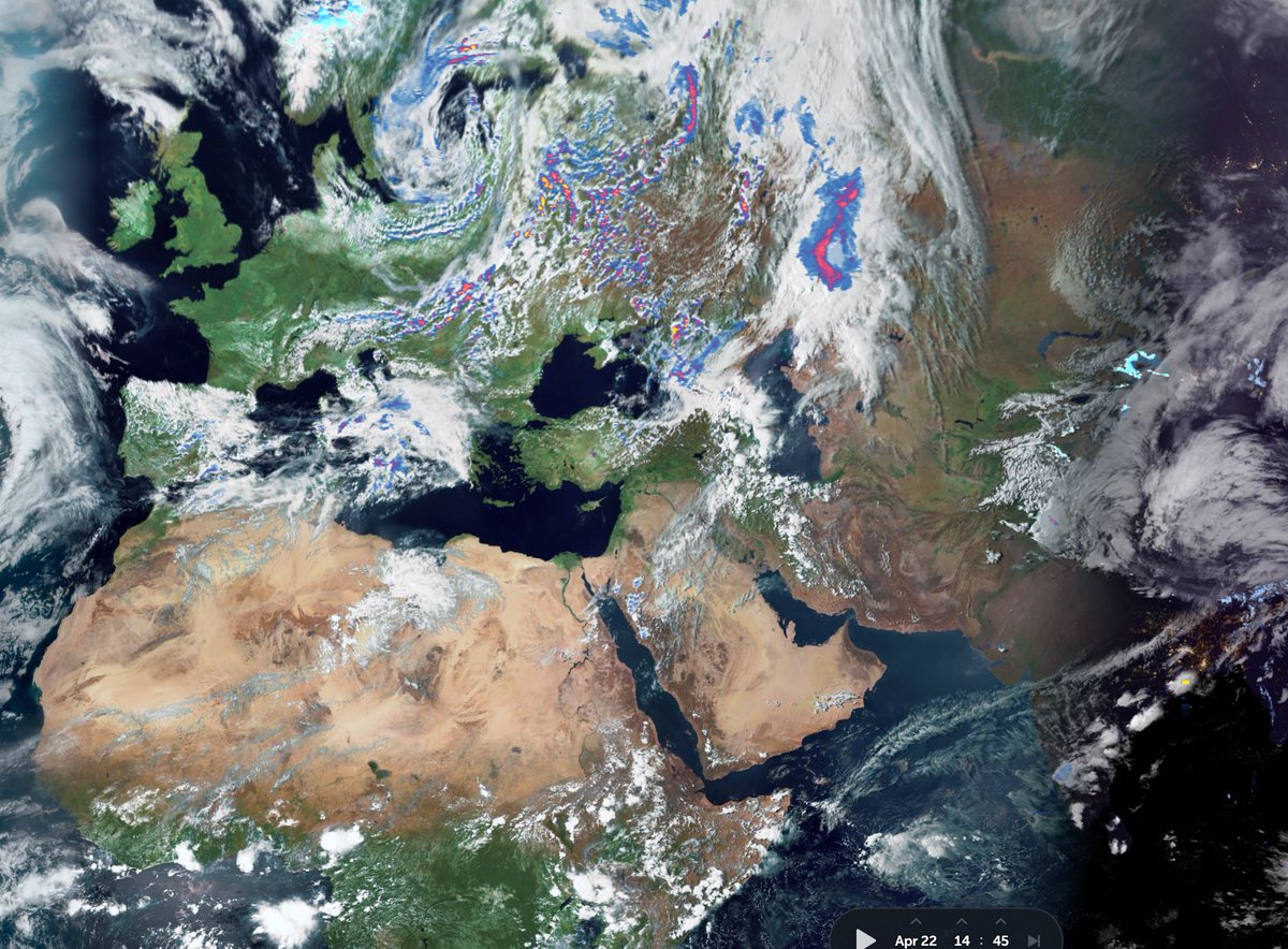
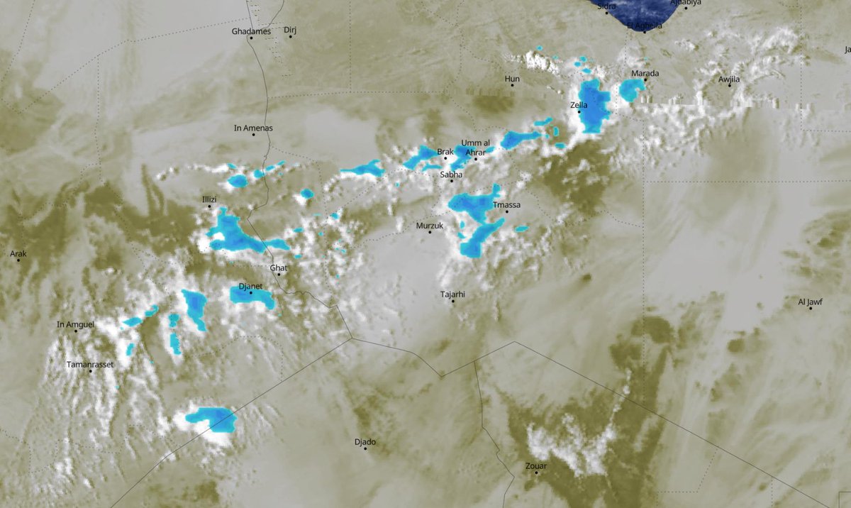
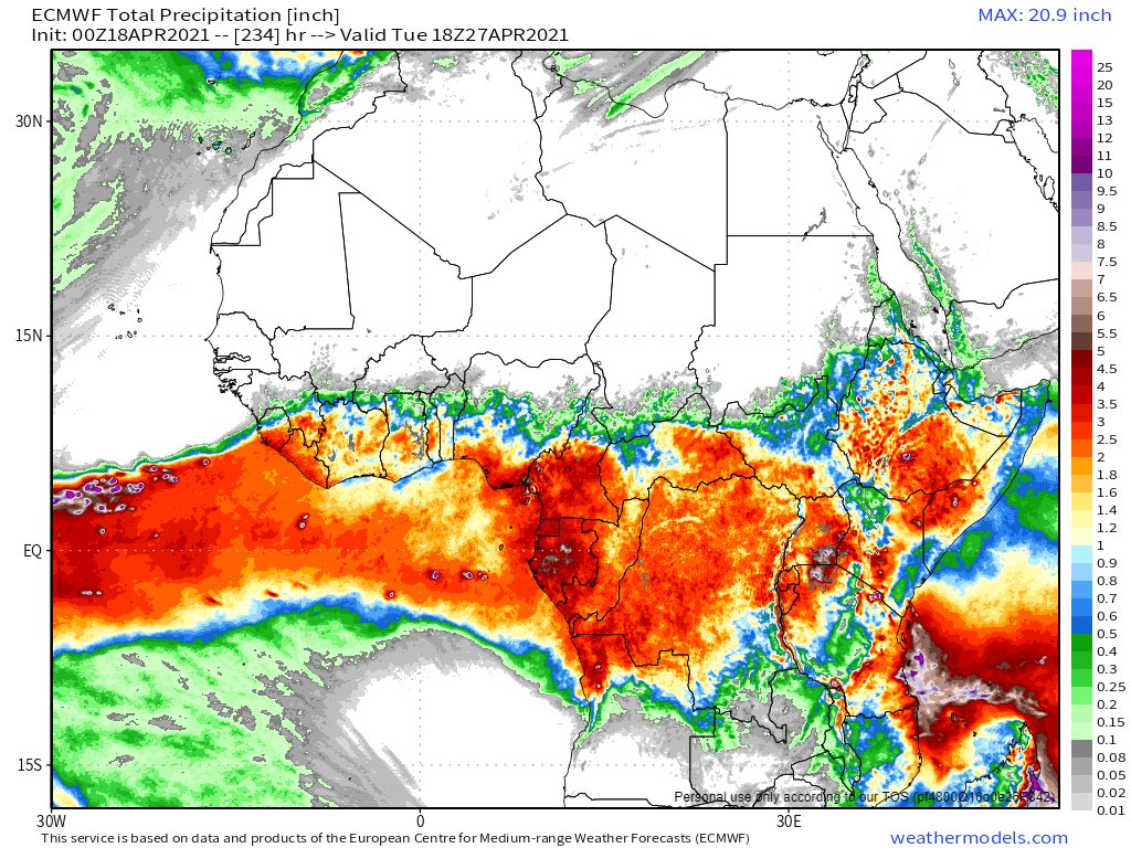
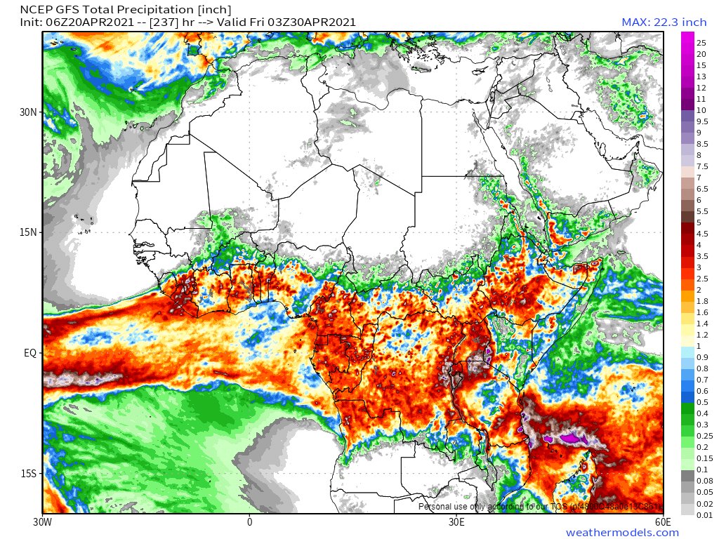
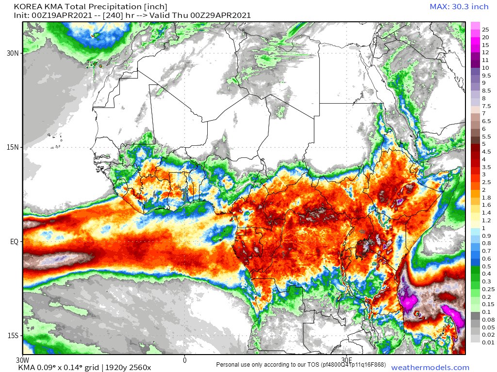
The question posed by the burst of high energy West Africa Monsoon air on Friday which broke the @ECMWF yesterday and surprised the @NOAA GFS today is not related to the actual weather itself.

For 8000 years from 12000 BC to 3000 BC this was normal & Europe didn’t drown. /2
The question posed by this relates to climate change.

The transit of moisture across the Sahara may be a rare event, or it may be the new normal with a stronger WMA. Time will tell. And the weather models will learn.

But it is clear the weather is changing.
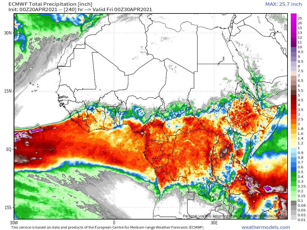
The storms in the Middle East last week, the consequences of this burst of West African Monsoon air and floods in the Nile, the Niger and other African rivers herald massive changes to environments which are home to 100s of millions of people.
This curious failure in forecasting illustrates just how connected we all are.

The cascading effects of a strengthening WAM on the weather in the US (cyclones), Europe (breaking the @ECMWF ) and the ME (storms) are now apparent. threadreaderapp.com/thread/1384469…

• • •

Missing some Tweet in this thread? You can try to force a refresh
 

Keep Current with Alastair Thompson

Alastair Thompson Profile picture

Stay in touch and get notified when new unrolls are available from this author!

Read all threads

This Thread may be Removed Anytime!

PDF

Twitter may remove this content at anytime! Save it as PDF for later use!

Try unrolling a thread yourself!

how to unroll video
  1. Follow @ThreadReaderApp to mention us!

  2. From a Twitter thread mention us with a keyword "unroll"
@threadreaderapp unroll

Practice here first or read more on our help page!

More from @althecat

22 Apr
#DesertRain #ArabianStorms #Ethiopa #Sahara #Russia #Europe Special Satellite Images Report:

Here will find a series images of rain events currently underway in deserts in the East of the Western Hemisphere, as the sun goes down on #EarthDay.

Credits @zoom_earth @meteoblue Image
The thread begins with the mother of all deserts the astonishing Sahara. Here you see an April rain event currently underway in Algeria and Libya. #Sahara #DesertRain #EarthDay21
Here are close up images of the Libya/Algeria #DesertRain now traversing the dryest parts of the Sahara. The 1st image (zoom.earth/#view=30.2,17.…) shows rainfall signatures. The 2nd tracks the tail of this rain event back to the Atlantic coast 4500 kms to the West. #EarthDayAfrica ImageImage
Read 16 tweets
21 Apr
21st April 2021 - Middle East #ArabianStorms rainfall forecast update:

10 day forecasts from the GFS, CMC, KMA and GEFS models. /1 ImageImageImageImage
21st April 2021 - 3 day rainfall forecasts from the same models - to midnight Friday. ImageImageImageImage
21st April 2021 - long range rainfall forecasts into next week (16 days to midnight Thursday) from the GFS, GEFS (ensemble) and KMA (12 days to midnight Sunday) models. #ArabianStorms

الله يعلم ImageImageImage
Read 5 tweets
21 Apr
Ethiopia forecast rainfall update: 21st April 2021

GFS, KMA and ECMWF Model forecasts - all 10 days.

NOTE: There is a significant increase in expected rain over the 10 day period compared to forecasts from earlier in April. ImageImageImage
Here is an animation from this afternoon of rain cloud formation over the Blue Nile Basin today. It is picking up speed.
And here is an animation of an explosive burst of convection south of Mogidishu in Somalia. In 5 hours the storm had grown to be larger than the island of Ireland.
Read 4 tweets
20 Apr
The North Atlantic is mounting a come back to this Spring is over in Europe malarkey. /1
It certainly looks and feels like it’s going to rain here. And Andre our 93 year old neighbor reckons a storm is coming.
Ouch.... hopefully not this storm.

I think the weather models may be getting a bit discombobulated what with all this new variability going on.
Read 10 tweets
20 Apr
I seriously think the @ECMWF West African Monsoon simulation model is simply broken. Every day the 24 hour it looks the same. Very loopy.

Here are the GZ 20.00 19.00 18.00 and 17.00 model runs for 10 days accumulated precipitation.
GFS same four runs...
KMA same four runs...
Read 7 tweets
20 Apr
@MostafaELShakaa The fact of the matter is nobody knows how much water will flow down the Nile this year. Only God knows & there may be a lot more than 85 BCM. Last year and 2016 saw flooding. This year's West Africa Monsoon (WMA) looks unusually strong.
@MostafaELShakaa The small rainy season started on Ramadan, April 13th and rains have been steadily increasing.

Today's forecasts (10 days of accumulated Rain) for the Horn of Africa are below from the EU/US and Korean weather models. These show very strong rainfall.
@MostafaELShakaa In response to your April 1st tweet. Ethiopia does not want to take any water from Egypt. It simply wants to generate electricity from it before it leaves Ethiopia. The storage capacity of the GERD will likely improve Egypt's ability to utilise Nile flow as it will make it even.
Read 7 tweets

Did Thread Reader help you today?

Support us! We are indie developers!


This site is made by just two indie developers on a laptop doing marketing, support and development! Read more about the story.

Become a Premium Member ($3/month or $30/year) and get exclusive features!

Become Premium

Too expensive? Make a small donation by buying us coffee ($5) or help with server cost ($10)

Donate via Paypal Become our Patreon

Thank you for your support!

Follow Us on Twitter!