#Hailstorms in Various Parts of #Haryana today on 25th February.
Major damage to standing Rabi crops in the state, Farmers reporting upto 100% Crop damage in some areas.
This Video is from Singhani, Tehsil Loharu District #Bhiwani
Thread of HailStorm videos from Diff locations 👇
Bhuna #Fatehabad
Video Sources are from Farmers Groups and are verified.
Also verified on our end by cross checking through Radar imagery and Real time Storm tracking. @LiveWxIndia
(5/n)
• • •
Missing some Tweet in this thread? You can try to
force a refresh
Winter rains and first spell of #Coldwave ahead for North India.
A western disturbance to affect north India on Sunday afternoon - Monday afternoon with peak during Sun evening - late night.
It will bring spell of moderate #snowfall over #Kashmir, #Himachal & #Uttarakhand 1/4
In Plains, Fairly widespread moderate rains/thunderstorms are expected in #Punjab #Chandigarh north #Haryana during Sunday aftnoon - late night
Remaining parts of Haryana and #Delhi NCR to experience scattered light/ moderate rain during Sunday night. A few areas May miss out 2/4
Season's first #Coldwave loading 🥶
Icy cold winds from snowclad Himalayas to bring significant drop in temperature next week, minimums are predicted to record in the range of 2-5°c in #Punjab #Haryana north ##Rajasthan, While #Delhi #UP to record in 5 to 8°c range! 3/4
#India to experience a very wet phase of weather, usually cool temperatures in the next 10 days with no seasonal #Heatwave which usually strengthen around this time.
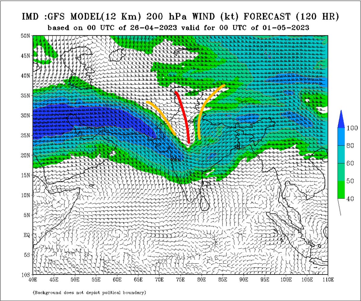
A Typical Jan/Feb standard WD is approaching (200 hpa Jet streams dipping too south + CC developing)
1/n
Dipping Jet/WD approaching North India + Lower level Cyclonic circulation developing in the plains, Wind discontinuity over central India along with moisture incursion from the seas.
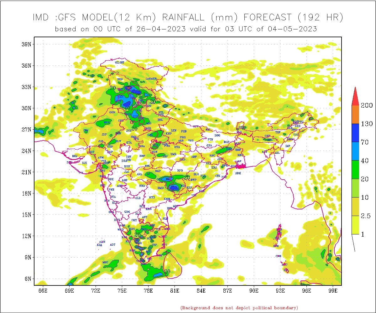
- Scattered #Duststorm and rains to pick up in North #India from 27th April i.e tomorrow
Unseasonal rains to impact pan #India 15th March onwards.
• Abnormal dip in the westerly jet stream up to the southern peninsula to trigger back to back WDs.
• A lot of wind instability on lower levels with (CC/LPA/LWD) to form up with moisture aid from BOB & Arabian sea. 1/n
Impact (13-14th March)
Under the influence of weak WD isolated thunderstorms to form up over #Punjab, #Haryana#Chandigarh#Delhi NCR, #HimachalPradesh, #Uttarakhand in the late afternoon - night hours on 13th & 14th march, coverage will be highly localised (25% areas) 2/n
After 15th March the key weather features will develop and lead to a sudden change in weather conditions across #India.
Intense #Thunderstorm, #Rains, #Hailstorm and strong winds to affect most parts of south, east, central and north India with peak intensity during 16-20th. 3/n
IMPORTANT Weather update for #Delhi NCR/ North India!
Rains picked-up in Delhi NCR since yesterday with very heavy rains today, places in south Delhi, #Gurgaon#Faridabad crossed 100mm rainfall mark till 8:30PM
Conditions worsen further till weekend. #DelhiRains
Thread👇
Synopsis:
• A stable/ Re-curving low pressure area + monsoon axis will hold around West #UttarPradesh/South #Haryana for next 3 days.
• WD trough on upper levels restricting further west movement leading to slow curve making it a steady and compact Wx system.
Impact 👇
Heavy to very heavy rains likely to continue in #Delhi NCR, #Haryana#Chandigarh West #UttarPradesh, East #Rajasthan for next 3 days (Friday - Sunday).
Various parts to receive broadly 200-400mm rains in this period, Close half of the year's normal for a few stations. 3/n