
#Ethiopia #NorthAfrica #MiddleEast long rang rainfall forecast bulletin 2022 - #1
Around this time last year I began posting rainfall forecasts for East Africa & Horn of Africa. These expanded to include North Africa & ME.
I am restarting them today.

Around this time last year I began posting rainfall forecasts for East Africa & Horn of Africa. These expanded to include North Africa & ME.
I am restarting them today.
https://twitter.com/althecat/status/1381633036379426820?s=20&t=O39VWN_LEBgjcgmil7mrLQ

The big picture. The West African Monsoon is undergoing an intense period and significant amounts of atmospheric is transiting the Sahara bringing clouds & rain to the Middle East.
Rain forecasts for East Africa show significant rain over the coming fortnight.
Rain forecasts for East Africa show significant rain over the coming fortnight.

Sub thread: Covers the past two weeks as West African Monsoon was building. Interestingly the rains appear to be arriving in the Horn and East Africa at roughly the same time, and at similar intensity to last year.
https://twitter.com/althecat/status/1514263245175103492?s=20&t=tXUgMkemF31VhA2CXU8-OQ
This week's rainfall forecasts will begin in Ethiopia - here is a satellite view of the 24 hours till about 6pm EAT. Again we can see the storm clouds forming along the line of the edge of the Rift Valley.
Here are rainfall forecasts from April 2021 - each showing model forecasts from the GFS model for rain accumulation over 10 days from the 9th, 10th and 11th of April.


And these are today's model forecasts for the Horn from the:
1. ECMWF 10 days
2. GFS 10 days
3. KMA 10 days
4. KMA 12 days
... Models.
#Ethiopia #Sudan #Somalia #SouthSudan
1. ECMWF 10 days
2. GFS 10 days
3. KMA 10 days
4. KMA 12 days
... Models.
#Ethiopia #Sudan #Somalia #SouthSudan


From a little further south here are are 10 day rainfall model forecasts for #Kenya, #Uganda and north #Tanzania from 1. ECMWF and 2. GFS.


Here is the rain accumulation simulation animation in 12 hour intervals from the ECMWF model. Many of these areas are desperately needing rain.
الله أعلم
الله أعلم
Here are some high resolution satellite images of the region from today.
1. Afar
2. Horn of Africa
3. GERD to Lake Tana
4. Lake Victoria.
1. Afar
2. Horn of Africa
3. GERD to Lake Tana
4. Lake Victoria.


And a long image... following the White Nile from Lake Victoria north to Khartoum.

We will now move to look at the bigger picture. Here we see the West African Monsoon (right) and on the left the North Amazon which is sending an atmospheric river of water back north eastwards over the Sahara.

In this animation you can see the flows of water moving in both directions over the Tropical Atlantic.
This animation shows the Eastern end of that Amazon sourced plume of moisture over the Great Saharan Desert.
This level of cloud activity over the Sahara is as I recall significantly more than what we were seeing this time last year.
This level of cloud activity over the Sahara is as I recall significantly more than what we were seeing this time last year.
This animation shows a 10 day forecast of atmospheric water vapour over North Africa. Through to April 24th.
Again the intensity of the precipitable water concentrations over the Sahel appear to be more intense than at this time last year.
Here we see the major source of water incoming to the Horn of Africa - flows coming in from convection in the Ocean West & South of India.
Here we see the major source of water incoming to the Horn of Africa - flows coming in from convection in the Ocean West & South of India.
Here are the 10 day model forecasts for North Africa.


And longer range forecasts for North Africa.
1. 15 days (EPS - ensemble)
2. 16 days (GFS)
3. 12 days (KMA)
This looks like a lot more rain than we saw in forecasts this time last year, especially over the Middle East.
1. 15 days (EPS - ensemble)
2. 16 days (GFS)
3. 12 days (KMA)
This looks like a lot more rain than we saw in forecasts this time last year, especially over the Middle East.


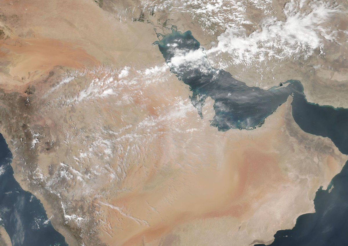
And we now move on to the Middle East - here's a satellite image from this morning.
This animation (also today) shows a fairly consistent phenomena which we saw through the winter, January and February especially. A combination of Amazon sourced jets from the West and water transport moving north over Ethiopia and North East from the CAR over Sudan.
Finally in this Middle East introduction - 2 16 day forecasts - here we see PWAT (Precipitable Water Vapour) over the region over the coming 16 days.
This corresponding #MiddleEast IWVT plot shows the forecast intensity of aerial water flows over the region over 16 days. Each frame shows water flows in kgs per meter per second - the flow directions - and pressure contour lines.
Here are model accumulating rain forecasts from four models of the next 10 days for the #MiddleEast.
We didn't see anything like this in the forecasts this early in the year in 2021.
We didn't see anything like this in the forecasts this early in the year in 2021.


And here are four longer range forecasts 12-16 days. These suggest significant rainfall over the Arabian Peninsula.


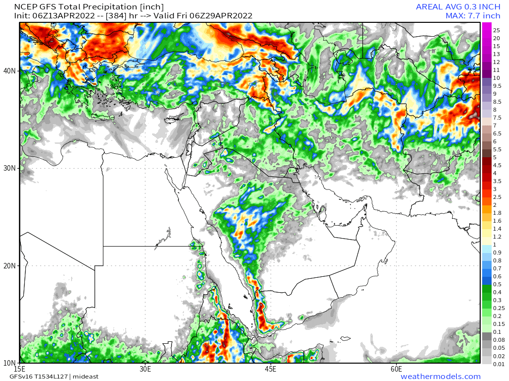

April is the wettest month in Saudi Arabia's capital Riyadh, which is somewhere under that large area of forecast rain area.


This GFS accumulating rain animation - each frame one day - suggests there will be rain over Saudi Arabia for 14 out of the next 16 days.
الله أعلم
الله أعلم
The bulk of the rain is forecast to fall between the 20th and 24th of April next week. Here is the current forecast IWVT plot for that period.
/ENDS
@Threadreaderapp unroll
@Threadreaderapp unroll
• • •
Missing some Tweet in this thread? You can try to
force a refresh


