Rains over the #HornOfAfrica are back to monsoon level, and the heavier rains are forecast to remain for at least a fortnight.
This week's rainfall forecasts for #HornOfAfrica, #NorthAfrica and the #MiddleEast follow.
This week's rainfall forecasts for #HornOfAfrica, #NorthAfrica and the #MiddleEast follow.
https://twitter.com/althecat/status/1441758552452857864
Today's forecasts big picture is of the view from above of North Africa, The Middle East, The Horn of Africa India and southern parts of Europe and Central Asia.
Ethiopia's @DemekeHasen has just started speaking to the #UNGA on behalf of the peoples of Ethiopia.
Ethiopia's @DemekeHasen has just started speaking to the #UNGA on behalf of the peoples of Ethiopia.

Here's a picture of Ethiopia's Deputy PM and Foreign Affairs Minister @DemekeHasen.
You can watch the video of his address here >>
Here's a picture of the Ethiopian delegation.

#UNGA #UNGAEthiopiaCrisis
Well that statement from @DemekeHassan was great. Concise, clear and dignified. I hope it was heard.
Now, back to the rain. Here's a picture of North Africa from this evening. Note the pattern of rain extending deep into the deserts of Sudan and KSA.
Well that statement from @DemekeHassan was great. Concise, clear and dignified. I hope it was heard.
Now, back to the rain. Here's a picture of North Africa from this evening. Note the pattern of rain extending deep into the deserts of Sudan and KSA.

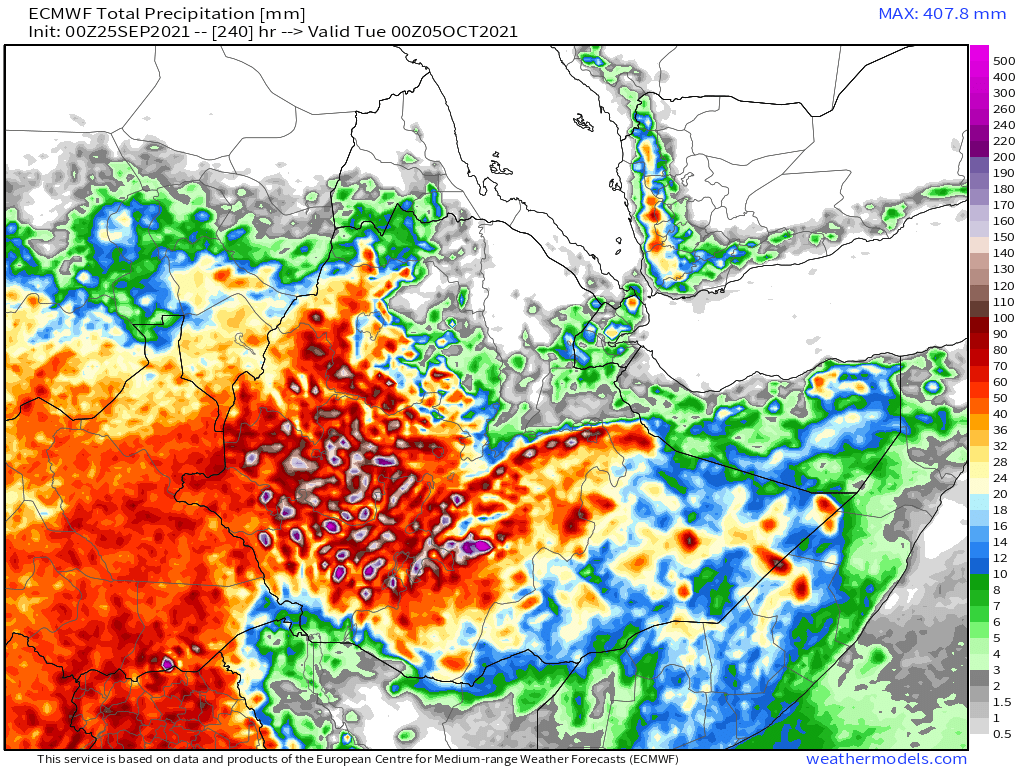
Here we have four model forecasts for the next 10 days of rain. Rain is forecast over the Sahel and nearly all of the #HornOfAfrica during this period. This is due to a late season monsoon burst which is currently building over India.


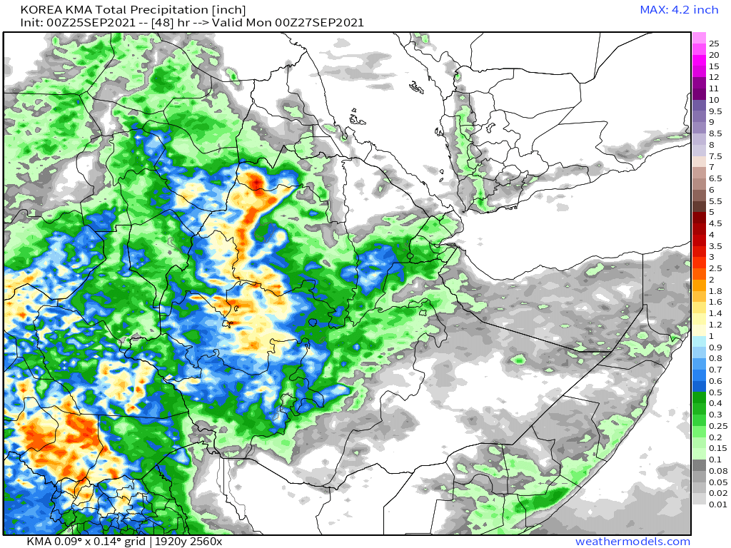
Here we see 48 hour rainfall forecasts from the same four models, the CMC (Canada), GFS (US), KMA (Korea) and ACG (Australia).


And finally, here are the two longer range models, which include the full impact of the monsoon burst. F
1. The GFS 16 day model.
2. The KMA 12 day model.
1. The GFS 16 day model.
2. The KMA 12 day model.


This satellite image, also today, includes an important new feature which appeared this morning in the top right, a small area of intense convection over the Northern Arabian Sea south of Pakistan.

Here we have three 10 day rainfall forecasts for the Horn covering Ethiopia, Eritrea, Somaliland, Somalia, Djibouti, southern parts of Sudan, eastern parts of South Sudan and South Western parts of Yemen.
In three of these forecasts the rainfall covers almost the entire region.
In three of these forecasts the rainfall covers almost the entire region.


And here we have three 48 hour forecasts from the ECM (EU), GFS (US) and KMA (Korean) models.


This is a closeup animation, 24 hours, of the area of disturbance in the Arabian Sea which was briefly designated as an area of interest by the global cyclone monitoring network (the purple line).
This morning when this appeared I posted a small thread about this. And between midnight and 6am (UTC) the GFS global weather model significantly adjusted its forecast on the basis of its appearance.
https://twitter.com/althecat/status/1441720083596861445?s=20
This is the most important tweet in that thread. And it represents the initial re calibration of the GFS model based on this observation. As this is long range and cyclones are very unpredictable it will likely change, but so far the forecast holds.
https://twitter.com/althecat/status/1441752562164699138?s=20
Here's an older view of the same data but looking at it from an Indian Ocean wide view.
These plots show precipitable water [airborne water vapour]. B ecause water has mass, in physics terms this roughly speaking equals energy/potential for rain].
These plots show precipitable water [airborne water vapour]. B ecause water has mass, in physics terms this roughly speaking equals energy/potential for rain].
https://twitter.com/althecat/status/1441463882359267335?s=20
This was before that pop up storm appeared. After the pop up storm appeared the model started predicting cyclones. Two of them.
These two cyclones are highly speculative at this stage. And they appear to arise after the Cyclone Gulab weather system, which is currently over the Bay of Bengal crosses India and emerges into the Arabian Sea.
Here's a picture Cyclone Gulab's forecast track this evening.

Which brings us to the rainfall forecasts for the Middle East. First we have four 10 day rainfall forecasts.
Of these only the GFS and CMC models have forecasted landfalling cyclones.
Of these only the GFS and CMC models have forecasted landfalling cyclones.


Next four 48 hour forecasts, which show all show relatively minor rain over the Arabian Peninsula in the short term.


And finally we have four long range forecasts.
1. KMA 12-Day
2. GEFS (US ensemble) 16 Day
3. EPS (EU ensemble) 15 Day
4. GFS 16-Day (same as the animations earlier)
1. KMA 12-Day
2. GEFS (US ensemble) 16 Day
3. EPS (EU ensemble) 15 Day
4. GFS 16-Day (same as the animations earlier)


At this point talk of cyclones is highly speculative as their existence is still some time away. I will be monitoring this closely and posting the latest data and observations.
That said the overall pattern, from an energy perspective is unlikely to alter significantly in magnitude and there is a lot of water heading towards East Africa.
Where that arrives and in what form is yet to be determined. But something is going to happen.
Where that arrives and in what form is yet to be determined. But something is going to happen.
• • •
Missing some Tweet in this thread? You can try to
force a refresh