Volume increasing (at least on local news) from frustrated residents of South Florida’s flooded neighborhoods. I can refer you to my timeline for previous posts on this matter, but let me summarize again:
(1) no system is designed to absorb 18 inches of rain in a day
(2) Granted, some flood mitigation is possible. I said mitigation, not elimination. E.g. the C-4 Basin in Miami-Dade put in place after the 2000 No Name Storm. And pumps. These things cost big big bucks. Meaning higher taxes. So people against higher taxes can’t have it both ways
(3) This particular event had a 1% chance of occurring in any year. But we’ve had many 1-in-100 year events just over the course of the last 25 years. Statistics are static and don’t incorporate the changing dynamics being driven by #ClimateChange
3/
(4) Recent research from U of Miami shows that heavy rain events during South Florida’s fall — including those outside of rainy season — are increasing. Authors cite warmer seas driven by #GlobalWarming
(5) Indeed, 3 feet of rain has fallen since the start of “dry season”
4/
(6) The water table was already very high because of the excessive rains in recent weeks. Even without excessive rains, the water table is higher today because of sea level rise driven by the #ClimateCrisis. Sea levels are up a *half-foot* at Miami’s tidegauge just since 1995
5/
(7) The chronic sewer pipe breaks in #FtLauderdale? Yes, old infrastructure. But also the bottom of these pipes aren’t sitting in dirt, they’re sitting in waterlogged mud due to the higher water table due to #SeaLevelRise.
6/
(8) Everything predicted by scientists decades ago is coming to fruition. And I would argue, it’s not happening in slow-motion as pundits sometimes say. It’s happening quick, and people are noticing. Property values where sunny-day floods happen are under pressure, as per studies
(9) It’s hotter (duh). When it’s dry droughts happen faster. When it’s wet, it’s excessively wet with stronger downpours. Sea level rise isn’t just underway, it’s accelerating. A greater percentage of all tropical cyclones worldwide reaching catastrophic category 3-4-5.
8/
(10) Bottom line, we (yes, we) love South Florida because of the beauty, the weather, the multiculturalism, and the cosmopolitan stature our cities have attained. I’m not advocating for us to run away from all this. But we need to be aware of these changes, and plan accodringly.
(11) Because people keep moving here, there will be tremendous pressure to continue to build and expand the sprawl. Officials face difficult choices to insure *any* new development makes sense, doesn’t contribute to the problem, and is resilient to increasing threats.
10/
(12) For those of us already here, I’m not urging you to run away. But you must be aware that living here will continue to become more difficult in years and decades ahead. Our lifestyle *and* our pocketbook is affected. We live in a global epicenter of the #ClimateEmergency
fin
• • •
Missing some Tweet in this thread? You can try to
force a refresh
The dry air from the upper level low has arrived, while wind shear and land interaction impact the storm. The storm is, at least for now, weakening. Tellingly, the Hurricane Watch for South Florida has *not* been upgraded to a Warning.
1/
Models, which have now benefited from 2 surveillance missions from the G-IV jet sampling the environment on 3 sides of Eta, have joined the anticipatory Euro which was calling for a hard-left out of Cuba. While that turn has yet to happen, Eta is slowing — a sign of imminent turn
As a result, NHC has pushed their forecast track south yet again — now showing the center passing 94 miles away from Miami and making landfall as a robust tropical (or subtropical) storm in the Lower Keys very late tonight. On the map, blue depicts the Tropical Storm Warning
I’ve been answering everyone individually but let’s do a shutters post for all. Shutters are generally required for winds in excess of 105 mph, which are the ones that can lift non-aerodynamic objects like roof tiles and such. Eta is forecast to be a 70 MPH tropical storm
1/
Now, that’s not to say that there isn’t an outside chance that it will become a Cat 1 hurricane and — this is important — *sustain* that intensity through Monday. So, let’s consider a reasonable worst case scenario. Conveniently, @NWSMiami does that for us.
2/
@NWSMiami This is considered a scenario that has a 10% chance of occurring. It shows hurricane winds for coastal #Miami-Dade east of I-95 or US-1 and the Upper Keys. There’s a 90% chance that it won’t happen, and anything stronger isn’t in the cards according to the experts.
3/
Tropical Storm Warning posted for South Florida and the Keys.
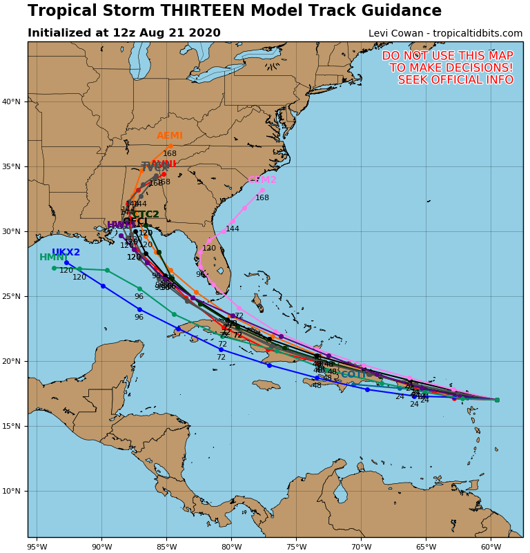
Forecast track for Eta as a robust tropical or subtropical storm nudged northward to the Upper Keys and south Miami-Dade with the latest NHC advisory. The Euro and Japanese models only holdouts showing FL Straits
The intensity forecast from NHC has remained unchanged over the last several advisories. It is more aggressive than the model forecasts, which, eyeballing it, average to a ~50 MPH max wind storm. However, given the track adjustment, chances for storm-force winds increased.
Major changes in the last 12 hours: A new center of circulation has formed in the depression, and 45 mile per hour (75 km / hr) winds were detected in what is now classified as Tropical Storm #Laura.
This new vortex location, no less than 70 miles south of where the National Hurricane Center (NHC) had estimated it was located, puts the Leeward Islands, Virgin Islands, Puerto Rico and the Dominican Republic in play.
2/
Tropical Storm Warnings will likely be issued at 11 AM for everyone, with the possible exception of the Dominican Republic where they may start with a Storm Watch first. In other words, it is now much more likely that storm winds will be felt…
3/
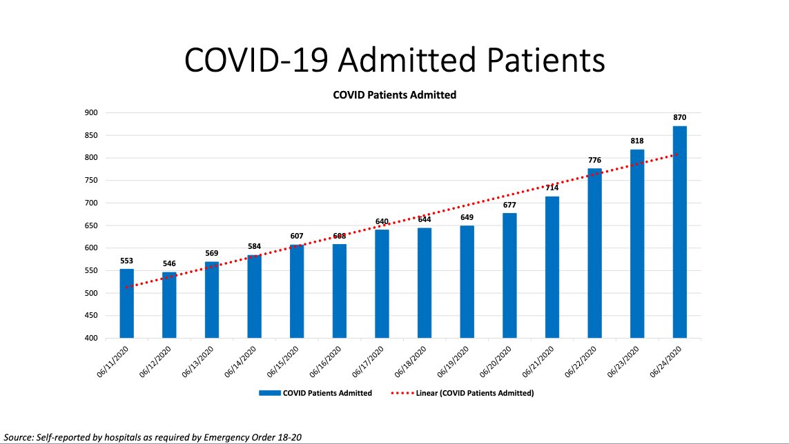
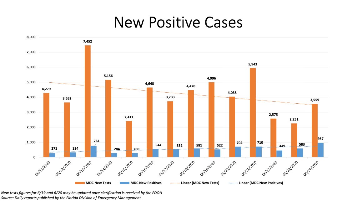
Florida and the U.S. both set new records for #COVID cases today. Higher than March, higher than April. The highest it’s been. Yet I have a *select* few followers from South Florida who call me a fear-mongerer for sharing these facts. Let’s review their arguments:
1/
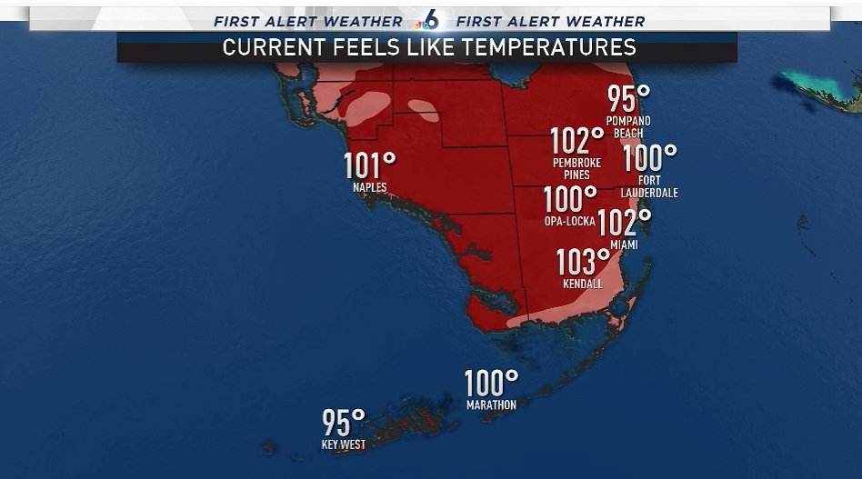
Dumbfounded. Stunned. Astonished. @AngieNBC6@SteveMacNBC6 and I are on conference readying today’s @nbc6 weathercasts and we’re overwhelmed by the sheer number of crazy heat records falling like flies here. This is July weather in April. First, here are current heat indexes.
90°+ days in 2020 up to this date = new record of 8 (previously 6)
75°+ nights in 2020 up to the date = new record of 17 (previously 16)
Earliest hottest weather of the year record has been set 3 times
Earliest 4 straight nights at 78°+ = new record by over 2 weeks (2017)
2/
19 heat records in 8 days collectively for #Miami, Fort Lauderdale and #KeyWest
Ratio of record heat to record cold in #Miami so far this year is 21-0
I stopped counting but up to February Fort Lauderdale had 120 record hot temperatures without a single cold record since 2015.