The interconnections between global weather systems is becoming a trend of a fascinating voyage of metereological discovery that started in The #WestSahara in March, moved focus to #Ethiopia and #ArabianStorms in April and has now widened to include Europe and India. 


Around lunch I did a wrap up thread about #EuropeanStorms activity caused by Round 1 of the #WestAfricaWaterPlume.
https://twitter.com/althecat/status/1388752970582474752?s=20
And to see what happened in Round 1 yesterday, this thread is the best place to start.
https://twitter.com/althecat/status/1388420393741037568?s=20
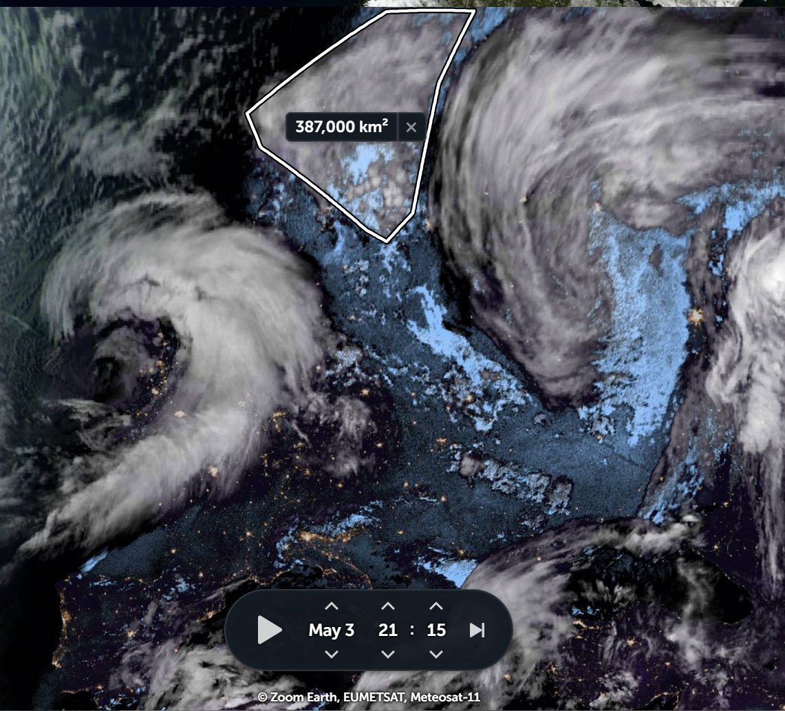
The events in Europe yesterday resulted in a fairly large #ArabianStorms event in the #MiddleEast this afternoon which was not forecast.
It started midway between a line of storms across Iran and a strengthening rain laden stream crossing Yemen.
It started midway between a line of storms across Iran and a strengthening rain laden stream crossing Yemen.
Here's a closeup of the storm's early formation. Which to me looks delightfully whimsical.
Four hours later the #ArabianStorm complex covered an area around the size of Italy. In the top left of the image you can see what most likely helped it to grow so fast. Incoming moisture coming in hot from the north.
Here is another view of this, the storm Gulf storm is bottom right. The moisture is part of the right hand plume identified in yesterday's thread - which spun north towards southern Germany whilst making a sharp turn southwards - initially making landfall in Egypt.
Here's a view of this rapidly turning easterly arm of the #WestAfricaWaterPlume from last night.
Since then the #WestAfricaPlumeEvent has evolved considerably,
Since then the #WestAfricaPlumeEvent has evolved considerably,
https://twitter.com/althecat/status/1388522331874729987?s=20
Here we see the picture from mid afternoon today. The #WestAfricanWaterPlume has become a multitude - with the strongest river in the far west. Many of the plumes are only becoming visible once they get close to the Mediterranean.
This animation shows the plumes in greater detail.
The plumes seem to operate in bursts, and the significant ones are those at the far right. This picture shows the scene as of 30 minutes ago.
The main feature is the big area of clear air in a roughly square box from the Adriatic Coast to Greece heading North East.
The main feature is the big area of clear air in a roughly square box from the Adriatic Coast to Greece heading North East.

Compare the position of the storm in the attached tweet - the one over France [
That storm is doing a consistent 100kmph. As is the main body of the plume.
https://twitter.com/althecat/status/1388528636622426115?s=20] from 24 hours ago, with where it is now. About to be pushed across the Baltic into #Sweden.
That storm is doing a consistent 100kmph. As is the main body of the plume.

The next three animations follow the progress of the main plume bulldozer, which is proceeding almost precisely as forecast for today.
Here we see 9am to 12pm.
Here we see 9am to 12pm.
This animation picks up from 12pm and takes us through to 3pm.
And this one to 5.15pm.
The leading edge of what I am calling the Polish Storm is now over the Baltic. And as its development and position was well forecast we can perhaps see where it is going...
This forecast has the storm near Moscow tomorrow night & an Atlantic storm in the UK at the same time.
This forecast has the storm near Moscow tomorrow night & an Atlantic storm in the UK at the same time.
This images are the CMC (left) and ECMWF (right) precipitable water forecasts for 6pm tonight. They are both very good. 


And here are the two forecasts for 6pm tomorrow. Unfortunately the low systems being produced by these bursts of African water are fairly consistently bringing cold Arctic air South. 


• • •
Missing some Tweet in this thread? You can try to
force a refresh


