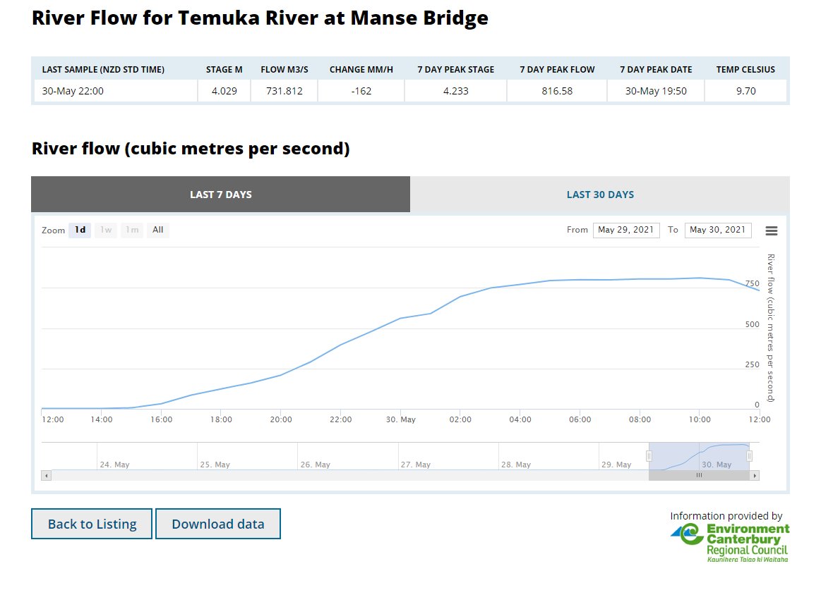
It appears this pretty looking storm is doing some serious damage. Stay safe Ōtautahi. Image
And we have a live report from north Canterbury.
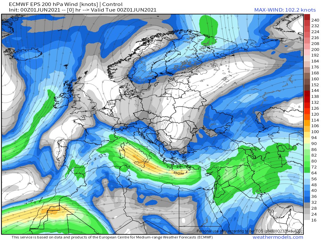
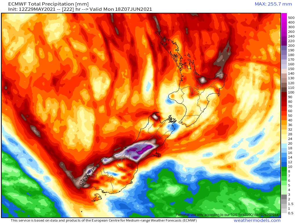
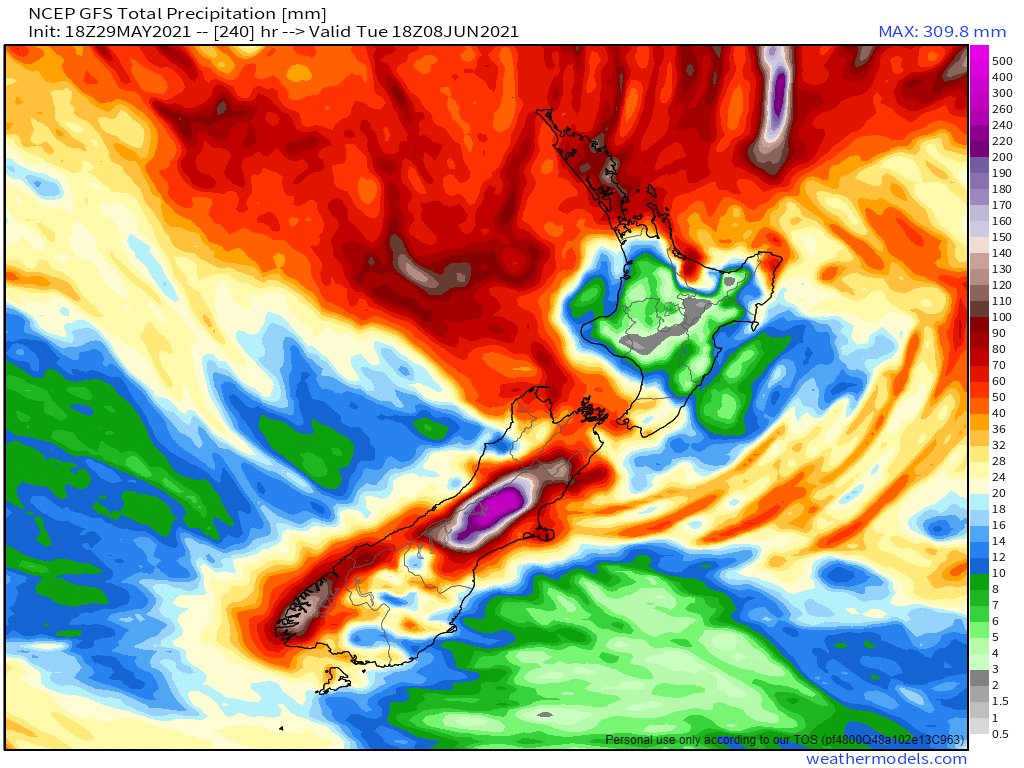
NOTE: This is not an official forecast. But it is alarming. It seems that that peculiar cloud formation is special in a number of rather alarming ways. [Image: @NOAA's GFS model forecast, latest run.]
The Euro @ECMWF model is saying pretty much the same thing. The scale is different so it doesn't look as bad. Both of these are till midday on Thursday. Image
Longer range forecasts show there's not a lot of relief in sight. A second big rain is due to arrive on Saturday. But Northland gets the worst of that. ImageImage
Live coverage from the @NZStuff crew here >> stuff.co.nz/national/weath…
Official Met Service warnings here >> metservice.com/warnings/home
And live animations of the storm causing all this here >> zoom.earth/#view=-36.3,17…
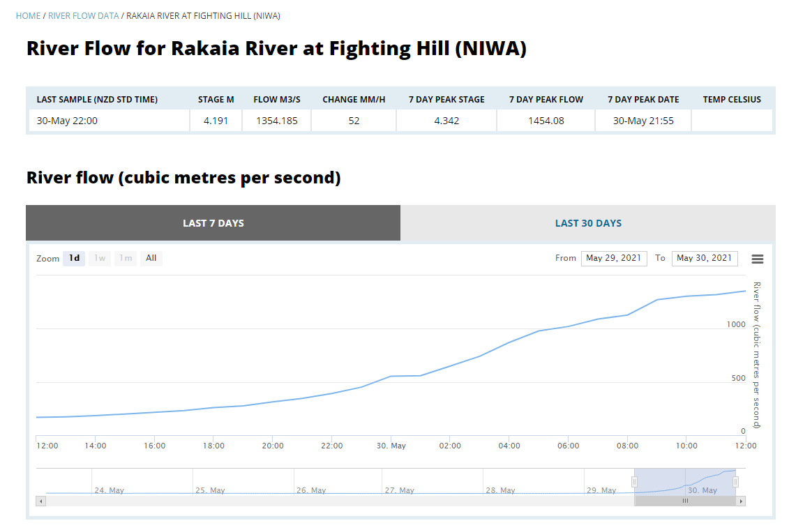
Amazing effort to rescue the guy swept away in his car in this. Stuff's live coverage of this flooding event is superb >> stuff.co.nz/national/weath… Image
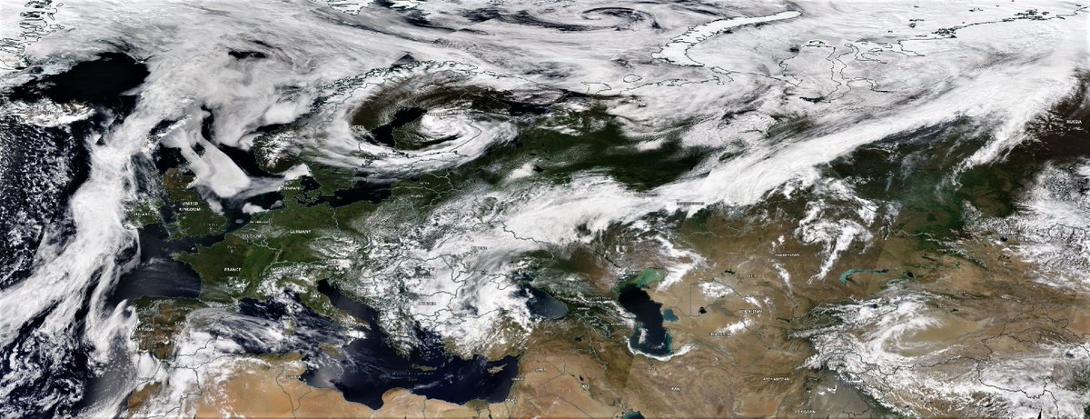
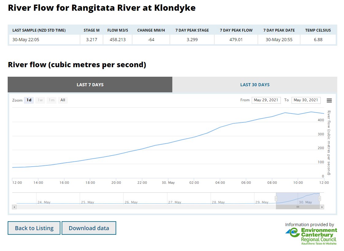
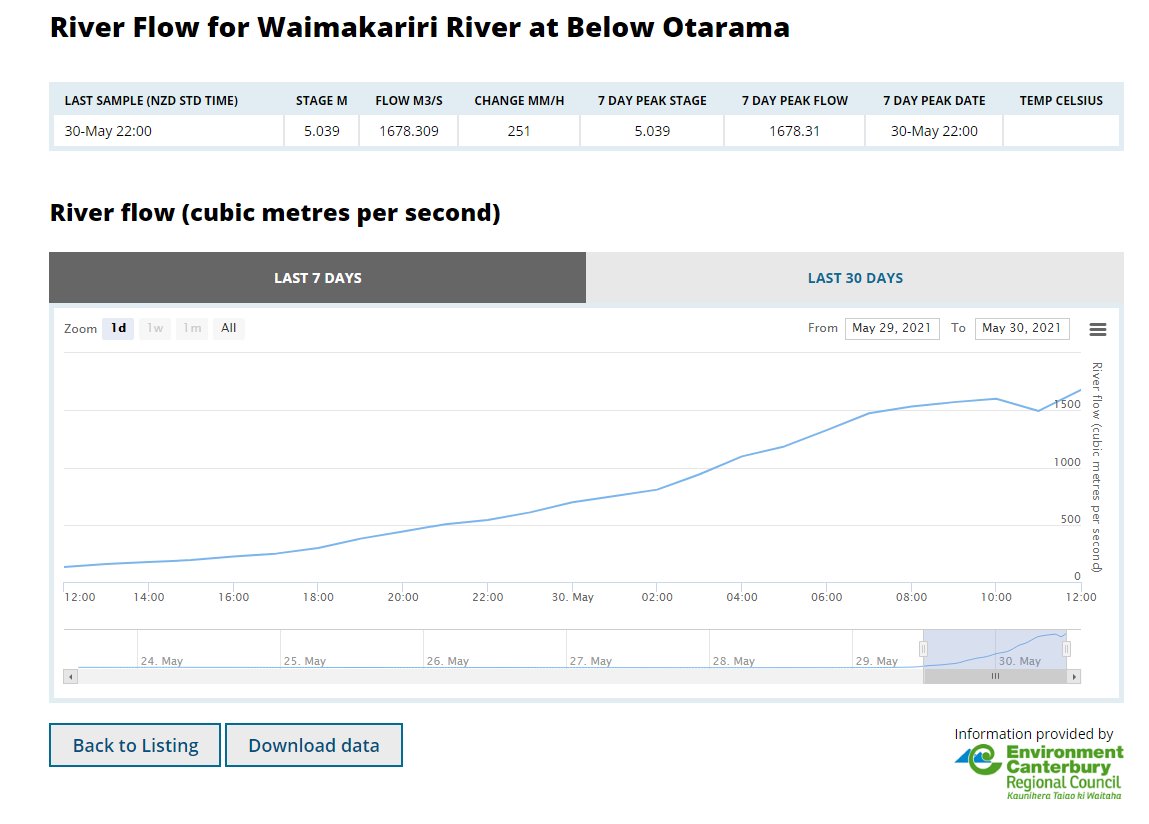
The cause of these #CanterburyFloods is remarkable.

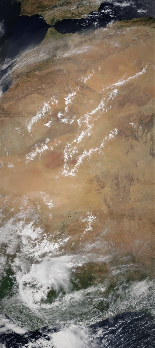
This animation (Oz's Access-G Model) starts on Thursday at midday and runs to the end of the southern drama around midday on Tuesday. The water is coming from the tropics.
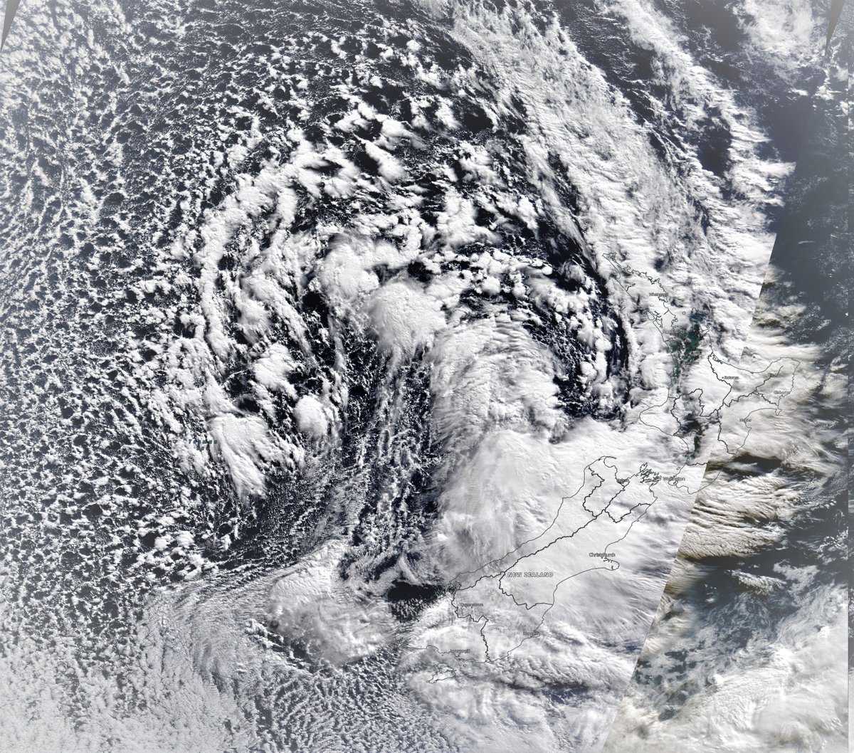
Here (Euro @ECMWF model) starts Saturday Morning and provides a closeup view through to the end. The moisture that comes in from the East circles up into Northland and then runs up the East Coast of the North Island.

Its definitely a freakish weather event. #CanterburyFloods
I have let this version (Canada's CMC Model) run to the end.Turns out something similar of tropical origins may be coming through next week. Albeit not nearly as impactful. A big wet westerly front running from Cape Reinga to Bluff. #CanterburyFloods.

• • •

Missing some Tweet in this thread? You can try to force a refresh
 

Keep Current with Alastair Thompson

Alastair Thompson Profile picture

Stay in touch and get notified when new unrolls are available from this author!

Read all threads

This Thread may be Removed Anytime!

PDF

Twitter may remove this content at anytime! Save it as PDF for later use!

Try unrolling a thread yourself!

how to unroll video
  1. Follow @ThreadReaderApp to mention us!

  2. From a Twitter thread mention us with a keyword "unroll"
@threadreaderapp unroll

Practice here first or read more on our help page!

More from @althecat

1 Jun
Well its hard to know where to begin with today's #MiddleEast and #HornOfAfrica rainfall forecasts.

The action is now further north, and west. Here we see the consequences of the first phase of what appears to be becoming a continuous #WesternSaharaPlume. Image
An bit of a battle us underway between a high pressure system over Northern Erope and the plume which is entering at the bottom left in this image of Jetstream level 250Hpa 11km high winds. Image
While the model forecasts remain optimistic that an orderly jetstream may eventually appear, so far this has not happened. And in the meantime these winds are picking up moisture in the tropics and taking it in large quantities to places where its not expected.
Read 26 tweets
30 May
A big day for #WestAfricaMonsoon observation.

A full plume event is becoming obvious in central & eastern Europe + Russia. We also have thunderstorms over the Red Sea, and a low circulation heading towards a collision with water vapour over Israel.

Today's forecasts follow.
Visually speaking this is the most extraordinary looking satellite observation of the day.

Now into its sixth day the #EastAfricaWaterPlume has been generating lots of rain over the Red Sea, both last night and today, & right now just off the coast of Jeddah. @Arab_Storms
Here we see a wider view while it is not that obvious in this view, the stream of water vapour heading up the Western Sahara coast is running fast and hot. Later I will post an initial post tracking its impact in Europe. But for now its worth looking closer at North Africa.
Read 27 tweets
30 May
Upstream flow gauges in Temuka, Rangitata, Rakaia & Waimakariri appear to be peaking or in the case of the Waimakariri close to peaking.

Meanwhile the official ECAN alerts page seems to not be freaking out, so that's all good >> ecan.govt.nz/home/flood-war….

Steady as she flows. ImageImageImageImage
"Breakouts" in the Ashburton vicinity & inland, are the major concern at present. But whatever "breakouts" are they sound a lot less alarming than floods and evacuations.

Also no alarm around the major rivers, yet. Also good.

Alerts here >> ecan.govt.nz/home/flood-war… Image
The remaining concern will be river mouth flood/tide collisions. High tide timing today is around 6.30am near Timaru, 7.50am at the Rakaia and around 8.30am in Christchuch and at the Waimakariri river mouth. ImageImageImage
Read 6 tweets
30 May
These Canterbury Floods are moving in to Otago.
Here is a wider view. This will definitely continue through a fair bit of the night. Question is now how long will it continue tomorrow? The forecast models showed the plume you see coming in from the right sort of petering out and disengaging and tracking north.
A wider view.
Read 10 tweets
25 May
With Cyclone #Yaas soaking up all the moisture east of the #MiddleEast and #HornOfAfrica it was a relatively calm day. Albeit not without another intense set of storms along the Red Sea Coast in the Jinzan mountains.

Today's rainfall forecasts follow.
The days began relatively quiet on the #WestAfricanMonsoon front thanks to Cyclone #Yaas. This image shows a strip from the Libyan Coast across the Sahara down to the Congo.
And it remained fairly quiet over the great forests of equatorial Africa today. But further West over the Ivory Coast and the West Sahara the #WestAfricaWaterPlume continued to pump water vapour across the Sahara into Europe.
Read 16 tweets
25 May
Here is the continuation of the #WestAfricaWaterPlume transformation of European weather this morning into something which is both unpredictable and not particularly nice, i.e. windy wet and cold.
The following three animations are offered to help Europeans who are curious to understand what is going on. Our weather reports tend to be geographically confined in a manner that obscures the bigger picture.
The first shows the water vapour picture over 84 hours till Friday arpund midday. The #WestAfricaWaterPlume can be seen coming in bottom left over Algeria. simultaneously another storm is coming in at speed into the British isles. Hence all the rain.
Read 6 tweets

Did Thread Reader help you today?

Support us! We are indie developers!


This site is made by just two indie developers on a laptop doing marketing, support and development! Read more about the story.

Become a Premium Member ($3/month or $30/year) and get exclusive features!

Become Premium

Too expensive? Make a small donation by buying us coffee ($5) or help with server cost ($10)

Donate via Paypal Become our Patreon

Thank you for your support!

Follow Us on Twitter!

:(