Well its hard to know where to begin with today's #MiddleEast and #HornOfAfrica rainfall forecasts.
The action is now further north, and west. Here we see the consequences of the first phase of what appears to be becoming a continuous #WesternSaharaPlume.
The action is now further north, and west. Here we see the consequences of the first phase of what appears to be becoming a continuous #WesternSaharaPlume.
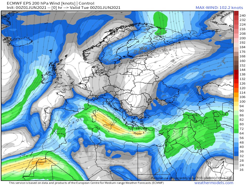
An bit of a battle us underway between a high pressure system over Northern Erope and the plume which is entering at the bottom left in this image of Jetstream level 250Hpa 11km high winds.
While the model forecasts remain optimistic that an orderly jetstream may eventually appear, so far this has not happened. And in the meantime these winds are picking up moisture in the tropics and taking it in large quantities to places where its not expected.
Same animation time scale but this time of precipitable water. This is showing little sign of of becoming less unruly within the forecast time frame. And as water has significantly more mass/inertia than air, this could explain differences between forecast and observed weather.
One thing is going according to the script however. Today is the first day of the Indian subcontinent monsoon season and the forecasts show significant rainfall across all of India over the next 12 days.
The Atlantic Hurricane season officially begins today too and we have our first long range model prognostication. A storm in one of the favoured spots for formation, off the coast of Nicaragua, heading north.
At this range though this is hugely speculative.
At this range though this is hugely speculative.

Back to the #NorthAfrica #ME & #HOA rainfall forecasts.
Here's what the picture looked like last night.
In the east storms once again over the Red sea and around Medina. And in the west the #WesternSaharaPlume strengthening.
Here's what the picture looked like last night.
In the east storms once again over the Red sea and around Medina. And in the west the #WesternSaharaPlume strengthening.
This morning the #WesternSaharaPlume is running hot bringing rain across Algeria, Spain & the Med. Rain is now forecast for where I am in Western France tonight and it looks like the rest of Western Europe will return to unseasonably wet conditions soon after.
Here are two more weather observations from this morning via @Meteoblue, the animations as always are from @zoom_earth


Here's a close up of the plume. The Eastern visible edge is moving at 100kph. On the western side clouds and storms are moving into France at 20-30kph.
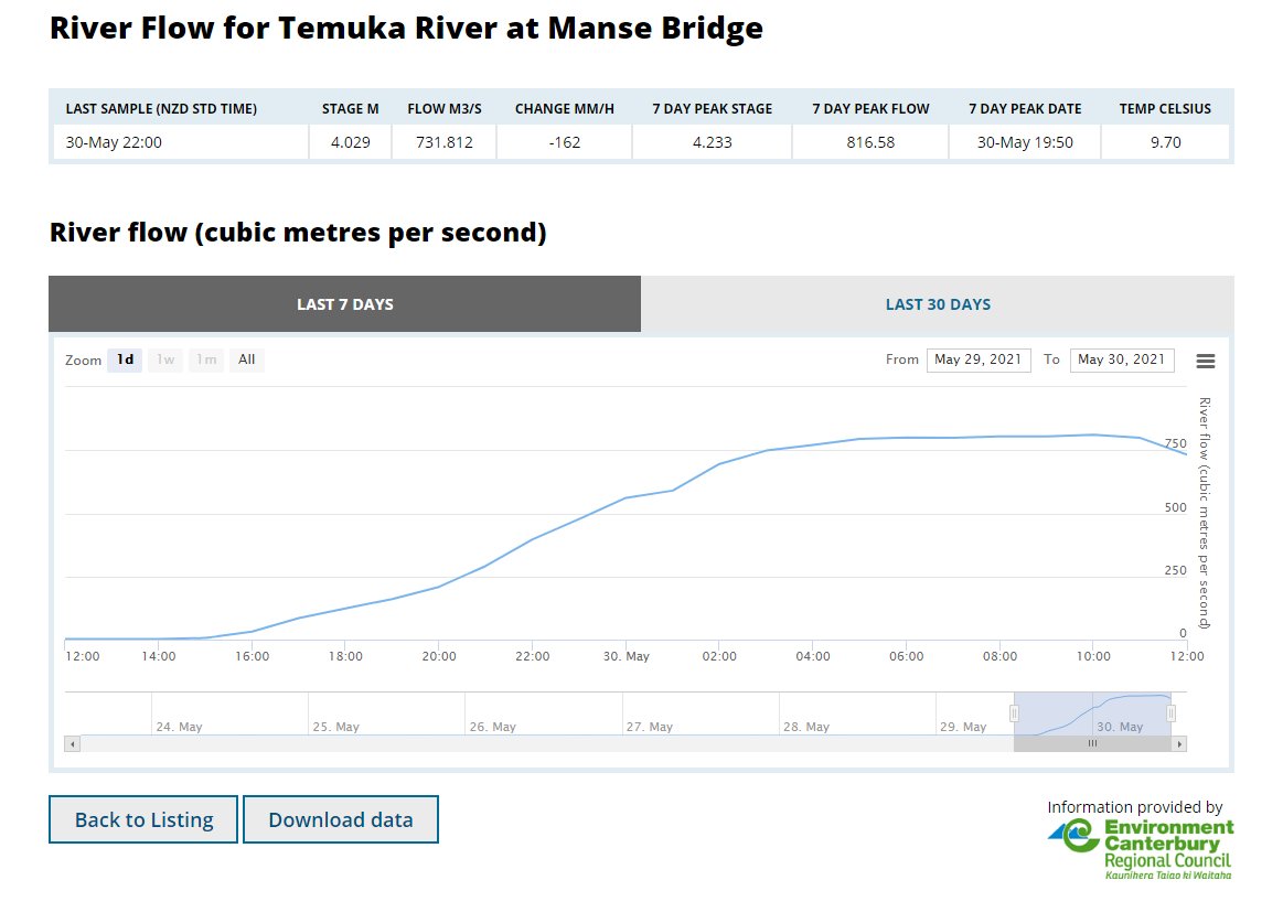
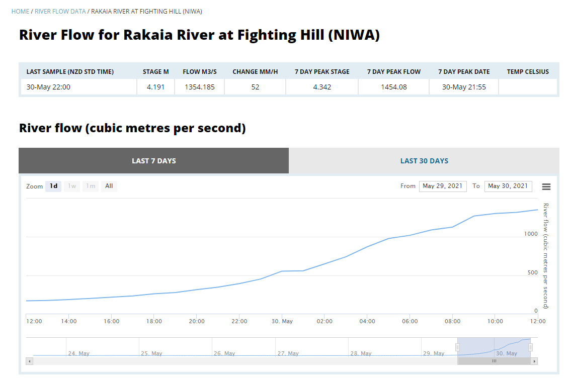
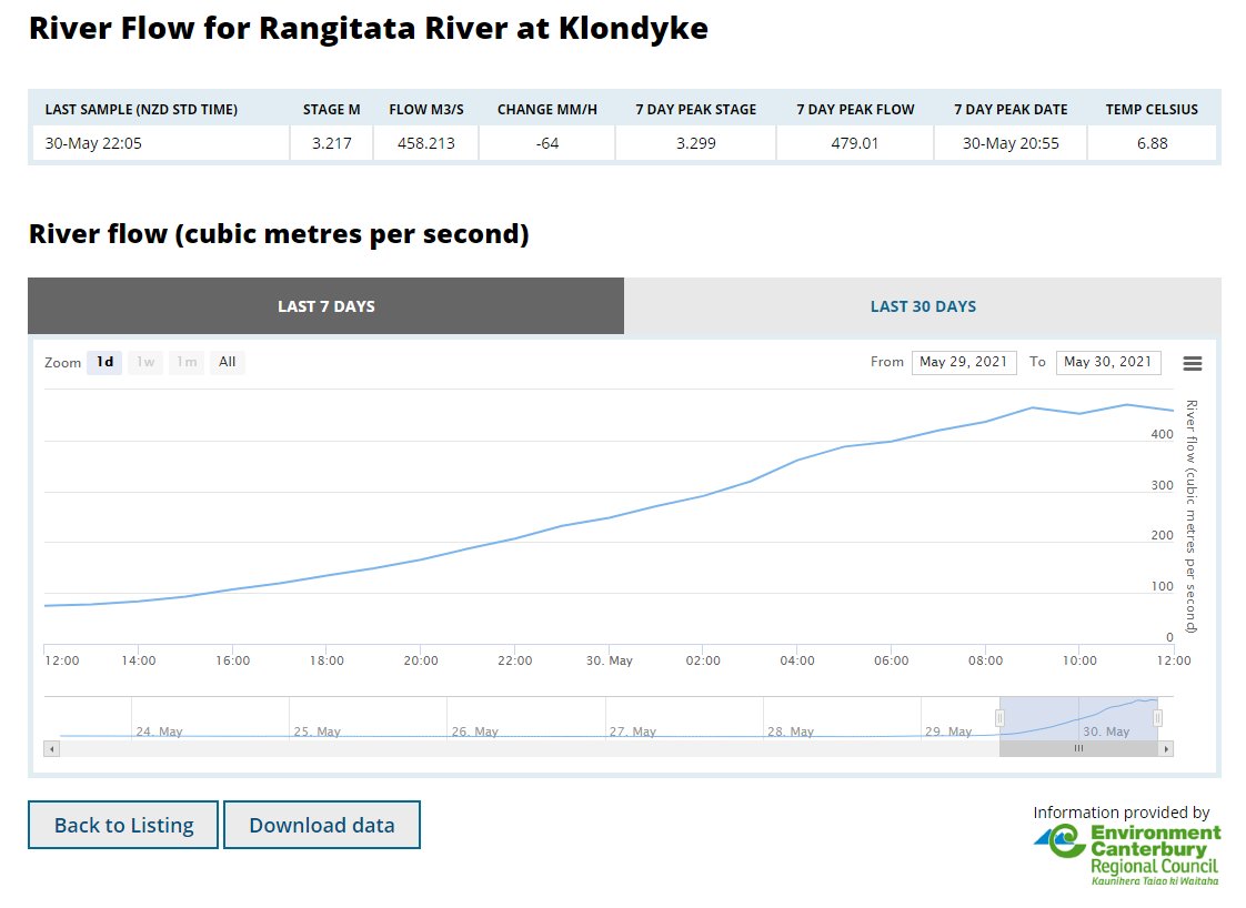
This GEFS ensemble 15 day animation models what is expected to follow. And this means a lot more rain. France's rivers are already running fairly high as are those in the east.
The result is water water everywhere. Albeit of the kind you can drink.
Again this is a 16 day forecast from the GEFS ensemble model.
Again this is a 16 day forecast from the GEFS ensemble model.
Meanwhile in Eastern Africa the #EastAfricaPlume which has resulted in rain in northern #Sudan #Egypt and #SaudiArabia has stopped but a new one may well be developing over Chad. You need to look closely as the cloud signals are fairly minor at the moment.
Wile the monsoon itself is marching westwards. Higher altitude winds - those that appear to be carrying these water streams - produced by the storm activity in Chad - are moving east, and turn north over #Sudan. Admittedly this is just a guess as to what is going on.
And finally the long range rainfall forecasts.....
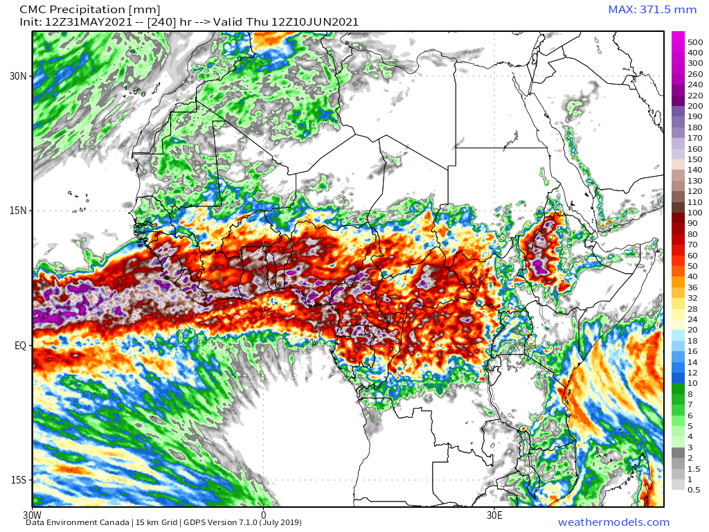
Here are today's June 1st North Africa accumulated forecasts, in descending order of #DesertRain intensity. The CMC forecast is now consistently showing 1mm of rain on average per day over a large portion of the Western Sahara.
Here are today's June 1st North Africa accumulated forecasts, in descending order of #DesertRain intensity. The CMC forecast is now consistently showing 1mm of rain on average per day over a large portion of the Western Sahara.


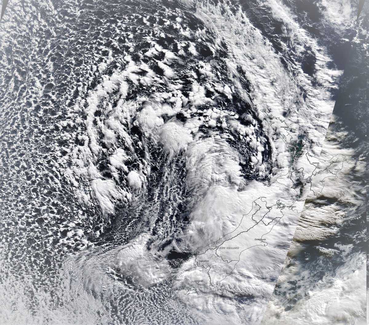
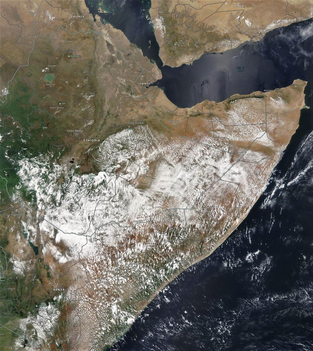
A view of Ethiopia and the Horn of Africa from this morning from @NASA's Modis satellite.
Here are today's #HoA rainfall forecasts.
1 June 10-day rain (+ 12 day KMA) forecasts for the #HornOfAfrica. The intensity of rain in the 12 day KMA forecast looks like what the Blue Nile historically delivers.
#Sudan #SouthSudan #Ethiopia #Somalia #Somaliland #GERD
1 June 10-day rain (+ 12 day KMA) forecasts for the #HornOfAfrica. The intensity of rain in the 12 day KMA forecast looks like what the Blue Nile historically delivers.
#Sudan #SouthSudan #Ethiopia #Somalia #Somaliland #GERD


And 3-Day rain forecasts to midnight Friday.
#Sudan #SouthSudan #Ethiopia #Somalia #Somaliland #GERD
#Sudan #SouthSudan #Ethiopia #Somalia #Somaliland #GERD


Here's an animation of last night's storms over the Red Sea, near Makkah and around Medina.
And this afternoon it appears there will be #ArabianStorms for at least one more day in this series in North East Saudi Arabia.
June 1st, 10 day accumulated rain forecasts for the #MiddleEast from the GFS, ECMWF, CMC & KMA weather models.
@Arab_Storms
#ArabianStorms
#KSA #Yemen #Oman #Jordan #UAE #Iraq #Iran #Syria #GERD #Sudan #Egypt #DesertRain
الله أعلم
@Arab_Storms
#ArabianStorms
#KSA #Yemen #Oman #Jordan #UAE #Iraq #Iran #Syria #GERD #Sudan #Egypt #DesertRain
الله أعلم


And 3 day forecasts from the same models to midnight Friday. From what we can see this afternoon only the CMC and KMA are within scope.
@Arab_Storms
#ArabianStorms
#KSA #Yemen #Oman #Sudan #Iran #Sudan #DesertRain #Makkah
الله أعلم
@Arab_Storms
#ArabianStorms
#KSA #Yemen #Oman #Sudan #Iran #Sudan #DesertRain #Makkah
الله أعلم


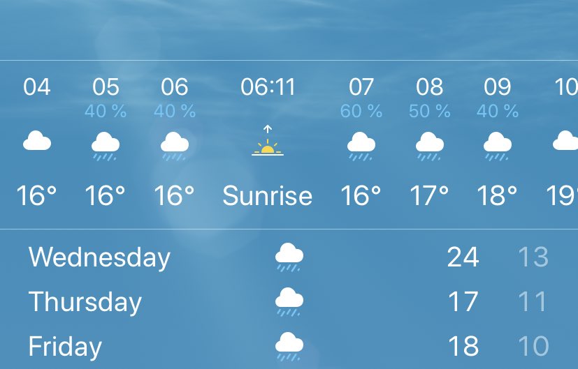
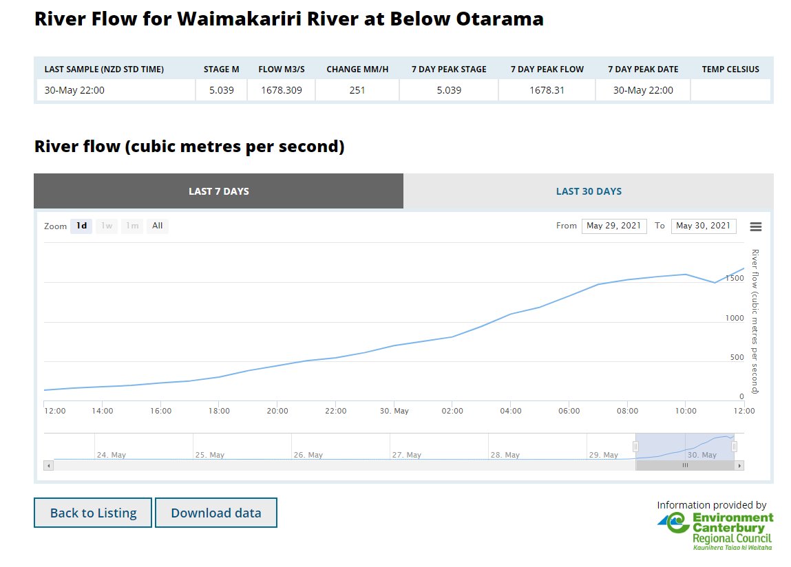
A selection of storm videos from around the world follow. The first from New Zealand, my home, where a freakish tropical moisture driven storm came close to causing significantly more catastrophic damage than what you see here.
https://twitter.com/Arab_Storms/status/1399453319278469121?s=20
Forgot to mention these are all from @Arab_Storms!
Here's an video from Spain early this morning, showing the #WesternSaharaPlume's impact in Basque Country, in the west of the Pyrenees mountains.
Here's an video from Spain early this morning, showing the #WesternSaharaPlume's impact in Basque Country, in the west of the Pyrenees mountains.
https://twitter.com/Arab_Storms/status/1399673096995360775?s=20
And from China!
Also from @Arab_Storms
Also from @Arab_Storms
https://twitter.com/Arab_Storms/status/1399641356386062336?s=20
And our final regular accumulated rainfall forecasts for today, ultra long-range forecasts from the GFS & its ensemble counterpart GEFS (16 Day) and the KMA (12 Day) models.


/ENDS
@threadreaderapp Unroll
@threadreaderapp Unroll
• • •
Missing some Tweet in this thread? You can try to
force a refresh