Here we can see Tropical Storm Bill, which looks very cyclonic now, storming north with an outrider running a parallel line to the west over the US seaboard this morning.

Cyclone Bill, soon to become extra-tropical low Bill seems determined to join the #EuropeBigWet.
What is now TS Bill was previously shown in models storming across to Ireland and removing the Leviathan Storm from the picture over the weekend. But that didn't happen and the Leviathan storm over the Black Sea is now heading south.
Nothing went quite like the models had predicted.

In the interim we have had a nice break from #EuropeBigWet in Western Europe lately. But it's now due to come to an end. Here in Brittany I currently have rain forecast for the next eight days,
The three forecast animations that follow provide a bit of a map to what comes next. Though we can probably expect the reality to be different, which is far from surprising given what you are about to see.

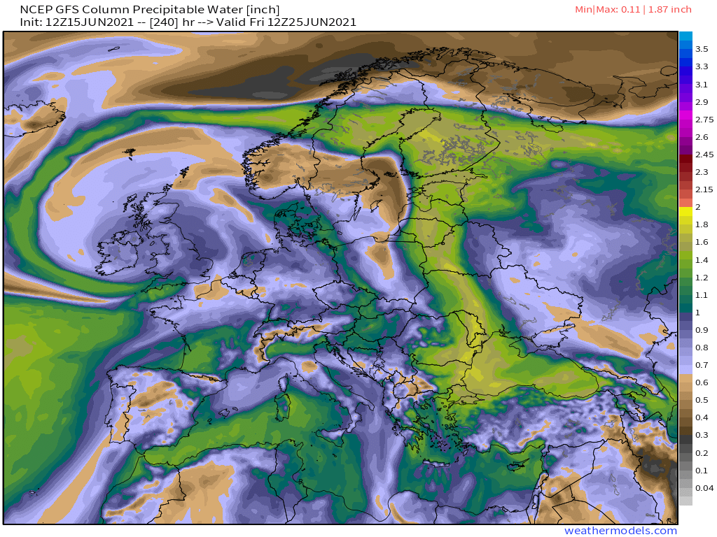
First up here's a PWAT forecast for the entire North West Hemisphere.
In the above picture yellow is atmosphere with lots of water, red is atmosphere with tropical levels of water which comes from the West African Monsoon. It is currently being recycled in massive quantities after passing through the U.S. which is experiencing endless storms.
The second animation above, also 10 days long shows rainfall accumulating over that period across the hemisphere. The GFS model used here, is not bullish about #desertrain but other models particularly the CMC also shows significant rainfall in the Sahara.
And finally here we see the mid-altitude winds over this 10 day period. What passes at the moment for a jet-stream. But unlike a normal polar jetstream - which keeps cold air trapped in the arctic and mositure out this is, as you can see transporting water all over the place.
Ok so that's the big picture. But back to Cyclone Bill because he is not finished yet. Here is what is currently expected to happen to Bill. He gets to Newfoundland, gets swallowed by a low and then pops out again.
And here you see the next chapter in that story. Bill pops back out as an ordinary low. (No longer cyclone Bill, but definitely a related entity). And then Bill 2.0 heads to the UK and stops dead.
Ok then, #EuropeBigWet, what happens next. Short answer - we no longer a clue beyond five days.

Bill not behaving as expected has resulted in 3 model solutions over 12 hours at Day 10 - all wet - which you can see below. The first solution is the newest with Bill over the UK.
Over 10 days all three solutions deliver a markedly different rainfall pattern than previously advised.
So I think we can call this #EuropeBigWet phase 3.

Of course, as we can now see, one small variable, Bill, the storm that could, then couldn't, then did can make things turn out in a completely different configuration.

• • •

Missing some Tweet in this thread? You can try to force a refresh
 

Keep Current with Alastair Thompson

Alastair Thompson Profile picture

Stay in touch and get notified when new unrolls are available from this author!

Read all threads

This Thread may be Removed Anytime!

PDF

Twitter may remove this content at anytime! Save it as PDF for later use!

Try unrolling a thread yourself!

how to unroll video
  1. Follow @ThreadReaderApp to mention us!

  2. From a Twitter thread mention us with a keyword "unroll"
@threadreaderapp unroll

Practice here first or read more on our help page!

More from @althecat

17 Jun
Unusual June rains continue in Saudi Arabia today, and for the first time since April rain fell throughout the night.

Today's #NorthAfrica, #HornOfAfrica and #MiddleEast rainfall forecasts follow. [SubThread - Mecca rains.] Image
Satellite Images arranged from East to West, the direction of tropical moisture movement and Monsoon Winds. ImageImageImageImage
North African 10-Day rainfall forecasts as of June 17th. Rains are extending north of the 15th parallel in all forecasts now. ImageImageImageImage
Read 14 tweets
17 Jun
As forecast a low has formed north east of Newfoundland and is now heading east towards the UK, where recent forecasts have indicated it may remain for several days bringing rain to Western Europe.

Todays #EuropeBigWet update.
Here in Brittany underneath the cloud mass running up Europe's Western flank it has now been raining since 4pm yesterday. A break is forecast this afternoon before it resumes in the evening.

In the image here you see the cause, clouds travelling north over the Western Sahara. Image
Here you see a close up of the source of the storms heading northwards up Europe's West Coast.
Read 7 tweets
16 Jun
A conversation with Dr Common Sense. I think this will go down very well with the people of the world, less so with the foreign policy wonks (e.g. Bolton, Haas) or the activists (e.g. Kasparov or progressives).

Thread.... Image
What has come clear to me after the last 15 odd minutes here is that Biden is trying to actually resetting the global foreign policy order itself.

The chorus will not get this in all likelihood, but this is a lot bigger than it looks. Image
The best way to explain this is with two examples.

Talking about cold wars. Biden said Putin doesn't want a new cold war. As if there isn't one.

Asked about election interference he said the U.S. does not interfere in other countries elections. As if it doesn't, hasn't. Image
Read 6 tweets
16 Jun
This time its personal!

The image below shows a large storm headed directly towards me here in Brittany, France which will arrive shortly. And it’s part of a bigger picture. #EuropeBigWet update.

NOTE: Today the Euro @ECMWF model is unavailable due to a data feed issue.
And appropriately given my two and half months monitoring this phenomena the storm that is approaching has also come 6000kms due north across the Western Sahara. I.E. its a #WestAfricaWaterPlume.
The wind is now coming up. The cows are sitting down and it’s eerily quiet. Earlier there was rumbling sounds of thunder in the distance.
Read 7 tweets
16 Jun
It's all set for another big day over the #HornofAfrica today. This big picture view contains some measurements of the monsoon wind plumes which are from Myanmar and India to the Horn.

Today's rainfall forecasts for #NorthAfrica the Horn and the #MiddleEast follow:
And while its still early, 2.30pm local time, we already have #ArbaianStorms lighting up in Saudi Arabia.
Here's a view of the storms after sunset last night from 7pm to 10pm. At present the storms over Ethiopia appear to die down by midnight. But those further West continue through the night.
Read 16 tweets
15 Jun
There was a second day of big rains over the horn today. In this image on the right hand side you can see the incoming water baring winds from across the Arabian Sea from the Indian Monsoon.

Today's #HornOfAfrica #NorthAfrica & #MiddleEast forecasts follow:
Here's a wider angle view. The water bearing mid-altitude jets provide much of the moisture that fuels the West African Monsoon, and its East African extension.
Three 10-day (+ one 12-day) accumulated rainfall forecasts for North Africa for June 15th from the GFS, CMC and KMA weather models.
Read 18 tweets

Did Thread Reader help you today?

Support us! We are indie developers!


This site is made by just two indie developers on a laptop doing marketing, support and development! Read more about the story.

Become a Premium Member ($3/month or $30/year) and get exclusive features!

Become Premium

Too expensive? Make a small donation by buying us coffee ($5) or help with server cost ($10)

Donate via Paypal Become our Patreon

Thank you for your support!

Follow Us on Twitter!

:(