It's all set for another big day over the #HornofAfrica today. This big picture view contains some measurements of the monsoon wind plumes which are from Myanmar and India to the Horn.

Today's rainfall forecasts for #NorthAfrica the Horn and the #MiddleEast follow:
And while its still early, 2.30pm local time, we already have #ArbaianStorms lighting up in Saudi Arabia.
Here's a view of the storms after sunset last night from 7pm to 10pm. At present the storms over Ethiopia appear to die down by midnight. But those further West continue through the night.
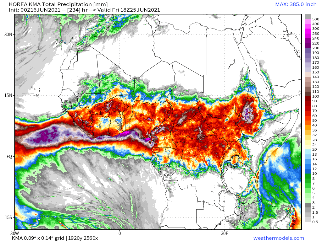
Three 10-day (+ one 12-day) accumulated rainfall forecasts for North Africa for June 16th from the GFS, CMC and KMA weather models.
As I put this forecast together something has happened in #SaudiArabia we have not seen so far this year. These #ArabianStorms are smaller and there is a lot more of them, running all the way from Yemen up to Medina and deep into the Saudi Desert.
The average rainfall in the northern parts of this area in June is zero. So far this June most days have been rain days somewhere on this coastline and further north.

Graph below shows mean Makkah rainfall in June. Some sources say zero.
[Src. weather-and-climate.com/average-monthl…]
[I will return to Saudi Arabia later.]

10-Day rainfall forecasts for June 16th of the #HornOfAfrica including, #Somalia, #Somaliland, #Djibouti, #Ethiopia and parts of #Sudan and #SouthSudan.

+ bonus 12-day forecast from KMA.

Notably the forecast models now agree.
48 hour rainfall forecasts for June 16th (today and tomorrow) for the #HornOfAfrica including #Somalia, #Somaliland, #Djibouti, #Ethiopia and parts of #Sudan and #SouthSudan.
An image of the Horn of Africa this evening, coving all the Nile's watersheds. We continue to have strong rains and will expect them to build into the evening.
We have two eyewitness videos of today's rainfall in the Kingdom of Saudi Arabia so far from @Arab_Storms.

The first shows a hail shower.
The second shows water flowing in a river bed in the Al-Shifa Valley, Wadi Al-Faraa area, south of Medina.
Here is an animation of the rainstorms in #SaudiArabia this evening.
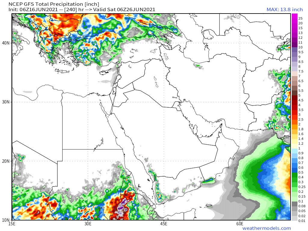
10-Day June 16th, accumulated rain forecasts for the #MiddleEast from the GFS, CMC & KMA weather models.

#ArabianStorms

#KSA #Yemen #Oman #Jordan #Sudan #Iran #Syria #GERD #Sudan #DesertRain

الله أعلم
48 Hour June 16th (today and tomorrow), accumulated rain forecasts for the #MiddleEast from the GFS, CMC & KMA weather models.

#ArabianStorms

#KSA #Yemen #Oman #Jordan #Sudan #Iran #Syria #GERD #Sudan #DesertRain

الله أعلم
And finally, June 16th 16-day (GFS) and 12-day (KMA) accumulated rainfall forecasts for the Middle East.
/ENDS

@Threadreaderapp unroll

• • •

Missing some Tweet in this thread? You can try to force a refresh
 

Keep Current with Alastair Thompson

Alastair Thompson Profile picture

Stay in touch and get notified when new unrolls are available from this author!

Read all threads

This Thread may be Removed Anytime!

PDF

Twitter may remove this content at anytime! Save it as PDF for later use!

Try unrolling a thread yourself!

how to unroll video
  1. Follow @ThreadReaderApp to mention us!

  2. From a Twitter thread mention us with a keyword "unroll"
@threadreaderapp unroll

Practice here first or read more on our help page!

More from @althecat

17 Jun
Unusual June rains continue in Saudi Arabia today, and for the first time since April rain fell throughout the night.

Today's #NorthAfrica, #HornOfAfrica and #MiddleEast rainfall forecasts follow. [SubThread - Mecca rains.] Image
Satellite Images arranged from East to West, the direction of tropical moisture movement and Monsoon Winds. ImageImageImageImage
North African 10-Day rainfall forecasts as of June 17th. Rains are extending north of the 15th parallel in all forecasts now. ImageImageImageImage
Read 14 tweets
17 Jun
As forecast a low has formed north east of Newfoundland and is now heading east towards the UK, where recent forecasts have indicated it may remain for several days bringing rain to Western Europe.

Todays #EuropeBigWet update.
Here in Brittany underneath the cloud mass running up Europe's Western flank it has now been raining since 4pm yesterday. A break is forecast this afternoon before it resumes in the evening.

In the image here you see the cause, clouds travelling north over the Western Sahara. Image
Here you see a close up of the source of the storms heading northwards up Europe's West Coast.
Read 7 tweets
16 Jun
A conversation with Dr Common Sense. I think this will go down very well with the people of the world, less so with the foreign policy wonks (e.g. Bolton, Haas) or the activists (e.g. Kasparov or progressives).

Thread....
What has come clear to me after the last 15 odd minutes here is that Biden is trying to actually resetting the global foreign policy order itself.

The chorus will not get this in all likelihood, but this is a lot bigger than it looks.
The best way to explain this is with two examples.

Talking about cold wars. Biden said Putin doesn't want a new cold war. As if there isn't one.

Asked about election interference he said the U.S. does not interfere in other countries elections. As if it doesn't, hasn't.
Read 6 tweets
16 Jun
This time its personal!

The image below shows a large storm headed directly towards me here in Brittany, France which will arrive shortly. And it’s part of a bigger picture. #EuropeBigWet update.

NOTE: Today the Euro @ECMWF model is unavailable due to a data feed issue.
And appropriately given my two and half months monitoring this phenomena the storm that is approaching has also come 6000kms due north across the Western Sahara. I.E. its a #WestAfricaWaterPlume.
The wind is now coming up. The cows are sitting down and it’s eerily quiet. Earlier there was rumbling sounds of thunder in the distance.
Read 7 tweets
15 Jun
Here we can see Tropical Storm Bill, which looks very cyclonic now, storming north with an outrider running a parallel line to the west over the US seaboard this morning.

Cyclone Bill, soon to become extra-tropical low Bill seems determined to join the #EuropeBigWet.
What is now TS Bill was previously shown in models storming across to Ireland and removing the Leviathan Storm from the picture over the weekend. But that didn't happen and the Leviathan storm over the Black Sea is now heading south.
Nothing went quite like the models had predicted.

In the interim we have had a nice break from #EuropeBigWet in Western Europe lately. But it's now due to come to an end. Here in Brittany I currently have rain forecast for the next eight days,
Read 12 tweets
15 Jun
There was a second day of big rains over the horn today. In this image on the right hand side you can see the incoming water baring winds from across the Arabian Sea from the Indian Monsoon.

Today's #HornOfAfrica #NorthAfrica & #MiddleEast forecasts follow:
Here's a wider angle view. The water bearing mid-altitude jets provide much of the moisture that fuels the West African Monsoon, and its East African extension.
Three 10-day (+ one 12-day) accumulated rainfall forecasts for North Africa for June 15th from the GFS, CMC and KMA weather models.
Read 18 tweets

Did Thread Reader help you today?

Support us! We are indie developers!


This site is made by just two indie developers on a laptop doing marketing, support and development! Read more about the story.

Become a Premium Member ($3/month or $30/year) and get exclusive features!

Become Premium

Too expensive? Make a small donation by buying us coffee ($5) or help with server cost ($10)

Donate via Paypal Become our Patreon

Thank you for your support!

Follow Us on Twitter!

:(