My first #dissertation chapter has been published! The paper focuses on #predation of #urban #wildlife by #cats with recommendations for collaborative data-driven management strategies. Main points are summarized in this #infographic, but more info and paper link in this thread! 

We spent 3 years surveying #WashingtonDC for #cats using #trailcams. Whenever we saw an image of a cat carrying prey, we noted the species and location, and added it to our predation database. 

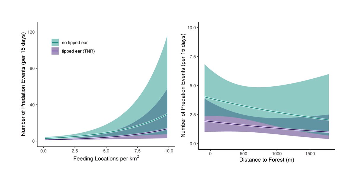
So what influences predation rates by #urban #feral cats? We found 2 driving factors: access to cat food and distance to forest edge. Why would cat food increase predation? Supplemental food allows cats to occur at greater densities, amplifying population-level predation! 

But let’s be honest – not all predation is equal. Cats killing #native species is a larger threat to #biodiversity than cats killing #rats. So we reanalyzed our data to see what drives the predation of native species. Turns out, distance to forest explains most of the variation! 

Knowledge is good and well, but how can this be applied? We propose cat management buffer areas around forests based on the probability of native predation and average cat home range. In #DC, this is what that might look like! 

Want to read the paper? Use this link, or message me with your email address if your institution doesn’t provide access: authors.elsevier.com/a/1ejTZ1R%7EeO…
Of course, I couldn’t have done this alone! This paper wouldn’t have been possible without the contributions of @Mike_Cove, @TylerFlockhart, @SMoore_Ecology, @MeLlamoRooster (and the support of the @URBANxNATURELab), as well as #twitterless Sam Decker and Bill McShea.
Want to see the best photos from this project? The project is over, but our best photos can still be found at the project’s Twitter (@DCCatCount)
Also, it was brought to my attention that the arrow depicting the relationship between distance to first and wildlife predation is pointing the wrong direction. It should be pointing down (further from forest = less wildlife predation). Sorry for the mix up!
• • •
Missing some Tweet in this thread? You can try to
force a refresh


