,
23 tweets,
9 min read
Read on Twitter
So what did I see on my way from OAK to SNA?
As always I used the trusty @flyovergeo to double-check my location. 

Here’s takeoff from Oakland heading northwest before making a turn, erm... Southwest.
I cut the timelapse short because it was soo cool to see the planes landing at SFO from a high vantage point (10,700’ according to @flightradar24). Loved seeing the large A380 (I think) cast a big shadow on the Bay. San Mateo bridge in background.

The view from atop SFO allows one to contemplate just how much the Bay has been artificially filled. Burlingame, San Mateo... I’m looking at you.


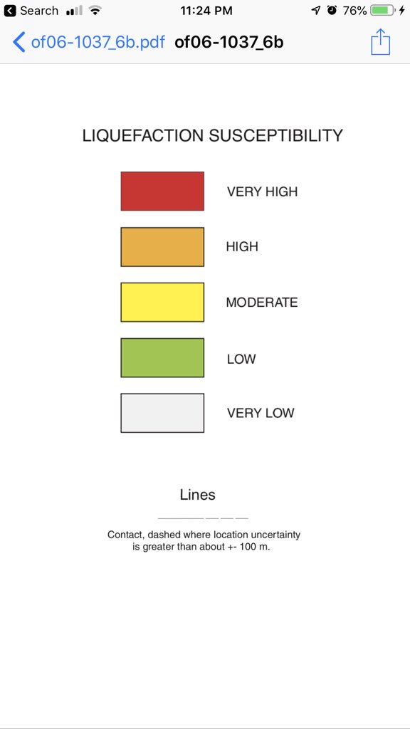
It turns out (surprise?) that building huge chunks of city and infrastructure on “loose” human-made land, which itself sits atop mud, is a terrible idea in earthquake country. Unconsolidated & saturated soils (the Bay is wet) are highly susptible to liquefaction in an earthquake.

Oops, nope... not to this part of the story yet.
That threat of ground liquefaction came into sharper focus a few seconds later as we flew over the extremely linear Crystal Springs Reservoir. Turns out putting a dam across the San Andreas Fault temporarily makes a great reservoir. Some of that water is from Hetch Hetchy!

Can anyone find Monterey Bay?

This little animation shows the sea surface temps off Monterey Bay... 57F... that water cools the air on top of it creating an inversion layer: cooled dense air layer on bottom, warmer, less-dense air on top. Long story short, the cooler air become more humid and condenses = fog!
With that in mind, Santa Cruz is at the left center of the pic and Monterey is at the right center of pic, just under the marine layer.

Here’s a fun pic for the cloud crowd. This was south of Salinas.

I’ve got to got to bed, but I’ll pick this up in the morning!

Hey I’m back for a bit! This is a cool little place called Santa Lucia Memorial Park, just south of Big Sur. It’s made up of Eocene to Miocene-aged “marine rocks”. I’be never been. Mountains in background are part of the Salinian Block of granitic rocks...

Those granitic rocks formed at the southern end of Sierra and Mojave area when subduction and volcanic arcs ruled off the coast of CA 250-60Ma. The pic strangely has east on the left and west on right. So how did rocks from So Sierra end up along the CA coast?

A mechanism of transport may become more obvious as we continue down the coast.
Next up, making our way south, was Fort Hunter Liggett. The circular drainage pattern near the dead-center of the photo caught my eye. I’m curious why it exists.

Lake San Antonio and Lake Nacimiento... oddly enough the reservoir is used to supply groundwater recharge! Water flows from dam into SA river where water infiltrates. It’s also the place where I used to go Bald Eagle watching in the mid 1980’s.

The middle of this photo is keyed into the Whiterock Bluff Shale of the Monterey FMT, making, of all things, a bluff. Shell Creek cuts across this outcrop just before it peters out and exposes younger Santa Margarita sandstone. Called shell creek for a reason :-)


I wish I had taken more geology while I was a student @CalPoly, but I was mostly focused on aeronautical engineering and track at the time. I didn’t know then that SLO butts up to a melange of ultramafic and metavolcanics.

For the record, my team’s class project for a technical writing course resulted in the resurfacing of the Cal Poly track... it was old and gave me a year of stress fractures. Also, SLO has grown.

Remember how we were wondering how the Salinian Block of granitic rock got from the southern Sierra/Mojave Desert to The Coast (like Big Sur)? Whelp, the Carrizo Plain has answers. The ridge behind Soda Lake is the Temblor Range! Created by the San Andreas Fault at its base.

I only have a few more pics to go, but I am once again getting tired and will finish tomorrow!