The German and European low country flooding of last week is astonishing and terrifying. This thread compiles youtube videos of the coverage. The death toll is still expected to rise significantly.
The previous video was @Channel4News 16th July report. Here is their 17th July report.
Here is the BBC report from Friday 16th.
And the US NBC nightly news report from the 17th.
Here is the BBC news report from July 15th.
And an @AJEnglish news report posted to youtube today.
And another @AJEnglish report posted to youtube today.
And @AJEnglish's Inside Story panel discussion on the implications from last night.
• • •
Missing some Tweet in this thread? You can try to
force a refresh
Congratulations to Ethiopia and Ethiopians everywhere on today's completion of the 2nd filling of the #GERD. It has been a great honour to follow along during this moment.
In honour of the #GERD we will change up the order of today's bulletin and get right to the most important issue, rain over the #Abbay basin, which due to its great quantity and consistency made this possible over such a short time period.
But first a brief explanation, as when it comes to the GERD not all rainfall counts. The first image here shows the path of the #BlueNile / #Abbay from Lake Tana to Khartoum where it meets the White Nile and becomes "The Nile".
Here's a view of the two storms, #FabianPH / #INFA whose interaction is forecast to produce a 3rd storm in 4 days time which was forecast yesterday to arrive in Tokyo two days after the Olympics opening.
In the latest GFS 1hourly simulation model the solution remains the same as of today. A large typhoon like low (in terms of water content) will make landfall in Japan and stay over the country for some time bringing torrential rains during #Olympics2021
This attached thread from this morn looks at Typhoon #INFA ("In-fa" TS09W) which is poised to be extraordinarily disruptive to the 2021 Olympics in Japan.
It has since come clearer what we can expect from a dangerous and unusual weather system developing over the West Pacific.
And here it is today. It still has a clearly defined circulation over the Adriatic Sea.
This shows the jet stream forecast for today which pretty perfectly matches what we are seeing here from the satellite imagery.
But while the circulation is gone the jet remains. This jet looks like it is going to move into the business of delivering moisture to the Middle East.
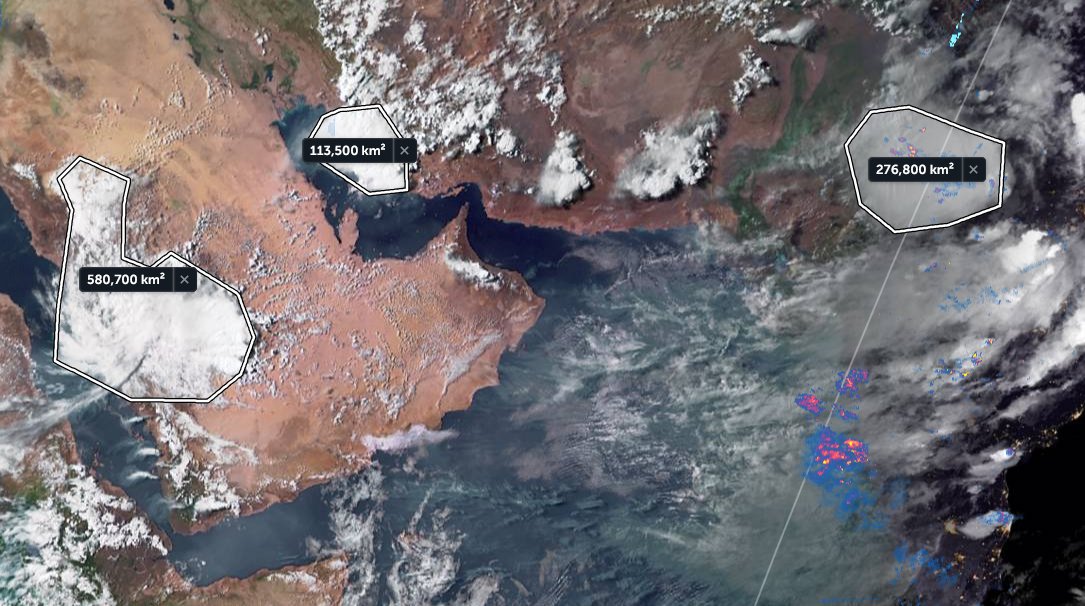
The presentation of the #ArabianMonsoonBurst has changed dramatically today with the consolidation of activity over the Arabian Peninsula into a single huge storm which is currently moving into the Red Sea over Makkah and Jeddah.
Today's rainfall forecasts follow.
The scale of the storm over Islam's holiest city is huge, larger than France. Two more huge storms loom over the greater region tonight. One on the Iranian Gulf coast and another supercell thunderstorm complex over New Delhi/Rajastan, India, the size of the United Kingdom.
The last six hours in three animations, first India which is experiencing a massive monsoon day today in the north.
[Here the initial frames show a blank SEA as their was a satellite data outage.]
This thread provides a tour of the global biosphere in pictorial form.
The animations were acquired from @zoom_earth on July 14th, and take us on a journey beginning in the North East Pacific over the course of a single day.