A Portrait of Earth's Biosphere

This thread provides a tour of the global biosphere in pictorial form.

The animations were acquired from @zoom_earth on July 14th, and take us on a journey beginning in the North East Pacific over the course of a single day.
The first image ^^ is of North West America.

Here we see the South East Pacific
North East Pacific
South West Pacific - Great Southern lands
Central Pacific
North West Pacific

See also attached thread... (this is where the most serious extreme weather situation is underway)
East Asia - China
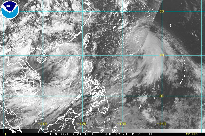
The Indo-Asia Monsoon (South East Asia & The Indian Subcontinent)
Central Asia
Southern Indian Ocean
Europe
The West African Monsoon - Central Africa
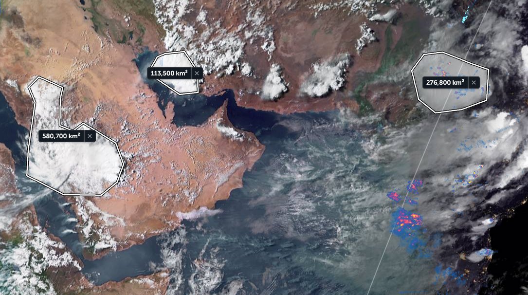
The Arabian Sea
Southern Africa
The North Atlantic
The Mid Atlantic
The Amazon Monsoon (Northern South America)
Equatorial Atlantic Ocean
South Atlantic
And that's it.

Morning around the globe on the 13th-14th July.

NOTE: Each of the animations above is to the same scale. I.E. covers the same area, and as a result provides a better idea of scale than we tend to get from Mercator projection maps.
Finally we have three big images also of July 13th-14th which cover the entire globe (excluding the poles)

The Pacific
Africa, Asia & Australasia
And finally the Americas, Atlantic, Europe and Africa
The source of this imagery is @zoom_earth, a web application that I cannot recommend more highly.

/ENDS

@Threadreaderapp unroll

• • •

Missing some Tweet in this thread? You can try to force a refresh
 

Keep Current with Alastair Thompson

Alastair Thompson Profile picture

Stay in touch and get notified when new unrolls are available from this author!

Read all threads

This Thread may be Removed Anytime!

PDF

Twitter may remove this content at anytime! Save it as PDF for later use!

Try unrolling a thread yourself!

how to unroll video
  1. Follow @ThreadReaderApp to mention us!

  2. From a Twitter thread mention us with a keyword "unroll"
@threadreaderapp unroll

Practice here first or read more on our help page!

More from @althecat

19 Jul
Congratulations to Ethiopia and Ethiopians everywhere on today's completion of the 2nd filling of the #GERD. It has been a great honour to follow along during this moment.

Today's rainfall forecasts for #NorthAfrica, #HornOfAfrica and #MiddleEast follow.
In honour of the #GERD we will change up the order of today's bulletin and get right to the most important issue, rain over the #Abbay basin, which due to its great quantity and consistency made this possible over such a short time period.
But first a brief explanation, as when it comes to the GERD not all rainfall counts. The first image here shows the path of the #BlueNile / #Abbay from Lake Tana to Khartoum where it meets the White Nile and becomes "The Nile".
Read 40 tweets
19 Jul
Today's #FabianPH #INFA, #Olympics, #Olympics2021 disruption update thread.

See yesterday's thread below.

TL/DR: There is a significant typhoon/extreme rainfall threat to Japan in the opening days of the Olympics.
Here's a view of the two storms, #FabianPH / #INFA whose interaction is forecast to produce a 3rd storm in 4 days time which was forecast yesterday to arrive in Tokyo two days after the Olympics opening.

#Olympics, #Olympics2021
In the latest GFS 1hourly simulation model the solution remains the same as of today. A large typhoon like low (in terms of water content) will make landfall in Japan and stay over the country for some time bringing torrential rains during #Olympics2021

#Fabian #FabianPH #INFA
Read 14 tweets
18 Jul
This attached thread from this morn looks at Typhoon #INFA ("In-fa" TS09W) which is poised to be extraordinarily disruptive to the 2021 Olympics in Japan.

It has since come clearer what we can expect from a dangerous and unusual weather system developing over the West Pacific. Image
This is the story of three storms rather than one, but IN-FA will play the starring role.

1. TD10W currently menacing Hong Kong
2. "IN-FA" which is technically still TS09W (fmrl. #invest98w)

& a 3rd storm which models forecast TD10W & IN-FA will bring about in 5 days time. Image
Here's the latest satellite imagery of TD10W (left) and #INFA (right) ImageImage
Read 17 tweets
18 Jul
This killer #EuropeBigWet storm is still packing a punch. Here you see it yesterday over Italy and the Balkans.
And here it is today. It still has a clearly defined circulation over the Adriatic Sea.
This shows the jet stream forecast for today which pretty perfectly matches what we are seeing here from the satellite imagery.

But while the circulation is gone the jet remains. This jet looks like it is going to move into the business of delivering moisture to the Middle East.
Read 5 tweets
18 Jul
The presentation of the #ArabianMonsoonBurst has changed dramatically today with the consolidation of activity over the Arabian Peninsula into a single huge storm which is currently moving into the Red Sea over Makkah and Jeddah.

Today's rainfall forecasts follow.
The scale of the storm over Islam's holiest city is huge, larger than France. Two more huge storms loom over the greater region tonight. One on the Iranian Gulf coast and another supercell thunderstorm complex over New Delhi/Rajastan, India, the size of the United Kingdom.
The last six hours in three animations, first India which is experiencing a massive monsoon day today in the north.

[Here the initial frames show a blank SEA as their was a satellite data outage.]
Read 30 tweets
18 Jul
There has been a sharp increase in discussion of climate change weather extremes in the context of the flood calamity in Western Europe, wildfires in the North West US, and the #ArabianMonsoonBurst

This thread looks at the big picture right now. What's next?
The image above from @Meteoblue shows most of the Northern Hemisphere & rainfall at the moment. The intense blobs of colour indicate high rainfall from thunderstorms.

What is immediately apparent looking at this is that there is an immediate issue now in the West Pacific.
What will soon be Typhoon In-Ha is forecast to make landfall in Taiwan and then stall bringing massive rainfall to the Philippines, China and Taiwan.

There is second tropical storm to the left of what will soon be In-ha which is simultaneously bringing extreme weather to HK.
Read 9 tweets

Did Thread Reader help you today?

Support us! We are indie developers!


This site is made by just two indie developers on a laptop doing marketing, support and development! Read more about the story.

Become a Premium Member ($3/month or $30/year) and get exclusive features!

Become Premium

Too expensive? Make a small donation by buying us coffee ($5) or help with server cost ($10)

Donate via Paypal Become our Patreon

Thank you for your support!

Follow Us on Twitter!

:(