The presentation of the #ArabianMonsoonBurst has changed dramatically today with the consolidation of activity over the Arabian Peninsula into a single huge storm which is currently moving into the Red Sea over Makkah and Jeddah.
Today's rainfall forecasts follow.
Today's rainfall forecasts follow.

The scale of the storm over Islam's holiest city is huge, larger than France. Two more huge storms loom over the greater region tonight. One on the Iranian Gulf coast and another supercell thunderstorm complex over New Delhi/Rajastan, India, the size of the United Kingdom.
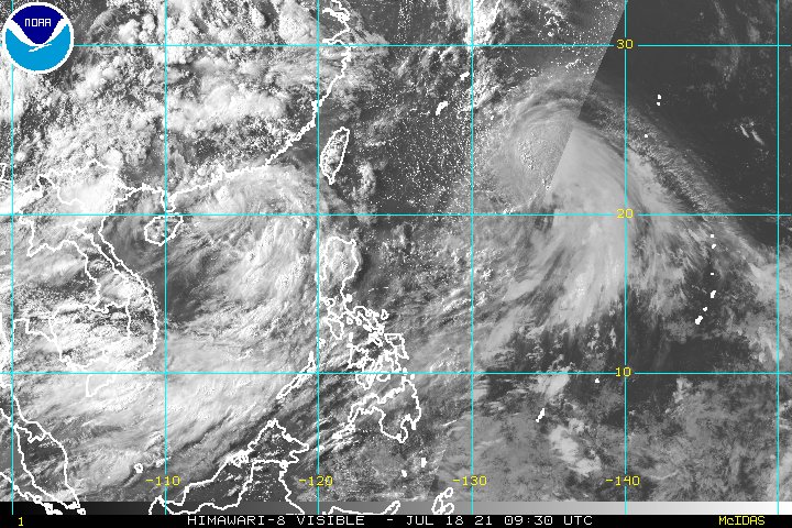
The last six hours in three animations, first India which is experiencing a massive monsoon day today in the north.
[Here the initial frames show a blank SEA as their was a satellite data outage.]
[Here the initial frames show a blank SEA as their was a satellite data outage.]
The second animation, day 6 of #ArabianMonsoonBurst, is dominated by a huge #ArabianStorm over Western Saudi Arabia, with relatively minor activity elsewhere, mostly in Yemen and Oman + a massive storm over the northern Gulf and over the Iranian Coast.
And our third covers the #HornOfAfrica, including all of the Nile watersheds, the eastern Sahel and eastern core West African Monsoon.
In summary the #ArabianMonsoonBurst extreme weather event has evolved, in line with forecast structural parameters, but not as predicted when it comes to the location of rainfall. Noticeably the storm over Saudi Arabia is currently experiencing a massive burst of convection.
None of the global models have caught this quite as it seems to be playing out so in terms of forecasts I offer two which seem to have done a fairly good job with the PWAT parameter. Here's the ECMWF version.
The ECMWF forecast is for 10 days.
Here's a shorter (and possibly more reliable) three day high resolution PWAT forecast in three hourly intervals from the CMC.
Here's a shorter (and possibly more reliable) three day high resolution PWAT forecast in three hourly intervals from the CMC.
Today's big picture takes in the greater region and the Sahara as night begins to fall over the Arabian Peninsula and the Horn of Africa.

Today's 10-Day Rainfall forecasts for North Africa from July 18th through July 29th. The #ArabianMonsoonBurst can be seen very clearly on the far right of the four accumulated rainfall forecasts.
All models now show less rain in the Middle East than in yesterday's runs.
All models now show less rain in the Middle East than in yesterday's runs.


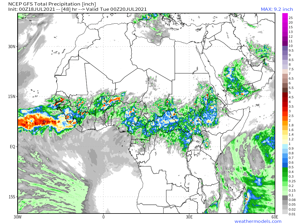
48-hour rainfall forecasts (today and tomorrow from our standard four models: the European @ECMWF, @NOAA's GFS, Canada's CMC and the Korean KMA models.
Its safe to say that none of them have got it right.
Its safe to say that none of them have got it right.


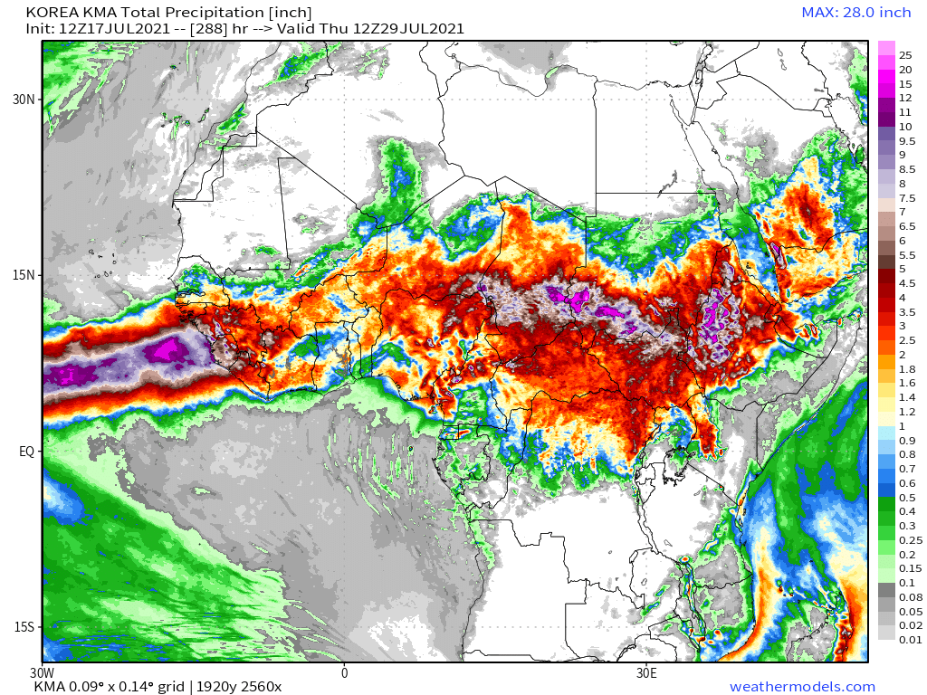
Finally for #NorthAfrica we have the long-range 16-day (GFS) and 12-day (KMA) forecasts - which (as always) remain remarkably well aligned inspite of the 4 days difference.
[NOTE: We will have a better view of forecasts of the #ArabianMonsoonBurst later in the bulletin.]
[NOTE: We will have a better view of forecasts of the #ArabianMonsoonBurst later in the bulletin.]

Here's an animation of clouds over the Northern Ethiopian, core Nile tributaries which provide 80% of nile flow. With the change in direction of the #ArabianMonsoonBurst it is a little more restrained today, but still very rainy.
Today's July 18th 16-day rainfall forecasts for #Ethiopia (+1 12-day from KMA) and the #HornOfAfrica: #Somalia, #Somaliland, east #SouthSudan, south east parts of Sudan, #Djbouti and #Eritrea.
Purple heaviest rain covers #Tigray, & #Abbay (#GERD) & #TekezeAtbara basins.
Purple heaviest rain covers #Tigray, & #Abbay (#GERD) & #TekezeAtbara basins.


48 Hour forecasts (today and tomorrow) from the same three models.


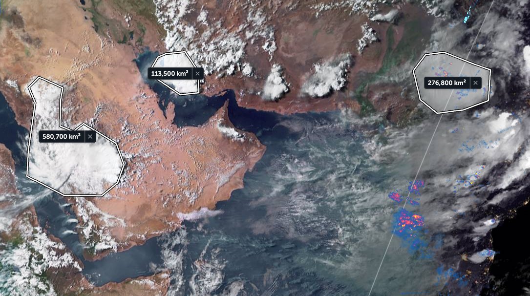
The #ArabianStorm over Saudi Arabia, covering both Mecca and Medina, and presumably bringing rain, this evening has an amazing symmetrical presentation.
#Makkah #Jeddah #Media #KSA
الله أعلم
#Makkah #Jeddah #Media #KSA
الله أعلم
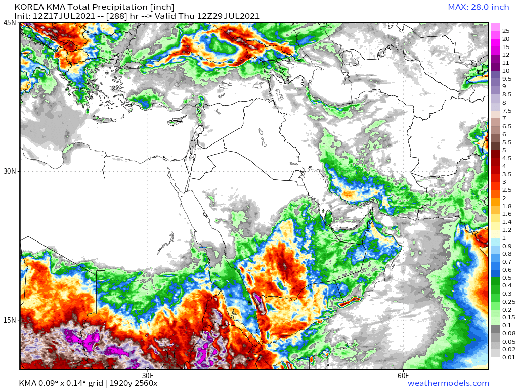
July 18th 10-Day accumulated rain forecasts for the #MiddleEast from the GFS, CMC, KMA & ACG weather models.
#ArabianStorms
#KSA #Yemen #Oman #Jordan #Sudan #Iran #Syria #GERD #Sudan #DesertRain #UAE
الله أعلم
#ArabianStorms
#KSA #Yemen #Oman #Jordan #Sudan #Iran #Syria #GERD #Sudan #DesertRain #UAE
الله أعلم


Our first @ArabStorms image today shows an extraordinary site, a massive river has formed across a major transport corridor in Saudi Arabia.
https://twitter.com/Arab_Storms/status/1416736466760314885?s=20
And here another view of this event (I assume), this time from ground level. [Courtesy of @Arab_Storms]
https://twitter.com/Arab_Storms/status/1416700465304195074?s=20
48 Hour July 18th (today and tomorrow), accumulated rain forecasts for the #MiddleEast from the GFS, CMC, KMA and ACG weather models.
#ArabianStorms
#KSA #Yemen #Oman #Jordan #Sudan #Iran #Syria #GERD #Sudan #DesertRain
الله أعلم
#ArabianStorms
#KSA #Yemen #Oman #Jordan #Sudan #Iran #Syria #GERD #Sudan #DesertRain
الله أعلم


And so it appears the models are expecting another big rain day tomorrow also. In similar areas to today.
This video of a dam spilling, spectacularly in Saudi, via @Arab_Storms, was posted by Saudi Climate Change scientist @ALMISNID.
This video of a dam spilling, spectacularly in Saudi, via @Arab_Storms, was posted by Saudi Climate Change scientist @ALMISNID.
https://twitter.com/ALMISNID/status/1416670257712963585?s=20
And finally we have today's long-range #MiddleEast July 18th rainfall forecasts.
The16-day GFS & GEFS models, the 12 day KMA and the 15 day EPS (Euro ensemble) model forecasts.
الله أعلم
The16-day GFS & GEFS models, the 12 day KMA and the 15 day EPS (Euro ensemble) model forecasts.
الله أعلم


This is the latest long-range 16-day precipitable water (PWAT) anomaly forecast for the Middle East. It suggests the event has now reached its peak. But also that significantly unusual weather may continue for some time regardless.
And here is the PWAT simulation data that the previous plot is based on. This suggests a second phase to this monsoon burst activity, albeit this time on the traditional trajectory. West south west, instead of west north west, as we have with this one.
Returning to @Arab_storms videos, here we see a man floating down a river in the back of his ute in #Oman.
https://twitter.com/Arab_Storms/status/1416666112125714435?s=20
Omani flooding looks pretty bad based on @Arab_Storms videos. Here we are back in Saudi Arabia with another huge area of flooding, this time in an urban area.
https://twitter.com/Arab_Storms/status/1416639424369205249?s=20
Also in #SaudiArabia we have this video of a spectacular cataract in full flood.
https://twitter.com/Arab_Storms/status/1416638203512115203?s=20
We now move to a big picture view. North Western Hemisphere zero hour simulation data (i.e. now).
1. Precipitable water PWAT anomaly
2. PWAT (potential rain + energy)
3. MLSP (Mean Sea Level Pressure)
4. 250Hpa (jet stream winds approx 11-15 kms high)
1. Precipitable water PWAT anomaly
2. PWAT (potential rain + energy)
3. MLSP (Mean Sea Level Pressure)
4. 250Hpa (jet stream winds approx 11-15 kms high)


And this is the last plot for today. The North Atlantic GFS Hourly model PWAT 1hr % anomaly for 120 hours, five days. And during that period it looks as if there will be a gathering of waters over the Eastern and Central Sahara.
What that will deliver will be interesting to see.
What that will deliver will be interesting to see.

/ENDS
@Threadreaderapp unroll
@Threadreaderapp unroll
• • •
Missing some Tweet in this thread? You can try to
force a refresh