This attached thread from this morn looks at Typhoon #INFA ("In-fa" TS09W) which is poised to be extraordinarily disruptive to the 2021 Olympics in Japan.
It has since come clearer what we can expect from a dangerous and unusual weather system developing over the West Pacific.
It has since come clearer what we can expect from a dangerous and unusual weather system developing over the West Pacific.
https://twitter.com/althecat/status/1416724731290603522

This is the story of three storms rather than one, but IN-FA will play the starring role.
1. TD10W currently menacing Hong Kong
2. "IN-FA" which is technically still TS09W (fmrl. #invest98w)
& a 3rd storm which models forecast TD10W & IN-FA will bring about in 5 days time.
1. TD10W currently menacing Hong Kong
2. "IN-FA" which is technically still TS09W (fmrl. #invest98w)
& a 3rd storm which models forecast TD10W & IN-FA will bring about in 5 days time.

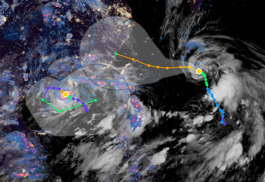
Here's the latest satellite imagery of TD10W (left) and #INFA (right)


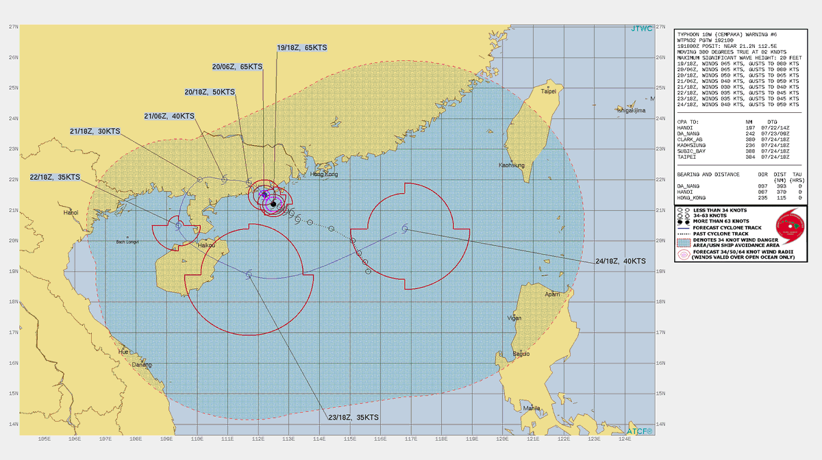
Here is In-fa's current warning graphic from the Joint Typhoon warning center.
But what this does not mention is the unusual way in which In-fa is expected to respond when it gets near to TD10W.
But what this does not mention is the unusual way in which In-fa is expected to respond when it gets near to TD10W.

This first animation from the latest GFS model shows the next 120 hours.
The thing to watch here is how the buzz saw anticlockwise spin on #INFA carves into the outflow moisture from #TD10W and flings it back out into the Pacific.
The thing to watch here is how the buzz saw anticlockwise spin on #INFA carves into the outflow moisture from #TD10W and flings it back out into the Pacific.
And that takes us to July 23rd, the day of the Olympics Opening Ceremony.
Here is another view of this same data looking at the anomaly. Because this is a super wet part of the world this time of year you can't even see #TD10W.
Here is another view of this same data looking at the anomaly. Because this is a super wet part of the world this time of year you can't even see #TD10W.
You can see #TD10W actually but barely. What is more obvious is the signature of the the depression's outflow moisture flowing back out into the Pacific.
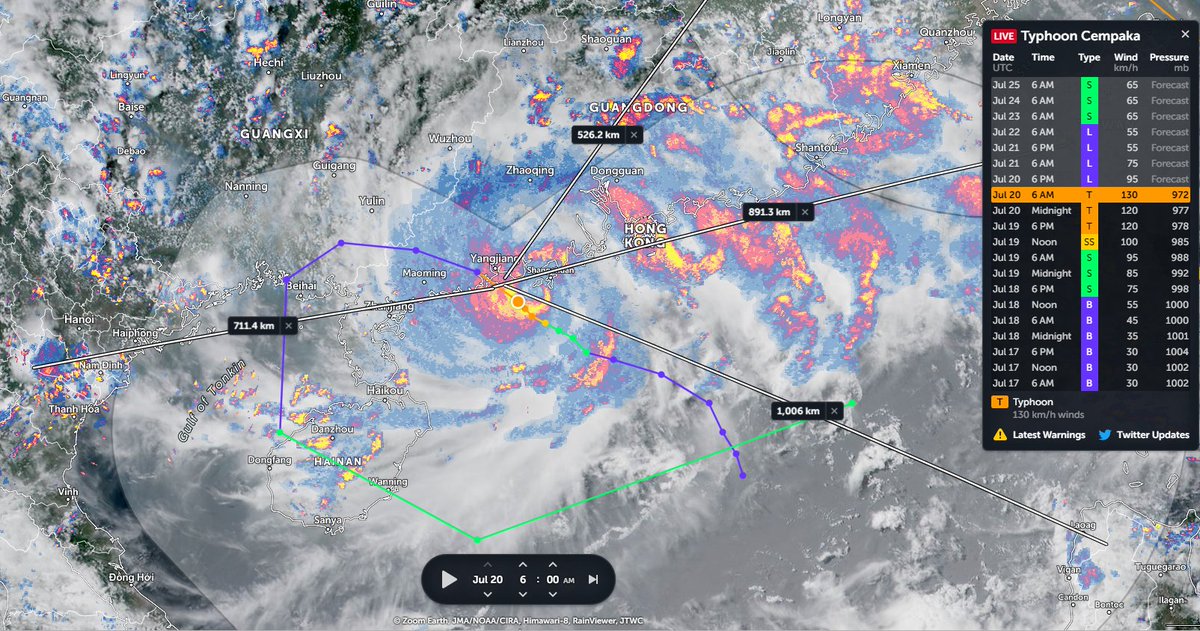
Here, courtesy of @zoom_earth we can se the two storms together with their tracks as of now, in the early hours local time. Both storms are associated with huge areas of convection due to the moisture both low pressure systems are creating.
And this moisture is the fuel which the models suggest will create the storm that might disrupt the Olympics.
This animation shows the next 72 hours. In this forecast the storm is probably a Tropical Depression but may not strengthen enough to become a cyclone.
This animation shows the next 72 hours. In this forecast the storm is probably a Tropical Depression but may not strengthen enough to become a cyclone.
This storm, if it does come about as forecast, arrives in Tokyo in the afternoon on the 25th, and parts of it remain over the Japanese Archipelego until the end of the forecast on August 3rd.
Now there are a lot of ifs and buts about this, especially about the timing and the intensity of processes that we can see in these simulations.
That said the first five days can be expected to be similar to what we see in the forecast.
That said the first five days can be expected to be similar to what we see in the forecast.
These are the accumulated GFS model rainfall forecasts for Hong Kong, Taiwan, Shanghai and China for the coming week, till Saturday. (And you can see half of Japan in there also)


As for Japan while there is a lot of uncertainty it is clear that it is under significant threat. This series of forecasts are for:
1. 5-Days (Olympics Opening - storm is beginning to form)
2. 7-Days (Outer rain bands approaching Tokyo)
1/2
1. 5-Days (Olympics Opening - storm is beginning to form)
2. 7-Days (Outer rain bands approaching Tokyo)
1/2


Accumulated rainfall forecasts for Japan at:
3. 10 days (July 28)
4. 12 Days (July 31st)
5. 14 Days (August 2nd)
6. 16 Days (Agust 4th)
2/2
3. 10 days (July 28)
4. 12 Days (July 31st)
5. 14 Days (August 2nd)
6. 16 Days (Agust 4th)
2/2


Whilst preparing to hold the Olympics, Japan is going to put in place civil defence plans to prepare for this potential deluge.
Also, this is not the worst case scenario.
It is entirely possible that this, for now hypothetical, super rain storm could become a Typhoon.
Also, this is not the worst case scenario.
It is entirely possible that this, for now hypothetical, super rain storm could become a Typhoon.
... Or this hypothetical super rain storm could miss Japan altogether and head north east into the Pacific.
To be prepared is to be fore-armed.
This is clearly the last thing Japan need's. But this is also what's so. And if anyone can manage this Japan can.
/ENDS
To be prepared is to be fore-armed.
This is clearly the last thing Japan need's. But this is also what's so. And if anyone can manage this Japan can.
/ENDS
@threadreaderapp unroll
• • •
Missing some Tweet in this thread? You can try to
force a refresh