Today's #FabianPH #INFA, #Olympics, #Olympics2021 disruption update thread.

See yesterday's thread below.

TL/DR: There is a significant typhoon/extreme rainfall threat to Japan in the opening days of the Olympics.
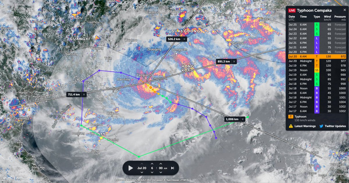
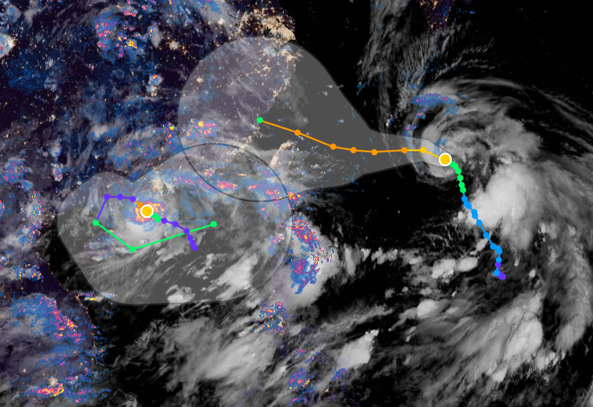
Here's a view of the two storms, #FabianPH / #INFA whose interaction is forecast to produce a 3rd storm in 4 days time which was forecast yesterday to arrive in Tokyo two days after the Olympics opening.

#Olympics, #Olympics2021
In the latest GFS 1hourly simulation model the solution remains the same as of today. A large typhoon like low (in terms of water content) will make landfall in Japan and stay over the country for some time bringing torrential rains during #Olympics2021

#Fabian #FabianPH #INFA
The animation above covers only the first five days. Here we see the full GFS Model simulation, over 16 days, from the 19th July 06hrs model run.

And this run actually looks worse than yesterdays. This solution contains is a complete mess of small low pressure systems.
And this is the associated rainfall simulation solution for Japan. The maximum rainfall number in this plot is 30.7 inches (780mm).
Here you can look at the rainfall totals a little more easily

Image one: 138 hours (July 25th).... before the storm arrives
Image two (5 days later): 258 hours (July 30th)

In this forecast nearly all the rain falls over four days, 25th to 29th.
This forecast shows this in 6 hourly increments.
The Olympic Facilities are mostly in downtown Tokyo. And we have forecasts which can more precisely target that area.
Firstly the 6-hourly rain forecast.
And the accumulated rainfall forecast.

Note this does not begin at zero. But no rain is expected in Tokyo before the storm arrives. If it arrives.
In this forecast the Olympic facilities very narrowly miss the heaviest rainfall. Here Tokyo is shown receiving between 60 and 190mm of rain over 5 days,

Worst case scenario (based on this forecast) it could receive 400mm over four days. 250% of its July monthly average.
The winds of course arrive earlier. This forecast begins next Friday (July 23 the day of the opening ceremony) and runs for six days.
In this forecast the Olympic facilities area seems to be in an inopportune spot.

This forecast shows sustained winds of between 30 and 60kmh (with gusts higher speed) for four days till the 27th then dropping back briefly before continuing to the end of the forecast on July 29.
DISCLAIMER NOTE: As this forecast is for a storm which has not yet formed, it remains fairly speculative. But something similar to this, perhaps with different timing and location is definitely on the cards.

/ENDS

@Threadreaderapp unroll

• • •

Missing some Tweet in this thread? You can try to force a refresh
 

Keep Current with Alastair Thompson

Alastair Thompson Profile picture

Stay in touch and get notified when new unrolls are available from this author!

Read all threads

This Thread may be Removed Anytime!

PDF

Twitter may remove this content at anytime! Save it as PDF for later use!

Try unrolling a thread yourself!

how to unroll video
  1. Follow @ThreadReaderApp to mention us!

  2. From a Twitter thread mention us with a keyword "unroll"
@threadreaderapp unroll

Practice here first or read more on our help page!

More from @althecat

20 Jul
Two typhoons getting closer and closer to each other. #INFA on the right is sucking the much smaller #Cempaka into its orbit. Sucking up all its outflow and chucking it out east.

The pair of typhoons current winds are fixed by JTWC at 70 and 65 knots at 06Z.
Here are the current warning graphics from the JTWC. ImageImage
#Cempaka is a midget Typhoon (1). Spinning like a top south west of Hong Kong.

Disregarding its size, #Cempaka is directing rain from Hanoi to Taiwan (2). The forecast (3 & previous tweet) shows Cempaka moving west in a loop, but this hasn't started yet. ImageImageImage
Read 31 tweets
19 Jul
Absolute scenes in South China Sea.Track forecast for Typhoon #Cempaka shows how weird set up of 2 typhoons in the same space is expected to resolve itself. Once #FabianPH / #INFA gets close it will going to drag Cempaka back out, with #Taiwan caught in between. Image
Latest JTWC satellite images of typhoons #Cempaka and #Fabian / #INFA ImageImage
And the corresponding two JTWC Warning Graphic / Track Forecasts ImageImage
Read 4 tweets
19 Jul
Congratulations to Ethiopia and Ethiopians everywhere on today's completion of the 2nd filling of the #GERD. It has been a great honour to follow along during this moment.

Today's rainfall forecasts for #NorthAfrica, #HornOfAfrica and #MiddleEast follow.
In honour of the #GERD we will change up the order of today's bulletin and get right to the most important issue, rain over the #Abbay basin, which due to its great quantity and consistency made this possible over such a short time period.
But first a brief explanation, as when it comes to the GERD not all rainfall counts. The first image here shows the path of the #BlueNile / #Abbay from Lake Tana to Khartoum where it meets the White Nile and becomes "The Nile".
Read 40 tweets
18 Jul
This attached thread from this morn looks at Typhoon #INFA ("In-fa" TS09W) which is poised to be extraordinarily disruptive to the 2021 Olympics in Japan.

It has since come clearer what we can expect from a dangerous and unusual weather system developing over the West Pacific. Image
This is the story of three storms rather than one, but IN-FA will play the starring role.

1. TD10W currently menacing Hong Kong
2. "IN-FA" which is technically still TS09W (fmrl. #invest98w)

& a 3rd storm which models forecast TD10W & IN-FA will bring about in 5 days time. Image
Here's the latest satellite imagery of TD10W (left) and #INFA (right) ImageImage
Read 17 tweets
18 Jul
This killer #EuropeBigWet storm is still packing a punch. Here you see it yesterday over Italy and the Balkans.
And here it is today. It still has a clearly defined circulation over the Adriatic Sea.
This shows the jet stream forecast for today which pretty perfectly matches what we are seeing here from the satellite imagery.

But while the circulation is gone the jet remains. This jet looks like it is going to move into the business of delivering moisture to the Middle East.
Read 5 tweets
18 Jul
The presentation of the #ArabianMonsoonBurst has changed dramatically today with the consolidation of activity over the Arabian Peninsula into a single huge storm which is currently moving into the Red Sea over Makkah and Jeddah.

Today's rainfall forecasts follow.
The scale of the storm over Islam's holiest city is huge, larger than France. Two more huge storms loom over the greater region tonight. One on the Iranian Gulf coast and another supercell thunderstorm complex over New Delhi/Rajastan, India, the size of the United Kingdom.
The last six hours in three animations, first India which is experiencing a massive monsoon day today in the north.

[Here the initial frames show a blank SEA as their was a satellite data outage.]
Read 30 tweets

Did Thread Reader help you today?

Support us! We are indie developers!


This site is made by just two indie developers on a laptop doing marketing, support and development! Read more about the story.

Become a Premium Member ($3/month or $30/year) and get exclusive features!

Become Premium

Too expensive? Make a small donation by buying us coffee ($5) or help with server cost ($10)

Donate via Paypal Become our Patreon

Thank you for your support!

Follow Us on Twitter!

:(