#Thread - #Bengaluru Airport:
What exactly happened in Bengaluru airport that led to the flooding/stagnation a few days before?
My version:

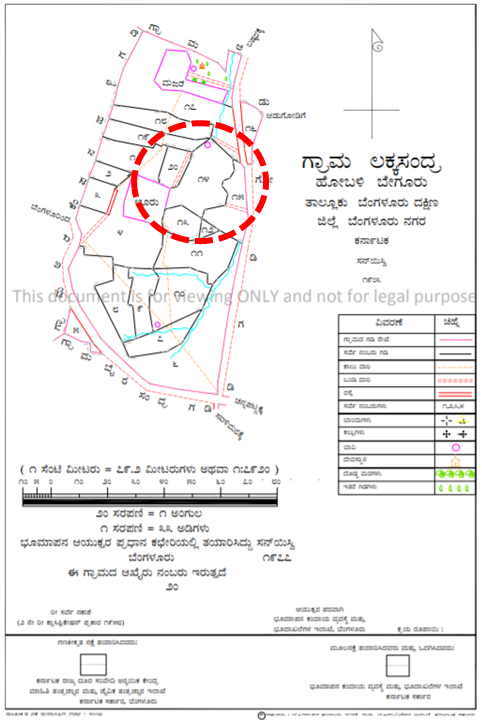
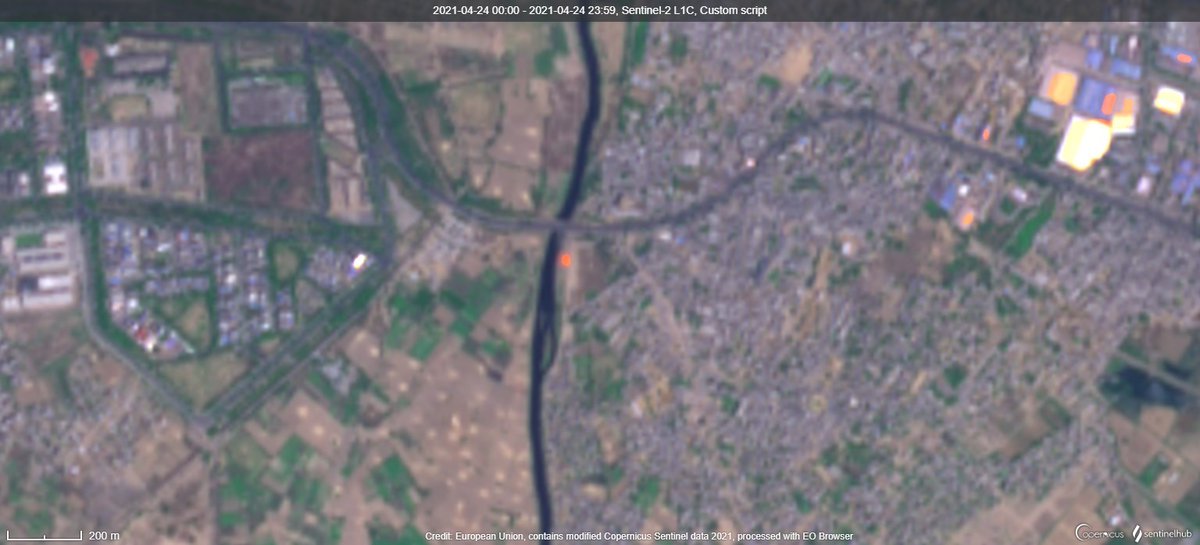
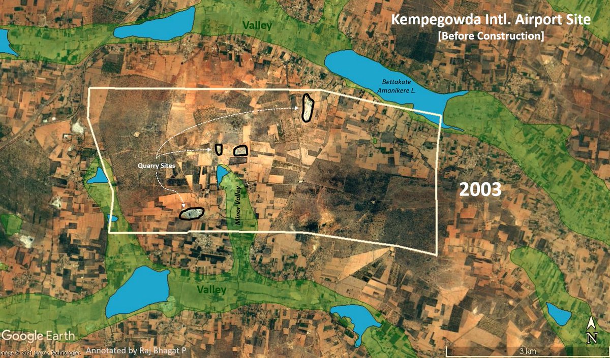
Before the airport, area (marked in white) was in a ridge between 2 valleys, had cropland, quarries, a minor valey, open scrubland
1/n
Even after the completion of phase I which was the runway in the northern side and the terminal, the minor valley was not affected significantly as it was all limited to the northern side. One quarry site also remained holding stagnant water.
2/n
This map gives you the terrain of the airport area and one can easily notice the ridge on which it was built. Water was supposed to drain into the main valleys through the minor valley.
Approximate water flow directions are marked for better understanding of terrain
3/n
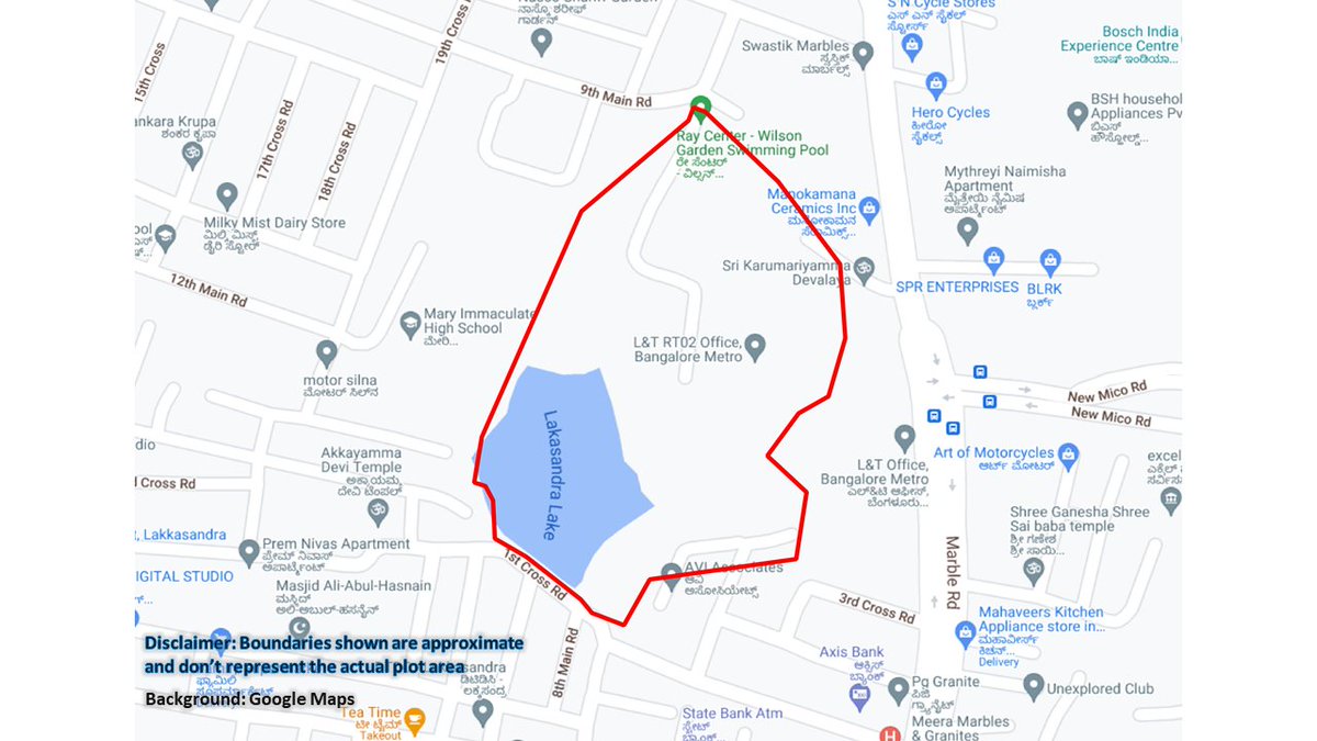
As Airport(new runway) is being expanded to the south (marked in red), minor valleys & paths for water to drain were being blocked & heavily concretized
I dont know if final design incorporates / has enuf drains, but during construction phase it didn't have provision for flow
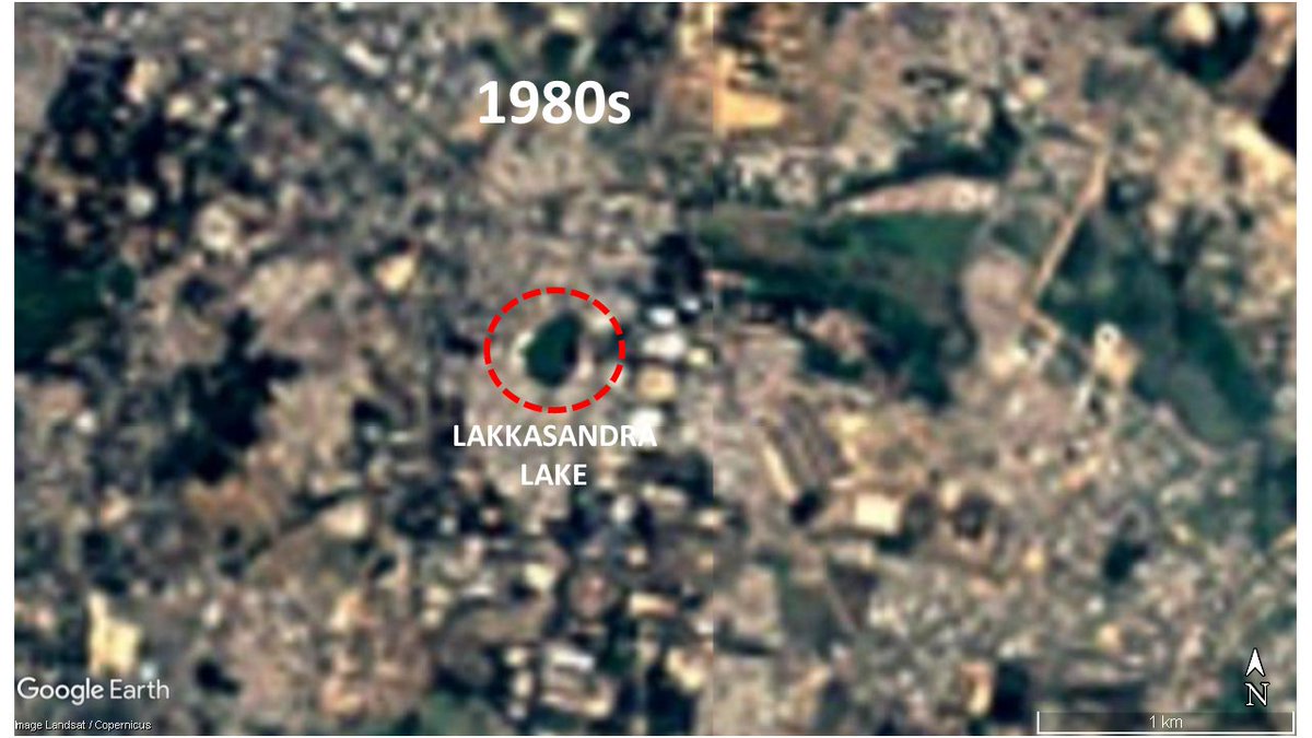
Beyond the construction phase also, there could be some issues as the old lake which existed in the middle of the airport are is being concrete lined & will not be helpful in handling flood situations in future.
In conclusion:
The rainfall in airport was heavy but it is not reason behind the flood scenes in the airport. Over concretization which reduces percolation of water, blockage of natural drains caused it

Respect the valley! It could continue if necessary paths are not provided
Sorry if this was too late. Didnt work for few days because of vaccine :(

• • •

Missing some Tweet in this thread? You can try to force a refresh
 

Keep Current with Raj Bhagat P #Mapper4Life

Raj Bhagat P #Mapper4Life Profile picture

Stay in touch and get notified when new unrolls are available from this author!

Read all threads

This Thread may be Removed Anytime!

PDF

Twitter may remove this content at anytime! Save it as PDF for later use!

Try unrolling a thread yourself!

how to unroll video
  1. Follow @ThreadReaderApp to mention us!

  2. From a Twitter thread mention us with a keyword "unroll"
@threadreaderapp unroll

Practice here first or read more on our help page!

More from @rajbhagatt

18 Aug
Viz: #Kaveri river watershed 😍

I would be posting some #maps about the river with finer details in this thread in coming days! Bookmark.. Image
FAQ
Data: SRTM
Software: QGIS
One of the biggest engineering works in Kaveri river is the Kallanai / Grand Anicut system. It was not constructed in 1 step & most of the structure that we see were erected during British era

Annotated drone image from @vikatan. The subsequent tweets deal with history of dam Image
Read 14 tweets
26 Jun
#Story of Lakkasandra lake in #Bengaluru

The thread shows the recent history and transformations it went through over time.

#Map shows the location of lake with an approximate boundary of the plot.
The waterbody in Lakkasandra might have lost its original applications many decades ago and hence revenue maps (given on the left) shows it as a government land but not specifically as a waterbody. Google Maps however shows the waterbody as it was detected in the early 2000s
But the lake seems to have water in many satellite images from 1970s, 1980s, and 1990s. It has attributes similar to any seasonal rainfed waterbody in the region
Read 15 tweets
10 May
#Thread
#Elections are supposed to be about electing representations for framing legislations

However the geography behind delimitation which doesnt consider complex socio-economic conditions promote communal polarization leading to deterioration of Democractic values

1/n
Understanding Delmitation:

The constituency delimitation is based on population. and for last delineation exercise, 2001 population was used. Average population was calculated to be 270000 people per constituency

#Map shows Population spread in Tamil Nadu
2/n
To delineate which village/town comes under which constituency, some rules are followed

To achieve the avg population, officials start with headquarters for the constituencies in district & add villages/towns within same or neighbouring taluks(subdistricts) in same district

3/n
Read 35 tweets
27 Apr
We talk about #DigitalIndia & every other meeting someone would claim that data is the new gold etc. But when it comes to critical data& good quality data, India is far far behind..

Eg: India's open data platform- data.gov.in provides the locations of hospitals
Location quality of many of these hospitals are not very accurate and 250 of them are mark outside the country!
The reason being is that they have automated geocoding using Google Maps
Why this happens: When done at a global scale, Google Maps API tries to read the address and gives the most "relevant" result. So D C Bank road (probably district cooperative bank) is marked in Washington DC
and Oxford Public School is marked in Oxford, England
Read 6 tweets
25 Apr
Thread:

I had earlier posted that I am not confident about Covid Nos & few asked explanation

Attaching satellite images where SWIR bands have picked up fire signals in crematoriums(orange colour). In most cases, this is 1st time detected or ten times intensity detected in past
Images from NOIDA, Vrindavan, Mathura, Lucknow (Clockwise from left top)

Orangish -red colour is the place of the ghats where these cremations take place
DhoriGhat, Baksar, Bhitoura, Fatehpur Ganga (These are Mild Signals)
Read 17 tweets
13 Mar
May had been asking me whether Isha encroached forest lands. IMO this is deviating from actual issue. Read full thread

Isha didNOT build on forest dept lands as such but it VIOLATED rules in other ways

Old Satellite image & map show that it was not forest but revenue land
Inorder to protect out environment, we had framed laws to secure permissions from necessary authorities. Since it was farmland and since it came under Hill Area Conservation Authority, necessary permissions were to be secured from respective offices
In their webpage, Isha says that they secured permission to construct statue on Sep - Nov 2016. But prior to securing permission itself they started constructing. Attached #Satellite images from Jan & Feb 2016 show that construction had already started before securing permission
Read 9 tweets

Did Thread Reader help you today?

Support us! We are indie developers!


This site is made by just two indie developers on a laptop doing marketing, support and development! Read more about the story.

Become a Premium Member ($3/month or $30/year) and get exclusive features!

Become Premium

Too expensive? Make a small donation by buying us coffee ($5) or help with server cost ($10)

Donate via Paypal Become our Patreon

Thank you for your support!

Follow Us on Twitter!

:(