Wim Zwijnenburg Profile picture
Dec 22 7 tweets 5 min read
📢Russia's targeting of energy infrastructure in #Ukraine is displacing millions of people, while also worsening conflict-pollution. Today we launch a new Environment & Conflict Alert, with support of @UNEP and @Cen4infoRes. A small 🧵1/x

paxforpeace.nl/what-we-do/pub…
Over the course of the last 10 months, we noted 213 reported incidents of strikes against thermal, hydro, nuclear and solar energy facilities in #Ukraine. We could verify 63 of those incidents with satellite images that observed damage to these facilities. 2/X
Throughout the country strikes against, and occupation of power plants severely impacted the lives and livelihoods of Ukrainian civilians, while also posing serious risks to their #environment from a range of pollutants or services depending on energy supplies. 3/x
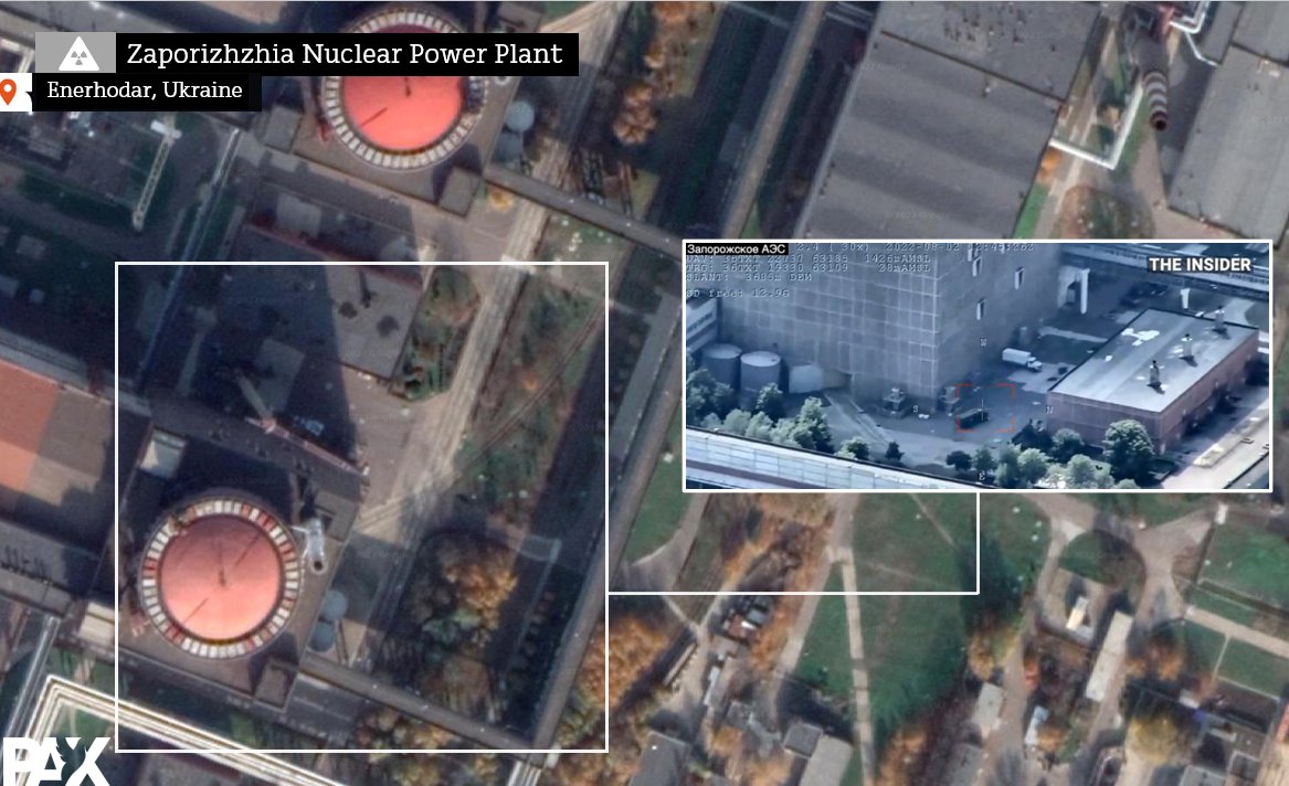
In particular the situation at #Zaporizhzhya, the largest nuclear power plant in Europe, became dire with a risk of a meltdown as energy infrastructure to cool the nuclear rods was damaged after being bombed, and it had to resort of emergency diesel generators 4/x
Other power plants are storing large amount of hazardous and toxic substances such as heavy fuel oil or PCBs, that could pose acute and long-term environmental health risks. For example, here we see a large oil spill at the Vuhleriksa TPP after intense Russian shelling 5/x
In Donbas, the extractive mining industry is depending on energy for its operations to pump out contaminated mine waters and prevent them from flooding. Absence of power supply could lead to severe regional pollution risks 6/x tearline.mil/public_page/en…
As winter has arrived, Ukrainian civilians face the cold and darkness by Russian aggression that specifically aims to impact their lives and the environment they depend on. Read our full @paxforpeace analysis and recommendations for green recovery here: paxforpeace.nl/what-we-do/pub…

• • •

Missing some Tweet in this thread? You can try to force a refresh
 

Keep Current with Wim Zwijnenburg

Wim Zwijnenburg Profile picture

Stay in touch and get notified when new unrolls are available from this author!

Read all threads

This Thread may be Removed Anytime!

PDF

Twitter may remove this content at anytime! Save it as PDF for later use!

Try unrolling a thread yourself!

how to unroll video
  1. Follow @ThreadReaderApp to mention us!

  2. From a Twitter thread mention us with a keyword "unroll"
@threadreaderapp unroll

Practice here first or read more on our help page!

More from @wammezz

Aug 16
The cumulative effects of #ClimateEmergency in #Iraq are clearly visible through open-source earth observation tools. A short thread on how drought creates a mix of smoke from burning marshes and dust storms moving over the country 1/ Image
As we shared earlier this week, the lack of water coming into the Tigris and Euphrates rivers that lead to the south is resulting in the drying of Iraq's Marshes, home to the Marsh Arabs and with a unique ecosystem, threatening the lives and livelihoods of its population 2/x Image
This year also witnessed the same patern of decline in precipitation in #Iraq, as documented by humanitarian agencies such as @REACH_info. This is impating access to clear water for households and agriculture use throughout the country 3/x
reliefweb.int/report/iraq/ir… Image
Read 10 tweets
Aug 8
More Russian military equipment is being set-up at the #Zaporizhzhia Nuclear Power Plant in Enerhodar, a new drone video shows. Here's small thread with geo-locations and recent @planet high-resolution satellite imagery showing new military positions and strike impacts🧵1/x
After entering the gate through the administrative building of the NPP, as seen on the first image , we see military truck here moving near the first of the 6 nuclear reactors. 2/x google.com/maps/place/Pro…
We can also see an MT-LB, a tracked armored fighting vehicle moving into the first nuclear reactor at the power plant, and military truck also moving to the entrance of the same reactor. h/t @Rebel44CZ / @CalibreObscura 3/x
Read 9 tweets
Jul 28
A new video posted by @rudaw reveals new information on a possible weapon and firing location that killed nine Iraqi tourists in a tourist resort, north of Zakho, Iraqi Kurdistan. A small #OSINT thread with some findings 🧵1/
rudaw.net/english/kurdis…
First, one of the shots shows a wide-area view of this area where in the last years new Turkish/KRG military bases were set-up in the fight against the PKK, also featured in @SimonaFoltyn excellent piece for @NewsHour pbs.org/newshour/show/… h/t @obretix 2/ for geolocation
Then a first time image of a munition remnant, showing the fin of a mortar, identified by @CalibreObscura as a possible Turkish MKE MOD 214 81mm mortar. More images are needed to be sure. But was it there already or recently fired? That's unclear 3/x
urunler.mke.gov.tr/Urunler/81-mm-…
Read 14 tweets
Nov 18, 2021
Enter the dragon: Chinese armed #drones now confirmed on @Airbus satellite imagery flying from #Ethiopia's Harar Meda airbase and new @planet satellite imagery showed increase activity with Iranian drones at Semera. Here's our @PAXforpeace analysis 1/x

paxforpeace.nl/news/blogs/eth…
With reports of Chinese drones being involved in the #Tigray war, initial rumors of Wing Loongs II operated by the #UAE and flying from Eritrea could not confirmed to be involved in strikes in Ethiopia, as demonstrated in this @bellingcat article 2/x
bellingcat.com/news/rest-of-w…
We learned this summer that #Iran has exported armed #drones to Ethiopia, flying from Semera air base, as showed in social media images and satellite imagery, again documented by @bellingcat 3/x bellingcat.com/news/rest-of-w…
Read 10 tweets
Jul 20, 2021
A quick update on the oil spill at #Aden in the south of #Yemen. Today's satellite imagery by @planet shows the ongoing oil on the surface while the salvage operation of the sunken oil vessel is ongoing. Image
#PT And here's radar image of the port of #Aden using @sentinel_hub Sentinel-1 SAR with an Oil Slick Custom script and Planet to show the spill. Note the image shows both water surface roughness and the spill itself, so it's not all oil in yellow.. Image
The Port of Aden has seen it's share of oil spills form ships, as can be seen on historic imagery via Google Earth Image
Read 4 tweets
Jul 20, 2021
Over the last two years we worked with local partners, used satellite imagery and open-source investigation to identify the specific problems that affects public health and the environment people depend on. Here's a small thread with what we found in NE #Syria 1/x
The main focus was on the Hasakah and to a smaller extend the Raqqa governorate, due to presence of our partners and own access. More analysis on environmental issues in the SDF controlled Deir ez Zor is in the making 2/x
Communities keep flagging public health concerns over unsafe landfills, solid waste dumping and burning. We identified over 20 large solid waste dumps, the combined size of 420 football fields. Chemicals from leachate contaminates groundwater and burning worsens air pollution 3/x
Read 10 tweets

Did Thread Reader help you today?

Support us! We are indie developers!


This site is made by just two indie developers on a laptop doing marketing, support and development! Read more about the story.

Become a Premium Member ($3/month or $30/year) and get exclusive features!

Become Premium

Don't want to be a Premium member but still want to support us?

Make a small donation by buying us coffee ($5) or help with server cost ($10)

Donate via Paypal

Or Donate anonymously using crypto!

Ethereum

0xfe58350B80634f60Fa6Dc149a72b4DFbc17D341E copy

Bitcoin

3ATGMxNzCUFzxpMCHL5sWSt4DVtS8UqXpi copy

Thank you for your support!

Follow Us on Twitter!

:(