So I wasn't actually intentionally on the look out for old SNP leaflets earlier. I was after something *much* more interesting (depending on your point of view!) There's much talk about "city mobility" in Edinburgh just now, so lets look at an earlier attempt.
Behold...
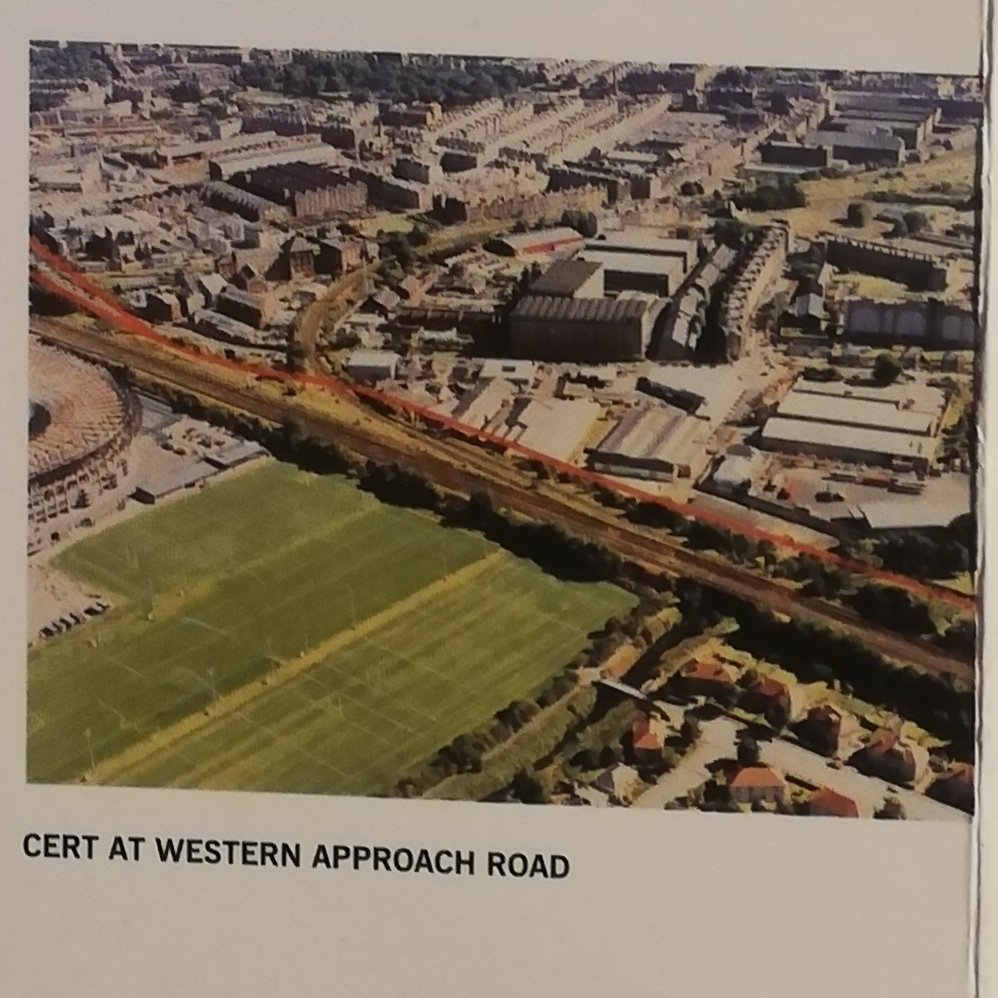
CERT!
or... City of Edinburgh Rapid Transport.
A guided busway from the Airport to the city centre via the Gyle and the direct fore runner of the current tram line.
CERT!
or... City of Edinburgh Rapid Transport.
A guided busway from the Airport to the city centre via the Gyle and the direct fore runner of the current tram line.

CERT was first mooted in about 1993 by Lothian Regional Council and the City of Edinburgh District Council during the depths of Majorism and the uninspired graphic design and woeful branding is very appropriate for the time.
CERT itself was the direct descendant of the abortive Lothian Region Metro (more on that some other time) that had been snuffed out before it got going in the late 80s due to total lack of funds available for such an adventurous scheme in a provincial backwater like Edinburgh.

Note that last paragraph. CERT was *always* planned to be capable of being turned into a tramway at some point in the future. If Edinburgh couldn't have a Metro or Trams, they at least had the forethought to try and future proof a more economical scheme to allow it.
Let's start with some numbers first. The proposal envisaged a 39 strong fleet of single decker buses that would carry 30k passengers per day, rising to 37k over the 20 years to 2010. In comparison, Edinburgh Trams started off at ~ 14k per day rising to ~20.2k by 2018
That's a lot higher than the tram scheme, but as we will see later, CERT was not just the guided busway part but also there were two other branches in West Edinburgh running on-road. CERT also had a more convenient route out of the city for some of the population centres
Lothian Region optimistically hoped that they would get the necessary parliamentary ascent by 1997 and that running services by 1999. £28 million was the estimated capital costs with a £4.4 million annual revenue cost (including the vehicles.) that fares would cover.
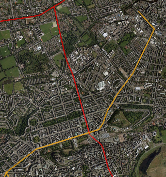
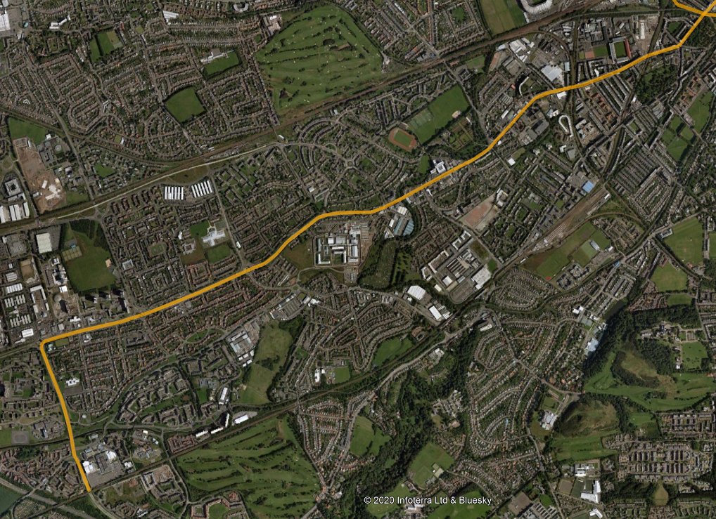
Now the fun bit: MAPS! We can see that the route was more or less the same as the tram for the western section, but at Balgreen it would cross over (or under?) the railway and run to the south of it to join up with the West Approach Road at Westfield.


Another key difference from the tramway was that it was planned to go OVER the Gogar Roundabout rather than under one side of it! Here we see one of the *very small* looking buses sailing over the then new Gogar Underpass

And here we see a schematic showing service paterns. A South Gyle "commuters' loop" was planned around the Broadway and a "branch" out to Broomhouse, Sighthill and Wester Hails was planned (although to run on the road). Notice also the never-built (at that time) Gogar station

Again, with some foresight, a corridor through Edinburgh Park had been reserved for transportation, and the section from Edinburgh Park to Balgreen had also been preserved from development (but that was for never-built roads schemes dating back to the 1940s)
This was why CERT, and the tram after it, have to dive over the railway at Stenhouse, because the unbuilt corridor swaps sides along the edge of the golf course. From the text it sounds like plan was to go under the railway using the existing bridge at Balgreen.
There were engineering challenges to cross the Water of Leith (note the tram running along the north of the railway)...


And then across the Edinburgh "South Sub" railway at Westfield. This would have involved some demolition of existing commercial properties here and I vaguely recall some controversy at the time about money for this. Note the chunk cut out of 1 building to preserve the CERT route.

And then along the old railway embankment here, across Roseburn Street on a new bridge and then connecting with the West Approach Road, itself an old railway alignment.

And here are some rather nice but vague artists impresions of what CERT might have looked like. Not that different from the tram to be honest, just missing rails and using what look like VERY small vehicles for such an intensively planned service.


CERT of course was never built, I think this was largely due to a/ the Regional Councils being dissolved in 1995 and organisational confusion that followed and b/ a lack of funding for it. I could be wrong though!
But CERT wasn't quite dead, it came back to life as a scheme called WEBS (West Edinburgh Busway Scheme) which proposed a much more modest scheme, which itself ended up in legal acrimony with a carpet bagging developer who tried to block the route for financial gain

But WEBS, or a bit of it, *did* eventually get built as Edinburgh Fastlink, a short stretch running from South Gyle Access to Stenhouse on part of the CERT route. This again was designed to allow conversion into a tramway.

Fastlink opened in 2004, before closing in 2009 to be converted into the tramway (which as we know took a further 5 years to materialise.)


Fastlink was served by the 2 and 22 bus routes which are more or less peak time commuter services for South Gyle and Edinburgh Park. The buses were initially single deck but were always rammed and had to be replaced by double deckers. They required special guidewheels
Fastlink demonstrated how good a segregated public transport corridor was, but was crippled by having to re-join the road at South Gyle Access where, despite traffic light priority, you inevitably got jammed in with all the single occupant cars.
It was flexible as it could get back on the road, but it was still a regular bus and was slow to load and unload. Even on the dedicated concrete trackway the ride was very rough and noisy. I commuted on it for most of its existence and have mixed memories.
The best thing about Fastlink though was that in 2009 when it shut, the tram project was just entering its interminable delays and legal wranglings, and for a good year or so it became Edinburgh's best and biggest cycle super highway (I was so sick of the 22 I started cycling).

Despite its long gestation and short life, CERT/WEBS/Fastlink managed to preserve the basic alignment from development for long enough to eventually lead to some proper high-capacity, environmentally friendly, urban rapid public transport in Edinburgh.
So let's hear it for CERT and it's crappy name and crappy logo.

Just recalling the time that 3 buses managed to get into a pile up on the Fastlink...

Also the time that somebody drove their car onto it by mistake, and had to crawl along the whole route at walking speed with a queue of buses behind and hundreds of commuters laughing at them, trying not to gouge big chunks out their bodywork on the guide kerbs.
For those of you that missed out on the Fastlink experience, here's a short video of the ubiquitous No. 22 bus on it
And here's some specifics about the Fastlink scheme

CERT was of course the descendant of Lothian Regional Council's hugely adventurous dead end that was the Edinburgh Metro; a city-wide proposal of rail and light rail / tram on existing and new alignments. Once again, the graphic design has that decidely late 80s municipal vibe.

The Edinburgh Metro was the result of a 2 year study from 1987-1989 on the growing problems of transport in the city, that recognised it was largely car dependent , congestion was growing, bus usage was declining as was service quality and urban rail was basically non-existant
There were a number of key elements to the proposals. The first phase, the only one that was seriously worked on, was the N-S line, to run from northern termini at Burdiehouse and GIlmerton to the city centre, then north to Trinity, then west to Davidsons Mains and Muirhouse
Here we see phase 1 in all its proposed glory. The most adventurous part of the scheme is the sub-surface section under the Southside, from Hope Park off the Meadows to St. Andrew Square. This re-hashed the route of the abandoned Southern Relief Road.

Quite how the Metro was meant to negotiate going under the Old Town, Waverley and St. Andrew Square is not really gone into in much detail! It would either have to go VERY deep, or go across the top of Waverley somehow and perhaps connect to the old Scotland Street Tunnel

the northern section would have been easy enough as it mostly followed old Railway Trackbed (which Lothian Region had only just tarmacced and converted into the North Edinburgh Path Network of walking/cycling routes).

The depot looks like it would have been on the sites of either the old Caley Railway Newhaven goods yard, or their George Street mineral yard, both of which were brownfield at the time.

Phase 2 was the E-W line, a crooked Y-shaped line running from Leith at the east end to Wester Hailes, with a branch extending to Drylaw via Roseburn. The specifics are a bit vague given it was killed off before details were worked out so we'll have to guess at the route a bit.
The northeast arm looks to have a straightforward Great Junction St. - Leith Walk - Leith St. (maybe York Pl?) alignment, then to Haymarket somehow, I've assumed along Princes St. and that it was meant to have an interchange with the deep St. Andrew Square Phase 1 station
the north arm is straightforward enough along the old railway alignment from an interface with Phase 1, then I can think of 2 possible alignments from Haymarket. Either straight up Dalry Road or around the back on the West Approach.

The west section again seems straightforward, from a terminus at Wester Hailes station up Wester Hailes Road to the A71, and then directly east. As far as Chesser there's plenty road space, from there to Gorgie things are narrower but I assume on-street running.
I've discounted it running along the old Caley mainline from the end of the West Approach Road given the sketch map shows the Phase 2 line interfacing with a station on the South Sub at Gorgie and not going anywhere near Slateford.

So Phase 1 feels like light rail or metro in its northern half, then an on-street tramway to the south. For Phase 2, only the branch from Roseburn to Crewe Toll is off street. So clearly there's a LOT of on-street running planned, with all the cost and difficulty that entails
The second component was rail improvements on the existing railway network. In the west of the city, proposals are made for new stations at Maybury (eventually built aas Edinburgh Gateway), Broomhouse (assume on the old station called Saughton) and Sighthill (now Edinburgh Park)

and in the south and east, the @edsouthsub was proposed to re-open all the former stations (some with name changes), plus new stations at Meadowbank, "ASDA" (The Jewel) and Niddrie and "Cameron Toll East" (I assume alongside Peffermill playing fields)

@edsouthsub Nothing came of this scheme (or ever has), apart from the brief opening of the temporary station at Meadowbank for the 1986 Commonwealth Games flickr.com/photos/1273405…
@edsouthsub I'll finish with an optimistic "A Word from Councillor Ron Muir". Realistically this scheme was never going to get built. Was a Thatcher government ever going to pay for it? Were the geographical and technical challenges ever going to be realistically overcome?

@edsouthsub Ooh! Addendum! It seems that in 1991 they were still playing around with this, and by this time had moved the depot west a bit, and proposed that the entire route from Canonmills to Cameron Toll would be in "a new twin tunnel" flickr.com/photos/1312323…
@edsouthsub The other option mooted (but not specifically detailed) in the Metro leaflet is "extension to Midlothian", although what that means is not quantified, one assumed it could have gone from Gilmerton, along the about to be vacated mineral railway trackbed to Loanhead and Penicuik
@edsouthsub Threadreader single-page version threadreaderapp.com/thread/1221930…