, 118 tweets, 79 min read
My Authors
Read all threads
I was going to do a "Twelve Days of Christmas"-themed thread with some Edinburgh and Leith local history but seems I'm a few days behind.
The obvious starting point is The Pear Tree House, better known to most as The Peartree bar and beer garden, on West Nicolson Street
It's an early Georgian 2-storey merchant's house, built in 1756 for William Reid as his residence. Typical of the Edinburgh style from the time it has a gable end to the facade.
The beer garden area was the private gardens and coach drive in front of the house itself.
There is a date stone of 1749, but apparently this was a later addition. The building is faced with rubble but would likely have been harled. Part of the fueing conditions for "West Nicolson House" was that the front courtyard be enclosed and used only for "the planting of trees"
Around this time, as many moved north out of the Old Town and into the New Town, others moved south around the Boroughloch, which was being drained to form Hope Park (or, the Meadows to us) and were building fashionable residences around it
The house passed to the Kilkerran Baronets, and Sir Adam Fergusson (3rd Baronet) was visited and took tea with James Boswell there in the late 1760s. Fergusson sold it in 1770, and the poet Thomas Blacklock was a resident renting rooms in it.
Both Dr Johnson and Robert Burns visited and were entertained by Blacklock there, again taking tea and various other "refreshments". After Blacklock, the house changed ownership again, coming into the hands of the Usher family.
The Ushers, who gave their name to that Hall, were an Edinburgh brewing and distilling dynasty and were serious high rollers around the town. Andrew Usher (snr) was a brewer who had pioneered blending whisky, his son Andrew (jnr) made his gazillions in this business
For a period in the mid-19th c., the Ushers used the house as a Brewery.
But it was whisky where they made it big. Andrew Jnr., along with John "Green Ginger" Crabbie and William "VAT69" Sanderson founded the North British Distillery, one of the biggest and most successful vertical column grain distilleries and still going strong.
Usher had a spare £100k (about £13M in today's money) to donate to the city to build a concert hall. The internal dome is reputed to be modelled on the dome at the top of the stairs in the Pear Tree House.
The brewery outgrew the house and moved nearby to St. Leonards at the Park Brewery, the house was used as offices and for distribution.
At this time the house was known as the Usher House. In 1918, Usher's whisky business was acquired by the Distillers Company Limited (DCL) conglomerate and formed into Scottish Malt Distillers, DCL's lowland whisky operation. They took the house with it.
SMD passed the house to its subsidiary J & G Stewart, another long-established Edinburgh whisky name (responsible for "Stewarts Cream of the Barley"). They were blenders, traders and distributors and used the house for this. It became known locally as "The House of Stewart"
Stewarts moved to Leith in 1972, and the house was shut up and abandoned behind its courtyard wall. It was mooted for a potential site of the City Arts Centre, but in 1976 it was restored for use as a pub with the courtyard becoming a beer garden.
The new name was The Peartree, after the tree which once grew in the corner of the courtyard
2 Turtle Doves. We have no Turtle Dove Streets in Edinburgh, but we have a number of Dovecots and Dovecot-named streets. Point of order, never embarrass yourself by pronouncing the V or the E.
My local Dovecot is the Lochend Dovecot, in Lochend Park, the onetime dovecot for Restalrig Tower, later Restalrig House, later Lochend House.
Dovecots were a source of meat and eggs and feathers for those rich enough to own one. And very importantly, a source of guano which was a vital industrial feedstock for the production of saltpetre for gunpowder.
The dovecot dates from the mid-16th century, and was captured in the "Petworth Map" of the 1560 Seige of Leith. Notice that "Restalrig Place" as the house is called is an expansive, rambling house atop the cliff, enclosed by a defensive wall and ditch
There are theories, from the records and the archaeology, that the dovecot was used in the 1640s as a "Plague Kiln", to incinerate the clothes and possessions of the infected and perhaps to create lime as a disinfectant. This may be why the top courses were altered
By the early 19th century, the dovecot had been re-purposed as a boathouse by the Humane Society, at which point the door was probably enlarged. The boats could be used to check if the ice was thick enough to play the popular sports of skating and curling.
According to A. N. Robertson's "Old Dovecots in and around Edinburgh" (@OldEdinClub 1945), the dovecot was then used as a store by the park keepers but he calculated that it could have housed up to 1,000 birds in its prime.
@OldEdinClub The Lochend Dovecot has been restored since to keep it structurally sound, but is gated off and abandoned to the rats and pigeons of the park.
@OldEdinClub 3. French Hens. The obvious place to go here is Little France, the charmingly named area to the south of the city where one will find the new Royal Infirmary
@OldEdinClub The name is recorded from 1655 onwards and the popular convention is that it was from the French retinue surrounding Mary Queen of Scots at nearby Craigmillar Castle
@OldEdinClub However, as early as 1786, in "An Account of the Parish Of Liberton in Mid-Lothian" by the parish minister Rev. Thomas Whyte, we are cautioned about this tale, and Stuart Harris describes the evidence as "thin" and "circumstantial"
@OldEdinClub Further to this, in his 1750s lowland "Great Map", Roy records it as the site of French Mills. A more likely story may be there was a community of French cloth millers here working a mill powered by the Burdiehouse Burn
@OldEdinClub Indeed, in 1730, the "Board of Maunfacturers' Linen Committee" set up a community of weavers from St. Quentin in Picardie, northern France. This area was noted for its expertise in weaving flax and they were keen to establish these skills in Edinburgh
@OldEdinClub Picardy would later lend its name to Picardy Place, one of the frontages of tenements built around this odd triangular parcel of land. Since the central tenement was demolished in the 1960s, Picardy Place has become the accepted name for the whole triangle
@OldEdinClub Stuart Harris also doesn't give much credence to the "community of Hugenot refugees" story for the root of Picardy Place as a name. Back to Little France, it was farmland for most of the 20th century, notable mainly for its curious name.
@OldEdinClub However, Little France does have a real claim to fame, it was the terminus of the first railway ever driven into the city, the short lived Edmonston Waggonway. I'm indebted to @CyclingEdin for teaching me most of what I know about this scheme
@OldEdinClub @CyclingEdin The Waggonway ran from a series of pits in Newton Parish on the present Midlothian / East Lothian / Edinburgh boundary, on the lands of the Edmonstone Baronets
@OldEdinClub @CyclingEdin I don't know much of the Waggonway, except that in common with such propositions it was horse powered and took a circuitous path of least resistance around the gradients for minimum engineering, as straight as possible with some sever 90 degree turns.
@OldEdinClub @CyclingEdin Little France was not an ideal terminus for getting coal into the city, however (and that's what the railways were all about), as it still was at the mercy of carters and getting it up gradients by horsepower. The Waggonway probably existed for about 10 years or so.
@OldEdinClub @CyclingEdin The southern section was later incorporated into the route of the Edinburgh and Dalkeith Railway (later the "Borders" or "Waverley" route), before it was diverted to make it steam friendly under the ownership of the North British Railway.
@OldEdinClub @CyclingEdin This boundary here, down which Little France Drive now runs, was the most obvious visual remnant of the Waggonway until the Hospital and Bioquarter took over.
@OldEdinClub @CyclingEdin 4. Collie / Calling / whatever birds. I thought I had a really clever link here with the old Scots for blackbird, but it was a red (black?) herring. So let's instead turn our attention to Burdiehouse.
@OldEdinClub @CyclingEdin The name goes back in record to the 17th century, as Burdehouse, and other forms such as Burdiehouse, Bordiehouse and Burdihouse are recorded on 17th and 18th c. maps.
@OldEdinClub @CyclingEdin But what does it mean and does it have anything to do with wee burdies?
@OldEdinClub @CyclingEdin There is an intriguing and (probable) dead end theory that it is another one of those Mary Queen of Scots French connections as some early references give it as "Bordeaux". But those are a century after the first mapmakers wrote it down
@OldEdinClub @CyclingEdin The confusion may arise because of a simple misunderstanding. Burdeous was one of the main ways Bordeaux was spelled in Scots, it's not a huge leap to imagine a mapmarker removed the "h" by mistake from Burdehous.
@OldEdinClub @CyclingEdin So if that what it ain't, what am it? Well Roy gives us a clue on his 1750s Lowland map (even though he often can't be relied on to give accurate place names), calling it Bardy Burn
@OldEdinClub @CyclingEdin Bardy may be the Scots Borde, from the Anglian Brerd, for a bank or a border, which would be a perfect toponymy for a burn that has long defined a border. An alternative may be "Bord house" being a farm that supplied the laird's table, although I would like to prefer the former
@OldEdinClub @CyclingEdin But anyways, by the time the Ordnance Survey came along and formalised things, it was recorded as Burdiehouse and Burdiehouse it has remained, as has the burn that runs along the valley
@OldEdinClub @CyclingEdin For much of its existence, Burdiehouse was a sleepy little roadside village, with cottages for farm workers, a mains (principal estate farm), and later lime workings to the south east. A school and a public house completed the attractions.
@OldEdinClub @CyclingEdin But it was a notable enough location that in 1929, the section of the Penicuik Road running from Edinburgh to the village was renamed as the Burdiehouse Road. Then in the late 1930s, council housing began marching south from the Kaimes crossroads to form the Southhouse estate
@OldEdinClub @CyclingEdin By 1938, the southward progress became defined as the Buriehouse scheme and a modern school was built to serve the estates.
@OldEdinClub @CyclingEdin The vast expansion of housing sucked the epicentre of Burdiehouse to the north and the little village became Old Burdiehouse. When the council decided to run a dual carriageway through in the late 1960s, the road deviated and the old route became Old Burdiehouse Road
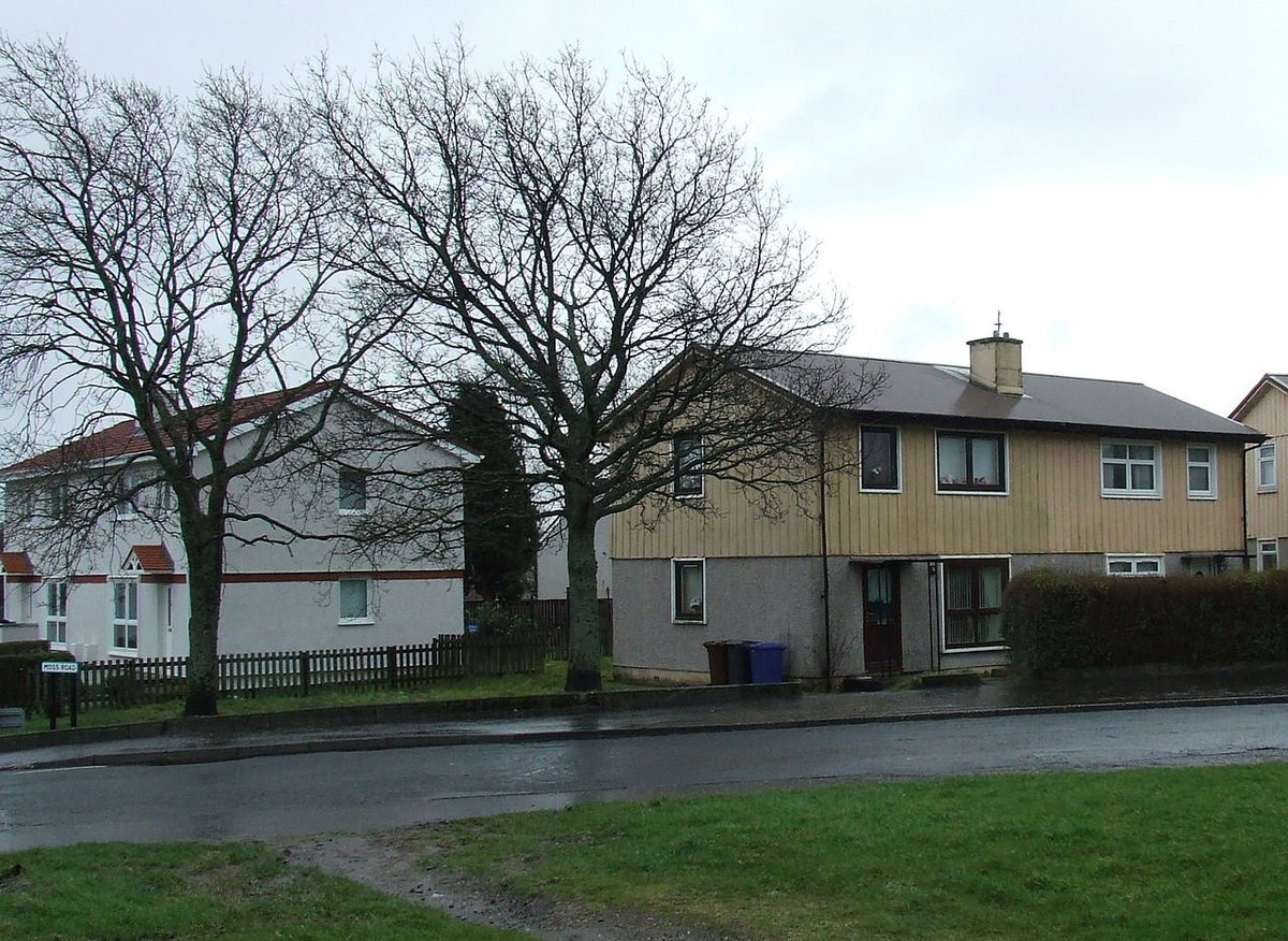
@OldEdinClub @CyclingEdin Most of "new" Burdiehouse was completed after WW2 and is composed of a type of prefab house known as a BISF (British Iron and Steel Federation). The ones below are from Port Glasgow but otherwise nearly identical. The original finish was harled ground floor and timbered upper.
@OldEdinClub @CyclingEdin The buildings are a fairly simple steel frame, with (originally) steel framed Orlit windows. The different finish to each storey gave a pleasing "rural" feel but was actually an efficient way to deal with the junction between the components
@OldEdinClub @CyclingEdin BISF houses were (and are) different from other prefabs as they were always intended to be permanent, and unlike other forms such as the ORLIT, have never been found defective and are quite mortgageable. Their lifespan is the same as contemporary brick builds.
@OldEdinClub @CyclingEdin As such, Burdiehouse has been one of the more successful council housing schemes and the buildings have all been refurbished in recent years although the loss of Critall windows and the timber panelling has totally changed the character.
@OldEdinClub @CyclingEdin 5. Golden Rings. I'm quite please with this one as I've worked in five and golden. We're talking of course about "Fiveways" and Goldenacre.
@OldEdinClub @CyclingEdin Fiveways is probably only known to regular cyclists/joggers/dog walkers of north Edinburgh, but is an obvious name for a place where 5 paths meet.
@OldEdinClub @CyclingEdin It's an old railway alignment. In reality it's one railway (the Caledonian's Leith North branch) passing across a junction (the North British's Edinburgh, Leith & Newhaven branch where the "Abbeyhill diversion" deviates from the original alignment)
@OldEdinClub @CyclingEdin flickr.com/photos/1273405… Here's an old photo, taken looking south from the top leg of the 5, the NBR lines split left to Abbeyhill and straight ahead to Scotland Street and the Caley lines run left (Leith) - right (City) across the centre.
@OldEdinClub @CyclingEdin The last line was lifted around 1986, until this point it had been retained to give access to a fuel depot at Granton. The land was transferred to Lothian Region Council who had the foresight to listen to campaigners and preserve it as pathways flickr.com/photos/1179838…
@OldEdinClub @CyclingEdin The south arm of the 5 paths (that which runs to Scotland Street), is now known as the Goldenacre Path, as it is the western boundary of that neighbourhood. As a place name, Goldenacre is relatively modern, late 18th or early 19th century
@OldEdinClub @CyclingEdin Older forms were "Goldenriggs" or "Goldenaikers" and it's not a big leap to understand they referred to some farmland. The "golden" part is quite frequently used around the Lothians and most likely refers to the growth of wildflowers of that hue
@OldEdinClub @CyclingEdin The strip of north Edinburgh along either side of Ferry Road remained relatively undeveloped until the 1860s on, until then it was largely nurseries and market gardens interspersed with the mansions of the well to do of the city.
@OldEdinClub @CyclingEdin In the late 1880s, the Edinburgh Northern Tramways ran their cable-hauled line all the way up Inverleith Row and suddenly Ferry Road became a great development prospect for upmarket tenements
@OldEdinClub @CyclingEdin It's no coincidence that the fueing of the old Goldenacre plantation (which includes Goldenacre Terrace) happened within 2 years of the arrival of the trams.
@OldEdinClub @CyclingEdin 6. Geese a-laying. The obvious (and only) place to go is back to the Guse (Goose) Dub at the west end of Crosscauseway
@OldEdinClub @CyclingEdin This is a very old name, predating any map records, but it has been commemorated with this reproduction sign
@OldEdinClub @CyclingEdin The name is fairly simple. Guse = Goose, Dub = a pond, pool or puddle (see also the Dub Raw (Row) in old Leith)
@OldEdinClub @CyclingEdin The main reason it's not on most of the earlier maps is that it's outside the city walls. Before Edinburgh began to expand itself beyond the security of its walls in the 18th century, this would have been farmland.
@OldEdinClub @CyclingEdin As the city expanded south towards the drained Boroughloch (map below Kincaid 1784), the Guse Dub found itself surrounded, but its outline retained as the gushet where the Crosscauseway meets Causewayside.
@OldEdinClub @CyclingEdin Since the pond was drained, the Goosedubs has been a bit of a neglected wedge of land that can't seem to find a purpose. For many years it was the site of a horse trough, but since the city turned itself over to motorcars has been a forlorn tarmac island cum car park
@OldEdinClub @CyclingEdin The Causey Development Trust (@The_Causey) have been trying for a long time to improve this situation, they've more on their project and the history of the Guse Dub here; thecausey.org/causeyhistory.…
@OldEdinClub @CyclingEdin @The_Causey 6. Swans a Swimming. Swanston. A veritably ancient name, probably as old as Edinburgh itself.
@OldEdinClub @CyclingEdin @The_Causey The name is first recorded in 1214 and is of Norse origin, from the given name Sveinn (modern, Sven) and the Norse or Anglian "tun" meaning a farmstead. This origin puts the age at some point in the 10th-12th centuries
@OldEdinClub @CyclingEdin @The_Causey The name is recorded as part of the medieval barony of Redhall, which occupied much of the cleft between the north slopes of the Pentlands and the back of the rising ground south of Edinburgh
@OldEdinClub @CyclingEdin @The_Causey Swanston was a farm, part of the "Templelands". These were lands granted by the Knights Templar in the 12th or 13th century to Thomas, Lord Binning, a nobleman based in East Lothian
@OldEdinClub @CyclingEdin @The_Causey In the 15th Century the farm was subfued (the Land was held for the Crown by the Laird in return for service, loyalty, tax etc. The Laird could in turn split and grant it to others in return for service or tax etc.) into Easter and Wester Swanston, with Swanston Burn the boundary
@OldEdinClub @CyclingEdin @The_Causey And so it was for the next 4 centuries that not a lot changed. Another sleepy little roadside hamlet like Burdiehouse. The 19th century brought the arrival of filter beds for the city's water supply
@OldEdinClub @CyclingEdin @The_Causey The 1930s saw the name applied to new, middle-class bungalow housing built on the south facing slopes of Fairmilehead, between the Swanston Burn and Oxgangs Road. There were further expansions in the 1950s and early 1970s, forming a well defined Swanston neighbourhood
@OldEdinClub @CyclingEdin @The_Causey Look closely though and you will see that it's not a particularly well planned neighbourhood, rather one of distinct patches. The 30s and 50s housing are form a large block. "New Swanston" of the 1970s is connected only by a few narrow paths and faces the other way.
@OldEdinClub @CyclingEdin @The_Causey "Caiyside" is a 1980s addition, named for the field on which it was built, and is connected to neither old or New Swanston, apart from by a few narrow footpaths. This is post war suburban dormitory scheme planning at its finest.
@OldEdinClub @CyclingEdin @The_Causey The name moved south, but the old centre of Swantson on the north slope of the valley was turned into a golf course at some point in the 1960s or 70s, and the old farm hamlet itself has been renovated into small business units
@OldEdinClub @CyclingEdin @The_Causey 7. Maids a Milking. An ancient name for Edinburgh Castle was the Maiden Castle, dating back into time immemorial and not really dying out in common use until the 16th Century
@OldEdinClub @CyclingEdin @The_Causey The meaning of Maidens has been lost, it may have a connection to the Arthurian legend of the Land of the Maidens, or there are other tales of Pictish princesses or nuns from which explanations have been suggested. Or it may have nothing whatsoever to do with maidens.
@OldEdinClub @CyclingEdin @The_Causey There are other Maiden or Virgin castles and forts, and one suggestion is that they describe one which has "never been taken by force".
@OldEdinClub @CyclingEdin @The_Causey 9. Drummers Drumming (yes I'm aware that there are different versions and orders of the song and 9 isn't always the drummers). Drum is an easy-peasy one given the prevalence of Drum (Gaelic, Druim) place names describing a hill or ridge. Let's take "The Drum" at Gilmerton
@OldEdinClub @CyclingEdin @The_Causey The Drum itself is the estate to the east of Gilmerton village, but the name clearly derives from the ridge of high ground on which the latter sits, to the south of Edinburgh. It's recorded as early as 1406 and is first show on a map in Adair of 1682 as a walled house
@OldEdinClub @CyclingEdin @The_Causey Drum House is early Georgian, built on top of the older 1584 house, which was built by the Lords Somerville as their family seat in a relocation from Carnwath
@OldEdinClub @CyclingEdin @The_Causey The original tower house (described as being somewhat inconveniently laid out and church-like) was replaced by the 13th Lord in the 1720s when he commissioned William Adam to design a fashionable classical country house.
@OldEdinClub @CyclingEdin @The_Causey From 1756 to 1866, the Drum was the location of the Edinburgh Mercat Cross after its removal to widen the High Street and prior to its restoration. The current cross incorporates parts of the original infilled and embellished with Victorian reproduction
@OldEdinClub @CyclingEdin @The_Causey The estate began to be broken up and sold in the 1800s and the 19th and last Lord Somerville, Aubrey John, exited and sold the Drum in the 1860s at which point the house came into the hands of the More Nisbett family of landed gentry.
@OldEdinClub @CyclingEdin @The_Causey John More Nisbett's son, Hamilton More Nisbett became an architect and ran his practice from Drum House until the 1960s. He did much of his own work making improvements and alterations to the estate and its buildings.
@OldEdinClub @CyclingEdin @The_Causey He also designed the Gilmerton Junior Friendly Society Hall, now Gilmerton Village Hall (photo Geograph, © Anne Burgess)
@OldEdinClub @CyclingEdin @The_Causey I've just realised I've stuffed up the numbers. The Guse Dub should be 6, Swanston 7, Maiden Castle 8. Then it makes sense to have The Drum as 9.
@OldEdinClub @CyclingEdin @The_Causey Are we still going? Yes we are and it's 10. Pipers Piping. I have previously gone on about "The Big Pipes" () in some detail, so for a change let's select Pipe Street in Portobello
@OldEdinClub @CyclingEdin @The_Causey Pipe Street dates back to the 1770s, when the lands to the east of the Figget (Figate) burn were fued to William Jamieson. Jamieson found a clay bed on the river bank and opened a brick and tile works. Below is a clip of Baird's sketch of John Ainslie's plan of Portobello of 1783
@OldEdinClub @CyclingEdin @The_Causey Jamieson reputedly laid a pipe from the Figate Burn at Rosefield, above the habitation and industry of Portobello, to bring fresh water to his brickworks and his workers housing at Brickfield
@OldEdinClub @CyclingEdin @The_Causey Although the brickworks were superseded by potteries and the name "Brickfield" fell out of use, it was revived for one of the names of a new housing scheme on the old site in the 1970s/80s, and another street named for Jamieson
@OldEdinClub @CyclingEdin @The_Causey 11. Lords a Leaping. Despite Edinburgh's long being the hang out and place to be for the Scottish gentry, there's only a single street address in all of Edinburgh named for a Lord, which is Lord Russell Place in Sciennes
@OldEdinClub @CyclingEdin @The_Causey Notice I've said "street address" as it's not a street, it's one of those Edinburgh curiosities that pre-date a rational system for naming streets, where the buildings on a street take a different name and address from the street itself
@OldEdinClub @CyclingEdin @The_Causey The opposing tenements are "Summerhall Place" and the road itself you might call Causewayside. Indeed Summerhall Place runs 1-13, and Causewayside addresses start at 15 to avoid confusion. Lord Russell Place is a lone series of 1-6
@OldEdinClub @CyclingEdin @The_Causey Lord Russell Place itself is a relatively standard Edinburgh late Georgian block of the early 1830s, most notable for the distinctive bowed gable end (which is marred somewhat by 2 of the 5 bays being false windows which haven't been repainted)
@OldEdinClub @CyclingEdin @The_Causey The footprint is awkward given the block is constrained by the garden ("Mr Moodie's") on which it was built. It doesn't *really* make sense for Sciennes Street not to run straight through to Causewayside, but this part of the city wasn't planned wholesale rather grew over time
@OldEdinClub @CyclingEdin @The_Causey Russell himself was not an Edinburgh native, but was the son of aristocracy who was educated at the University. As an MP he would help introduce the First Reform Act of 1832 and was Prime Minister twice, 1846-52 and 1865-66
@OldEdinClub @CyclingEdin @The_Causey Given the dates, it is most likely that the block was named in his honour because of his efforts regards voting reform rather than on the success of an Edinburgh graduate becoming Prime Minister.
@OldEdinClub @CyclingEdin @The_Causey *Correction* he never actually graduated it seems. But anyway he must have left an impression on the townsfolk as he was made a Free Burgess in 1845.
@OldEdinClub @CyclingEdin @The_Causey Can it be the Twelfth day already? Sadly it is and our 12-stop tour of Edinburgh is at an end. For 12 we're at Ladies Dancing. There are many options to choose from, there's at least 16 groups of street names with a Lady or Ladie theme. I'll go close to home with Lady Fife's Brae
@OldEdinClub @CyclingEdin @The_Causey Lady Fife's Brae is the eastern of the two "braes" (in reality, small mounds) on the otherwise flat Leith Links. The name is an easy one, it's from Lady Fife, Mary Skene, wife of Alexander Duff, 3rd Earl of Fife
@OldEdinClub @CyclingEdin @The_Causey Lady Fife took up residence in the mansion, Hermitage House, south of the brae in 1811 on the death of her husband (picture © Edinburgh City Libraries, capitalcollections.org.uk/view-item?i=35…)
@OldEdinClub @CyclingEdin @The_Causey The distinctive footprint of the mansion, with four detached wings arranged around the main building, is clear on Roy's Lowland Map of the 1750s
@OldEdinClub @CyclingEdin @The_Causey You will notice that in the 1817 map, the land ownership is recorded as "Miss Primrose". I don't actually know who Miss Primrose was, she wasn't Lady Fife and although the Primroses are the Earls of Roseberry, his daughters would have been titled "Lady Primrose"
@OldEdinClub @CyclingEdin @The_Causey Anyway, back to Lady Fife. She was apparently fond of a stroll on the Links, and the mound infront of her house was one of her preferred vantage points. It followed that the brae and the nearby well began to be associated with her
@OldEdinClub @CyclingEdin @The_Causey So what is the brae? Is it natural or man made? You'll notice that it's marked as an antiquity, "Remains of Pelham's Battery", and that's the story given on the plaques in the park and quite a few local history books.
@OldEdinClub @CyclingEdin @The_Causey Pelham's Battery, "Mount Pelham," was one of three English siegeworks constructed as firing platforms for artillery during the seige of Leith in 1560. The others were Mount Falcon and Mount Somerset, named after the commanders of each. This is Sir William Pelham
@OldEdinClub @CyclingEdin @The_Causey It's 350m from the wall, so unlike the demonstrably erronous locations popularly associated with Mounts Somerset and Falcon, it isn't too near the walls to be a suicidal location.
@OldEdinClub @CyclingEdin @The_Causey The main problems are, it's *MUCH* too small, it's too low down (it had to have a commanding firing position over the walls due to the flat trajectory of Tudor artillery) and it contradicts the written and mapped accounts. It was rather on the slope south of Hermitage House
@OldEdinClub @CyclingEdin @The_Causey So if it isn't the last remains of an artillery fortification, what is it? Well, my best guess is that when the Links, an ancient raised beach system, was being flattened and landscaped over the centuries, they simply gathered the rocks and boulders up in a convenient pile
@OldEdinClub @CyclingEdin @The_Causey The 1804 Ainslie and 1817 Kirkwood maps represent the Links as far more lumpy and bumpy then than it is now, and there are no notable hillocks called out on their own in the position of the current "Brae"
@OldEdinClub @CyclingEdin @The_Causey By the time the Ordnance Survey came along in 1840 to survey the Six Inch maps, for some reason they recoded the two prominent hillocks left on the now-flattened and landscaped Links as the remains of the 1560 batteries and thus it was for at least the next 150 years
Missing some Tweet in this thread? You can try to force a refresh.

Enjoying this thread?

Keep Current with Andy Arthur

Profile picture

Stay in touch and get notified when new unrolls are available from this author!

Read all threads

This Thread may be Removed Anytime!

Twitter may remove this content at anytime, convert it as a PDF, save and print for later use!

Try unrolling a thread yourself!

how to unroll video

1) Follow Thread Reader App on Twitter so you can easily mention us!

2) Go to a Twitter thread (series of Tweets by the same owner) and mention us with a keyword "unroll" @threadreaderapp unroll

You can practice here first or read more on our help page!

Follow Us on Twitter!

Did Thread Reader help you today?

Support us! We are indie developers!


This site is made by just three indie developers on a laptop doing marketing, support and development! Read more about the story.

Become a Premium Member ($3.00/month or $30.00/year) and get exclusive features!

Become Premium

Too expensive? Make a small donation by buying us coffee ($5) or help with server cost ($10)

Donate via Paypal Become our Patreon

Thank you for your support!