#INFA and a widening gyre.
July 22nd #Japan #Olympics2021 weather update, rain, wind, rain and more rain. This is not looking at all ok.
TL/DR: the model forecasts for East Asia have changed. And gotten significantly worse.
July 22nd #Japan #Olympics2021 weather update, rain, wind, rain and more rain. This is not looking at all ok.
TL/DR: the model forecasts for East Asia have changed. And gotten significantly worse.
Here's a high resolution satellite image of Typhoon #INFA which is continuing to defy all predictions.
But the potential impacts of this storm both for those in its path and for the wider region are getting steadily worse.
But the potential impacts of this storm both for those in its path and for the wider region are getting steadily worse.

Yesterday's thread can be found here >>
TL/DR the only hope at this point is that the models can't compute this right, and what they say will happen doesn't.
It's now time for prayer, and for Japan to prepare for widespread catastrophic rainfall.
TL/DR the only hope at this point is that the models can't compute this right, and what they say will happen doesn't.
It's now time for prayer, and for Japan to prepare for widespread catastrophic rainfall.
https://twitter.com/althecat/status/1417854867348103169?s=20
All for a storm which doesn't yet exist.
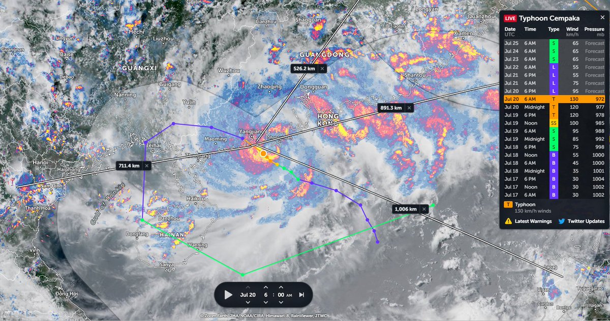
Here we are now calling this #3rdStorm. The first 2 being #Cempaka (causing catastrophic and lethal flooding in south China) and #INFA which keeps getting stronger and more menacing and has the Eastern seaboard of China in its path.
Here we are now calling this #3rdStorm. The first 2 being #Cempaka (causing catastrophic and lethal flooding in south China) and #INFA which keeps getting stronger and more menacing and has the Eastern seaboard of China in its path.
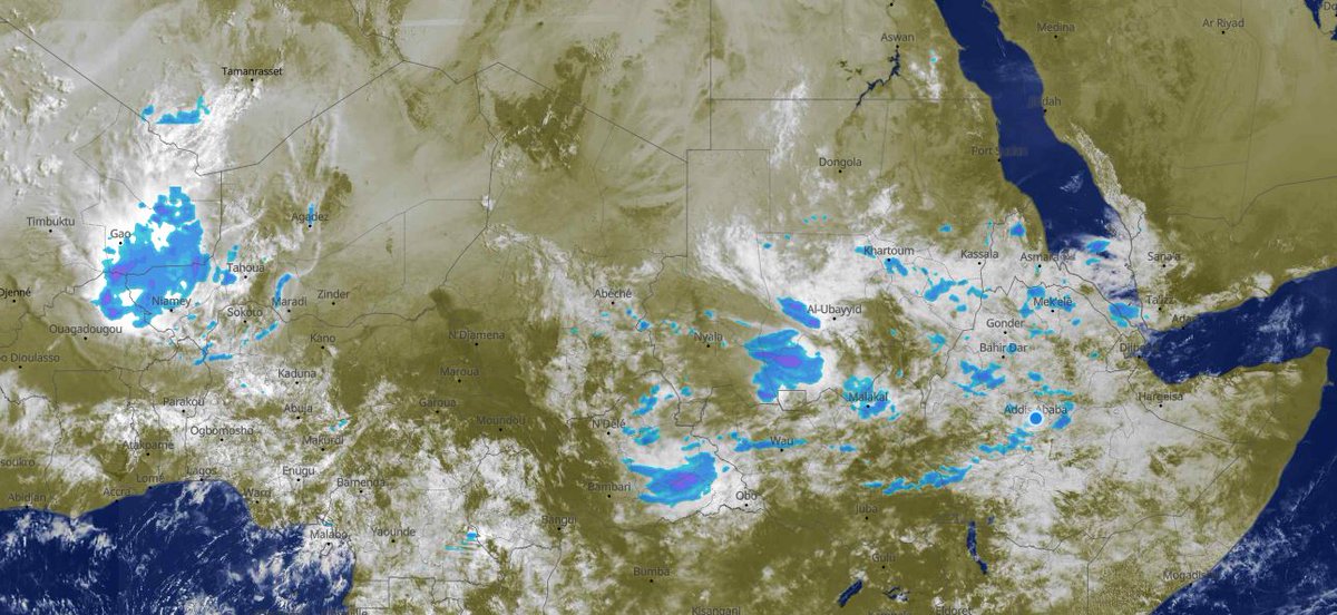
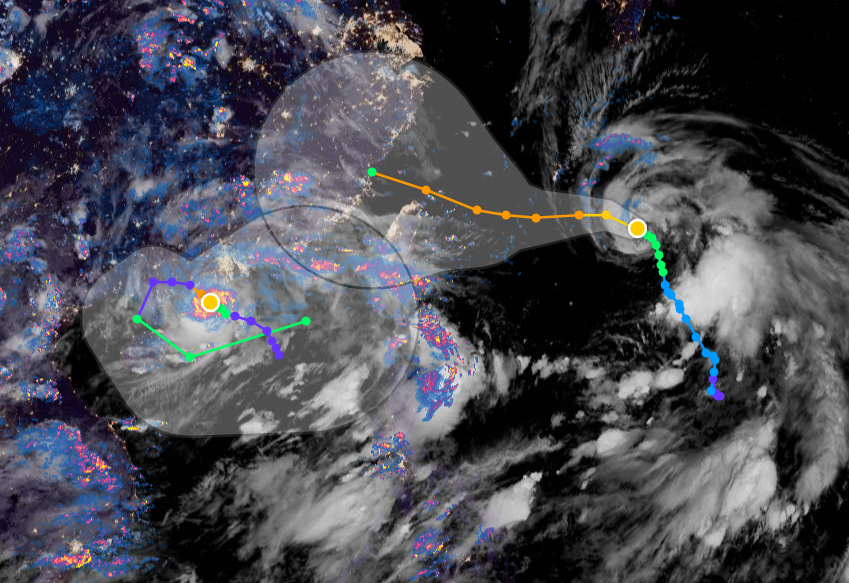
The image above from the tip of the tail of #INFA's widening gyre. And this is where 3rd storm is expected to appear (i.e. where the Cyclonegenesis is expected to begin), albeit now later than originally expected, which for me at least is now a source of hope. Here's a live view.
If you squint & look very closely at the nook of the corner to the left of the tail faint traces of what could be rotation are there.
& If there's a tropical low in there then its a mystery why it hasn't been designated by JTWC as an area of interest requiring investigation yet.
& If there's a tropical low in there then its a mystery why it hasn't been designated by JTWC as an area of interest requiring investigation yet.
A low if it is present should be rotating counter clockwise. And once we see that we will know #3rdstorm is forming.
You can watch this live here >> zoom.earth/#view=25,156.7…
You can watch this live here >> zoom.earth/#view=25,156.7…
I can see two changes in the latest model forecast.
1/ The first is that #3rdStorm development has slowed.
Left: Today's 6pm forecast for 25th July 00hrs
Right: Yesterday's forecast for 25th July 00hrs
1/ The first is that #3rdStorm development has slowed.
Left: Today's 6pm forecast for 25th July 00hrs
Right: Yesterday's forecast for 25th July 00hrs


And the 2nd difference is the intensity forecast for #INFA which is now significantly higher.
And it seems likely that it is this that is making the difference in the forecast.
And it seems likely that it is this that is making the difference in the forecast.
But since the initiation data for the latest model was run, #INFA has now strengthened still further. And it could weaken at any time too. Very Severe Cyclones can do that. Or change direction. But in this case it doesn't seem likely that #INFA will weaken.
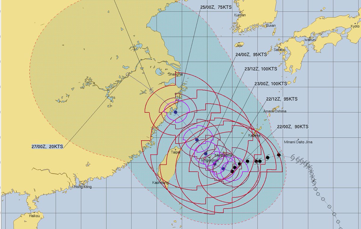

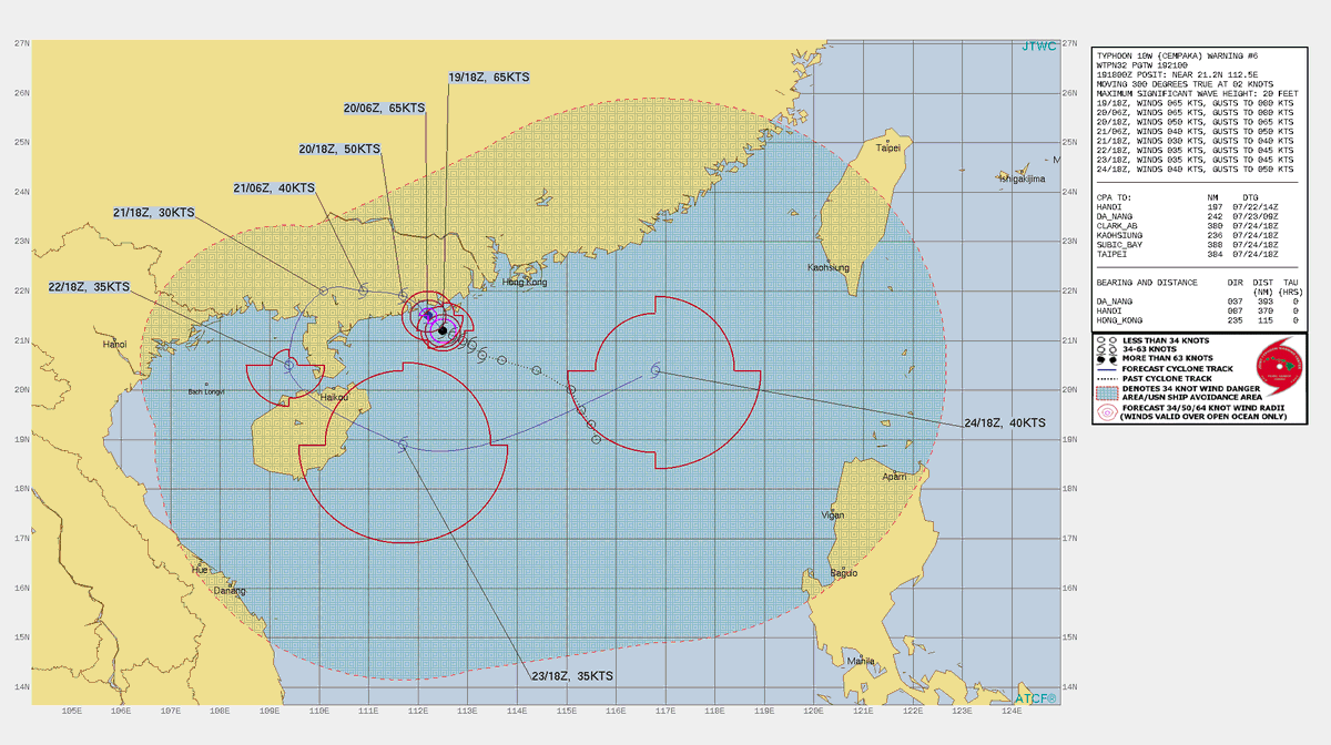
And here is the full reasoning behind their current intensity and track forecasts.
[Source: metoc.navy.mil/jtwc/jtwc.html]
[Source: metoc.navy.mil/jtwc/jtwc.html]

The texts are easily understandable.
"THE GREATEST UNCERTAINTY IN THE FORECAST IS
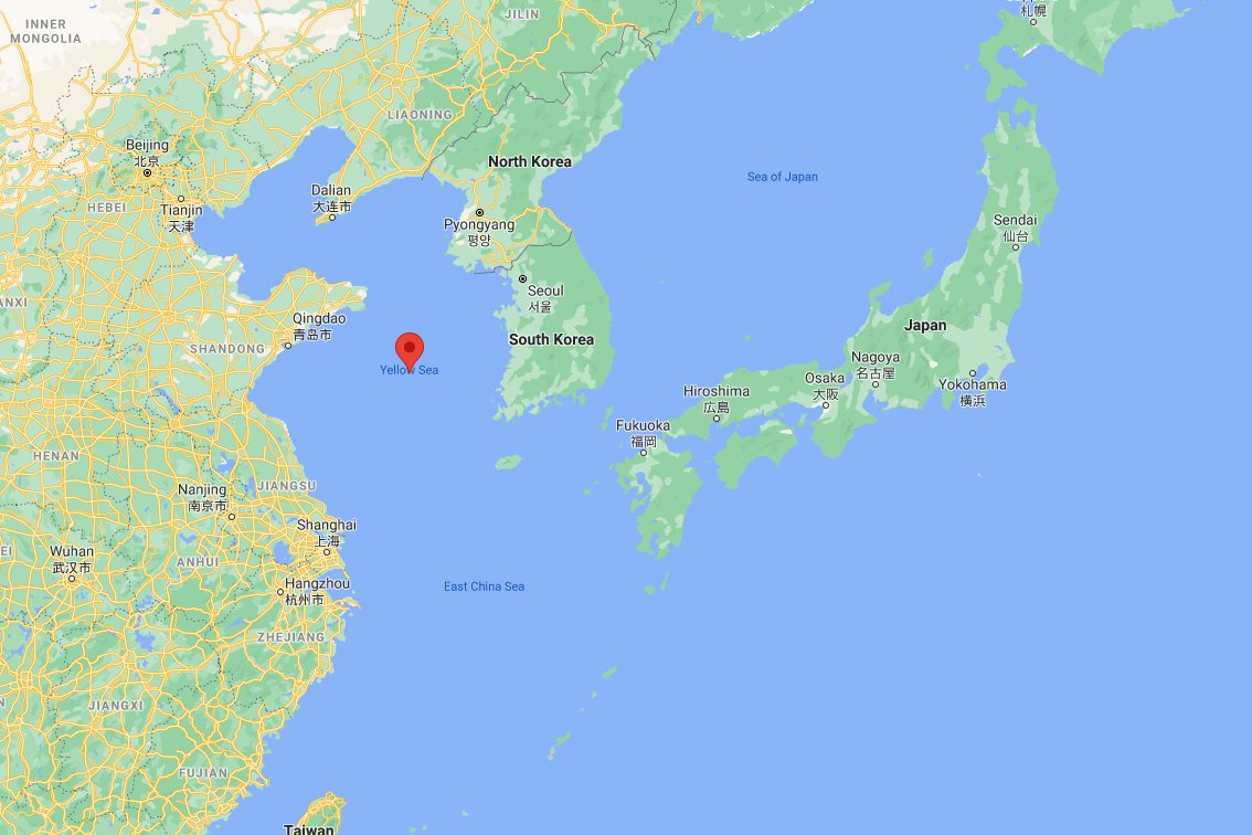
WHETHER OR NOT THE STORM TRACKS INLAND OR RECURVES ALONG THE COAST NEAR SHANGHAI AND TURNS TOWARD THE YELLOW SEA*."
NOTE: The Yellow Sea is the sea west of Korea and it leads towards Beijing.
"THE GREATEST UNCERTAINTY IN THE FORECAST IS
WHETHER OR NOT THE STORM TRACKS INLAND OR RECURVES ALONG THE COAST NEAR SHANGHAI AND TURNS TOWARD THE YELLOW SEA*."
NOTE: The Yellow Sea is the sea west of Korea and it leads towards Beijing.
The final part of the discussion is on the models.
"MODELS DISC.: JTWC TRACK FORECAST LIES CLOSE TO MODEL CONSENSUS AND THE ECMWF ENSEMBLE MEAN. THE INTENSITY GUIDANCE IS IN FAIRLY TIGHT AGREEMENT AND CONSISTENT IN TREND. THE FORECAST STAYS IN MIDDLE OF THE GUIDANCE PACKAGE."
"MODELS DISC.: JTWC TRACK FORECAST LIES CLOSE TO MODEL CONSENSUS AND THE ECMWF ENSEMBLE MEAN. THE INTENSITY GUIDANCE IS IN FAIRLY TIGHT AGREEMENT AND CONSISTENT IN TREND. THE FORECAST STAYS IN MIDDLE OF THE GUIDANCE PACKAGE."
The model shown above is the latest ECMWF above.
The GFS has a completely different view however. And the forecasts I have been mainly using have been the GFS forecasts. The GFS shows #INFA skirting the coast, far enough way to remain strong. A worst case prediction.
The GFS has a completely different view however. And the forecasts I have been mainly using have been the GFS forecasts. The GFS shows #INFA skirting the coast, far enough way to remain strong. A worst case prediction.
To make things worse in the GFS forecast (see previous tweet) #INFA slows down and does a little shimmy whilst off shore from Shanghai.
But one thing the two models agree on is #3rdStorm. The ECMWF has a slightly worse trajectory for the Olympics, but the timing, intensity and track of this (yet to appear) fast moving, not particularly strong storm is effectively identical.
In the JTWC forecast they say
"JTWC TRACK FORECAST LIES CLOSE TO MODEL CONSENSUS AND THE >> ECMWF ENSEMBLE MEAN" <>
This is the ECMWF ensemble mean model.
"JTWC TRACK FORECAST LIES CLOSE TO MODEL CONSENSUS AND THE >> ECMWF ENSEMBLE MEAN" <>
This is the ECMWF ensemble mean model.
And this is the EPS Ensemble models long-range rainfall forecast. Here we see that nearly all of Japan is forecast to get rainfall of 2 inches with peaks at a more modest 7.5 inches (20cm) but still a lot.

But this could well explain the lack of interest in the professionals in #3rdStorm. Everyone's eyes are entirely on #INFA. Here is the GEFS (GFS ensemble) model rainfall solution which is also not too bad for Japan.

Here are the latest (single model) rainfall solutions for the big two global models. 10 days
Left: ECMWF
Right: GFS
Which are similar except in relation to the Yellow Sea trajectory question. For China though the GFS model is much better.
Left: ECMWF
Right: GFS
Which are similar except in relation to the Yellow Sea trajectory question. For China though the GFS model is much better.


All that being said, I am confused as to how this PWAT forecast doesn't result more rain over Japan. Especially the bit at the end.
• • •
Missing some Tweet in this thread? You can try to
force a refresh