Dear Ethiopian Twitter followers, and those from the wider region I have been covering with rainfall forecasts for the past few months.
I will no longer be doing these daily. But that does not mean they will stop altogether, as I am hooked on the changing weather in your region.
I will no longer be doing these daily. But that does not mean they will stop altogether, as I am hooked on the changing weather in your region.

The image above is this from this morning's satellite pass. And it was the only bit visible through he cloud near the Ethiopian highlands which have been the focus of this effort. I suspect all of Ethiopia was covered but we can't see the bit in the black strip, not certain.

The reason for stopping the daily forecasts is, of course, the filling of the #GERD, that was why they started. But they led to so much more.
Today one of the things I originally started looking for happened in a spectacular way. This is a live rainfall image from 8.15 am today.
Today one of the things I originally started looking for happened in a spectacular way. This is a live rainfall image from 8.15 am today.
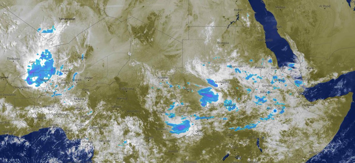
These two are at 12pm and 4pm today.The #ArabianMonsoonBurst this month is bringing #DesertRain, and it is the monsoon that is bringing this, a monsoon which is heralding a new phase in climate change. One in which the changing weather is apparent to us all.


Somehow this tweet escaped the thread :)
https://twitter.com/althecat/status/1417939997118828544?s=20
This is the special tweet that this intro was building up to.
The first image shows monsoon driven rain falling in the heart of the great Sahara desert, one of dryest places on earth, the mountains of Tamanrasset, Algeria. (en.wikipedia.org/wiki/Tamanrass…).
The first image shows monsoon driven rain falling in the heart of the great Sahara desert, one of dryest places on earth, the mountains of Tamanrasset, Algeria. (en.wikipedia.org/wiki/Tamanrass…).
And rain in Tamanrasset province Algeria is important because that is where this journey began five and a bit months ago. With this picturesque Monsoon driven rain event over InSalah and Tamanrasset.
[The satellite cloud image is also a favourite.]
https://twitter.com/althecat/status/1370348872082591744?s=20
[The satellite cloud image is also a favourite.]
So it seems like a good moment to change direction a little.
For Ethiopia #ClimateChange may be positive. But as we have seen in Germany, it can also be lethal.
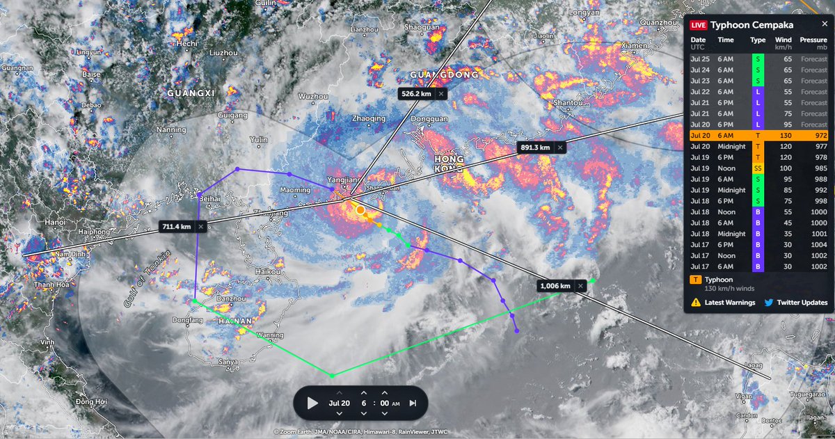
Today has brought more flooding deaths in China. 25 so far. cbsnews.com/news/flooding-…
For Ethiopia #ClimateChange may be positive. But as we have seen in Germany, it can also be lethal.
Today has brought more flooding deaths in China. 25 so far. cbsnews.com/news/flooding-…
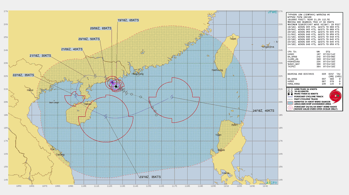
Over the past couple of weeks I have been following the causes of this China flood, which looked dangerous in model data in mid July.
As it has unfolded though it has become a bit terrifying.
As it has unfolded though it has become a bit terrifying.
https://twitter.com/althecat/status/1417860090477043712?s=20
Anyway. So where to from here.
I will not be stopping watching Ethiopian weather. And I will continue to post here on twitter about it, including probably a weekly post in a new format pointing out the interesting stuff.
I will not be stopping watching Ethiopian weather. And I will continue to post here on twitter about it, including probably a weekly post in a new format pointing out the interesting stuff.
The Big Rainy season is only three weeks old and I expect there will be many moments still to come.
The peak rainfall and flow is still some time away, and I am very curious as to what that will look like in the models. And irl on the #GERD cascade :)
The peak rainfall and flow is still some time away, and I am very curious as to what that will look like in the models. And irl on the #GERD cascade :)

I am also very interested in the political situation in Ethiopia and keen to keep watching, tweeting and possibly writing about that.
Yours is the 1st new democracy I have given life in real time. And I would like to hang with you and watch you prevail :)
Yours is the 1st new democracy I have given life in real time. And I would like to hang with you and watch you prevail :)
And that's me done for now.
I'll see you 'round here, just not quite so regularly and at such length.
Chur
Alastair
/ENDS
I'll see you 'round here, just not quite so regularly and at such length.
Chur
Alastair
/ENDS
• • •
Missing some Tweet in this thread? You can try to
force a refresh