India - State of #forest report from Forest Survey is out. If you get news articles (how forest covr increased/decreased), read it with caution. Will write detailed comments later, but some small fun for now:

In ch-13 maps, they have given Shaksgam away! Illegal to publish..
1/n
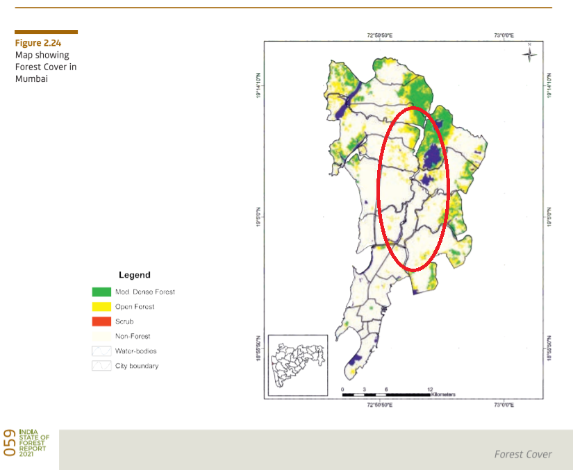
They had some city level maps of forests.. And their statistics depended on boundary files and the file for Mumbai is riddled with gaps between subdivisions. There are white patches in between because someone didnt digitize it properly and these errors creep into stats
For the other major cities, the boundaries used were municipal corporation boundaries but for Bengaluru alone they have used planning area boundary (BDA has a larger area than BBMP and covers some forest patches). Comparison shown below and this would affect numbers
And looks like the reports carry forward the same methodology used in previous reports which overreports forests. Eg: In the snapshot of Kanniyakumari district below, areas covered by Coconut, Rubber plantations are labelled as "forests". Will write in depth about this later
A detailed analysis on the results is also difficult to do as the maps cost 2000 Rupees for every 1 degree by 1 degree grid cell. Roughly 7-8 lakh rupees for the entire country.
And it comes with lots of restrictions. Even after one buys the data, the person cant copy from the CD 🤣 Considering that my laptop has no CD drive, I would have to buy an external drive.

Data policies are weird.
Anyway, I will write a more detailed thread about the methodology later..

For now, exercise caution!
I have to read through their definitions of "tribal districts" etc. In Tamil Nadu, they have classified Tiruchirappalli as a tribal district! In Census 2011, Trichy had 0.67% tribal population. 🤔
Update: State of the Forest report is no longer available in official website!

• • •

Missing some Tweet in this thread? You can try to force a refresh
 

Keep Current with Raj Bhagat P #Mapper4Life

Raj Bhagat P #Mapper4Life Profile picture

Stay in touch and get notified when new unrolls are available from this author!

Read all threads

This Thread may be Removed Anytime!

PDF

Twitter may remove this content at anytime! Save it as PDF for later use!

Try unrolling a thread yourself!

how to unroll video
  1. Follow @ThreadReaderApp to mention us!

  2. From a Twitter thread mention us with a keyword "unroll"
@threadreaderapp unroll

Practice here first or read more on our help page!

More from @rajbhagatt

7 Jan
#Thread of maps on Palayamkottai, now part of #Tirunelveli

As a city,Palayamkottai has a recorded history for more than a thousand years. It reached its zenith during the British era & was called as "Oxford of South India"

My first thread in 2022 is a tribute to #ThoPa
Palaymkottai was located in KeelKalaKootram, a revenue division in the east side of Porunai river (now called Thamirabarani). The fort itself was positioned to protect the lush farmlands & was at the intersection of the farmlands & pastures which designed its socio-cultural setup
Before the 1700s, the city was largely confined within the fort walls. But it had began expanding outside afterwards. The fort was a largely rectangular shaped structure with a number of bastions and four gates in four directions.
Read 12 tweets
27 Dec 21
Time for another short story

A small river/stream existed near Angul #Odisha. The land around it was allotted to JSPL for development...
The company thought the course of the river was too disturbing and decided to change the course of the river.
However there were other smaller streams that were draining into it (obviously) & since the new course didnt account it, they started stagnating (marked in white circle)
No matter how much they filled the land, it continued stagnating and creating issues for authorities and farmers nearby.
Read 5 tweets
5 Dec 21
Short thread of satellite images
Story of a navigational canal that was built with ~12 crore rupees tax payer money in #Ganga riverbed in #Varanasi Uttar Pradesh.

h/t @Indian_Rivers

Before the construction of the canal, this was the river Ganga
1/n
In March 2021, the construction started in the river bed where we can see the machines in action. The canal was supposed to be built parallel to the main river but within the bed.

2/n
By May, the construction had progressed and we can see the canal taking a shape (highlighted in white)

3/n
Read 9 tweets
7 Nov 21
#Thread
Many parts of #Chennai have been inundated after heavy rains (22 cm) last night. The city like all other in India faces a wide range of issues and it is UNLIKELY to solve any of the urban flooding related problems that it faces within the next 10 years.
Here's why
1/n Image
Chennai Metropolitan region (in particular the city corporation) is relatively flat terrain and is very close to sea level. The agricultural activity in the region had prompted construction of thousands of lakes which were shallow and large in area Image
Over the years, the city expanded and in many places (like South Chennai marked here) expanded in low lying areas (and wetlands) which are extremely close to sea level and water would tend to stagnate
Map shows builtup expansion Image
Read 14 tweets
24 Oct 21
Thread #Haldwani case:
After extreme rainfall in #Uttarakhand, a bridge failed across Gaula river near Haldwani

Rain wasn't sole cause, it just brought d collapse a bit earlier

Himalayan rivers exit mountains & enter plains with great intensity & it is a critical zone
It is in this critical section is Haldwani where the Gaula river exits the himalayas and enters plains. Rivers bring huge amount of sediments with them to settle as well as they have high intensity flows during monsoon to erode

Visual shows the location of the bridge that failed
Failure of a bridge is nothing new in the region. The previous bridge across the Gaula river (shown with old satellite image below) had collapsed in 2008 after floods
Read 17 tweets
16 Oct 21
#Thread - #Bengaluru Airport:
What exactly happened in Bengaluru airport that led to the flooding/stagnation a few days before?
My version:

Before the airport, area (marked in white) was in a ridge between 2 valleys, had cropland, quarries, a minor valey, open scrubland
1/n
Even after the completion of phase I which was the runway in the northern side and the terminal, the minor valley was not affected significantly as it was all limited to the northern side. One quarry site also remained holding stagnant water.
2/n
This map gives you the terrain of the airport area and one can easily notice the ridge on which it was built. Water was supposed to drain into the main valleys through the minor valley.
Approximate water flow directions are marked for better understanding of terrain
3/n
Read 8 tweets

Did Thread Reader help you today?

Support us! We are indie developers!


This site is made by just two indie developers on a laptop doing marketing, support and development! Read more about the story.

Become a Premium Member ($3/month or $30/year) and get exclusive features!

Become Premium

Too expensive? Make a small donation by buying us coffee ($5) or help with server cost ($10)

Donate via Paypal

Or Donate anonymously using crypto!

Ethereum

0xfe58350B80634f60Fa6Dc149a72b4DFbc17D341E copy

Bitcoin

3ATGMxNzCUFzxpMCHL5sWSt4DVtS8UqXpi copy

Thank you for your support!

Follow Us on Twitter!

:(