Short thread of satellite images
Story of a navigational canal that was built with ~12 crore rupees tax payer money in #Ganga riverbed in #Varanasi Uttar Pradesh.

h/t @Indian_Rivers

Before the construction of the canal, this was the river Ganga
1/n
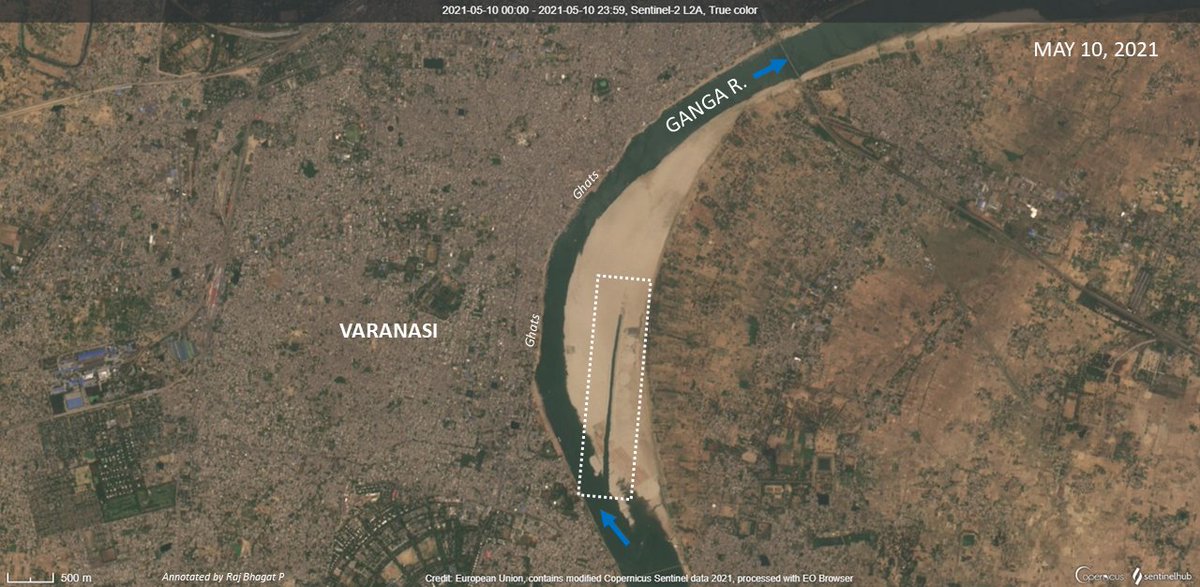
In March 2021, the construction started in the river bed where we can see the machines in action. The canal was supposed to be built parallel to the main river but within the bed.

2/n
By May, the construction had progressed and we can see the canal taking a shape (highlighted in white)

3/n
By June, most of the entire stretch was constructed and the canal was alive!

4/n
But then in August, the Ganga flooded. Only some remnants of the canal can be seen in this satellite image

5/n
By december, the canal along with our tax money is completely gone. There is no trace of it whatsoever!

The image also appears a bit hazy thanks to air pollution now. All satellite images in the thread are from @CopernicusEU @sentinel_hub
n/n
Final score:

River-1 Man-0
🤦‍♂️
A very valid question:
"Are there no river experts in India?, Why were they not consulted?"

Answer:
There are many experts but usually labelled as anti development environmentalists and are avoided. In many projects the biggest expert whom they listen to are JCB owners.

• • •

Missing some Tweet in this thread? You can try to force a refresh
 

Keep Current with Raj Bhagat P #Mapper4Life

Raj Bhagat P #Mapper4Life Profile picture

Stay in touch and get notified when new unrolls are available from this author!

Read all threads

This Thread may be Removed Anytime!

PDF

Twitter may remove this content at anytime! Save it as PDF for later use!

Try unrolling a thread yourself!

how to unroll video
  1. Follow @ThreadReaderApp to mention us!

  2. From a Twitter thread mention us with a keyword "unroll"
@threadreaderapp unroll

Practice here first or read more on our help page!

More from @rajbhagatt

7 Nov
#Thread
Many parts of #Chennai have been inundated after heavy rains (22 cm) last night. The city like all other in India faces a wide range of issues and it is UNLIKELY to solve any of the urban flooding related problems that it faces within the next 10 years.
Here's why
1/n Image
Chennai Metropolitan region (in particular the city corporation) is relatively flat terrain and is very close to sea level. The agricultural activity in the region had prompted construction of thousands of lakes which were shallow and large in area Image
Over the years, the city expanded and in many places (like South Chennai marked here) expanded in low lying areas (and wetlands) which are extremely close to sea level and water would tend to stagnate
Map shows builtup expansion Image
Read 14 tweets
24 Oct
Thread #Haldwani case:
After extreme rainfall in #Uttarakhand, a bridge failed across Gaula river near Haldwani

Rain wasn't sole cause, it just brought d collapse a bit earlier

Himalayan rivers exit mountains & enter plains with great intensity & it is a critical zone
It is in this critical section is Haldwani where the Gaula river exits the himalayas and enters plains. Rivers bring huge amount of sediments with them to settle as well as they have high intensity flows during monsoon to erode

Visual shows the location of the bridge that failed
Failure of a bridge is nothing new in the region. The previous bridge across the Gaula river (shown with old satellite image below) had collapsed in 2008 after floods
Read 17 tweets
16 Oct
#Thread - #Bengaluru Airport:
What exactly happened in Bengaluru airport that led to the flooding/stagnation a few days before?
My version:

Before the airport, area (marked in white) was in a ridge between 2 valleys, had cropland, quarries, a minor valey, open scrubland
1/n
Even after the completion of phase I which was the runway in the northern side and the terminal, the minor valley was not affected significantly as it was all limited to the northern side. One quarry site also remained holding stagnant water.
2/n
This map gives you the terrain of the airport area and one can easily notice the ridge on which it was built. Water was supposed to drain into the main valleys through the minor valley.
Approximate water flow directions are marked for better understanding of terrain
3/n
Read 8 tweets
18 Aug
Viz: #Kaveri river watershed 😍

I would be posting some #maps about the river with finer details in this thread in coming days! Bookmark.. Image
FAQ
Data: SRTM
Software: QGIS
One of the biggest engineering works in Kaveri river is the Kallanai / Grand Anicut system. It was not constructed in 1 step & most of the structure that we see were erected during British era

Annotated drone image from @vikatan. The subsequent tweets deal with history of dam Image
Read 19 tweets
26 Jun
#Story of Lakkasandra lake in #Bengaluru

The thread shows the recent history and transformations it went through over time.

#Map shows the location of lake with an approximate boundary of the plot.
The waterbody in Lakkasandra might have lost its original applications many decades ago and hence revenue maps (given on the left) shows it as a government land but not specifically as a waterbody. Google Maps however shows the waterbody as it was detected in the early 2000s
But the lake seems to have water in many satellite images from 1970s, 1980s, and 1990s. It has attributes similar to any seasonal rainfed waterbody in the region
Read 15 tweets
10 May
#Thread
#Elections are supposed to be about electing representations for framing legislations

However the geography behind delimitation which doesnt consider complex socio-economic conditions promote communal polarization leading to deterioration of Democractic values

1/n
Understanding Delmitation:

The constituency delimitation is based on population. and for last delineation exercise, 2001 population was used. Average population was calculated to be 270000 people per constituency

#Map shows Population spread in Tamil Nadu
2/n
To delineate which village/town comes under which constituency, some rules are followed

To achieve the avg population, officials start with headquarters for the constituencies in district & add villages/towns within same or neighbouring taluks(subdistricts) in same district

3/n
Read 35 tweets

Did Thread Reader help you today?

Support us! We are indie developers!


This site is made by just two indie developers on a laptop doing marketing, support and development! Read more about the story.

Become a Premium Member ($3/month or $30/year) and get exclusive features!

Become Premium

Too expensive? Make a small donation by buying us coffee ($5) or help with server cost ($10)

Donate via Paypal

Or Donate anonymously using crypto!

Ethereum

0xfe58350B80634f60Fa6Dc149a72b4DFbc17D341E copy

Bitcoin

3ATGMxNzCUFzxpMCHL5sWSt4DVtS8UqXpi copy

Thank you for your support!

Follow Us on Twitter!

:(