,
84 tweets,
14 min read
Read on Twitter
One of my big papers last semester was on the history of neighborhood associations in #Charlottesville, and how their use of zoning laws was an extension of the other exclusionary practices they used to keep their neighborhoods wealthy and white.
I am going to create a very long thread highlighting most of what I found. The details in this are obviously very geographically specific, but it is safe to say that the practices and attitudes underlying it can be found all over the country and in the histories of other cities.
This was supposed to be a map-based racial landscape argument, and towards the end I have several maps and images to show the effects of zoning over time in black and white neighborhoods, because it was a lot of work and it looks cool, haha.
I looked at neighborhood associations primarily from their foundings in the early 70s to the early 90s, when the R-1A zoning designation went into effect, codifying their exclusionary desires.
Neighborhood associations in Charlottesville began when the city was making planning decisions that, for the first time, affected white people negatively.
NAs came into existence because people liked, or, ‘more often, disliked what the city was doing.’ (Huja) A local weekly newspaper, The Observer also noted that it’s usually a crisis that sparks the creation of a neighborhood association.
The North Downtown NA formed in the late 70s to stop the construction of a large office/apt complex because it, ‘was not in keeping with the character of the neighborhood.’
The NA took the case all the way to the Virginia Supreme Court, where they lost, but by then, the delays had caused the developer to drop the project.
The Venable NA was the first NA, and it formed in the early 70s as a response to a master road plan developed by Harland Bartholomew and adopted by city council.
Bartholomew proposed turning Grady into a 4-lane road running all the way from downtown to the bypass. The residents, described as “vigilant homeowners,” stopped the project. The remnants of this project can be seen in the two left turn lanes from Preston to Grady. 

Traffic was a perpetual concern for neighborhood associations, and they worked diligently to stop projects they didn’t like.
Part of the Bartholomew Plan was for Valley Road to be widened and connected from Avon St. to Emmett at JPA, but residents complained and stopped the project, saying it would ruin good neighborhoods.
One resident presented more than 100 signatures opposing the Valley Road Project because it would introduce traffic into their area, and said that it would cause ‘mental anguish’ to residents if it was built.

Neighborhood Associations followed closely issues at city hall that would affect their way of life, and considered themselves both the city’s watchdog and its advisor.
NAs banded together under a larger org known as Cville Federation of Neighborhood Associations, whose purpose was working “for a better quality of life in the neighborhoods and in the entire city.” But the question that has to always be asked is, better quality of life for whom?
Fry's Spring:
(As seen in a 1913 issue of The Daily Progress)
(As seen in a 1913 issue of The Daily Progress)

Fry’s Spring was created to be an exciting, exclusive neighborhood with a ‘Wonderland’ building, a bandstand, and the only swimming pool in the area.
But black residents were entirely excluded from this neighborhood, and the founder of Fry’s Spring Beach Club, “was an avowed white supremacist.” Black people were not allowed to use the pool until the 1970s.
There was a historical survey of Fry’s Spring done in 2010 by NDS, and the historian who wrote the report said the residents of this neighborhood, “historically have represented the backbone of the Charlottesville community.”
She says the name Fry’s Spring, “conjures images of what most would like to think are the essence of traditional American communities.” and that the identity of Fry’s Spring as an ideal suburb has endured and thrived.
If Fry’s Spring was an area built on white exclusivity, and this is what created an image of an ideal neighborhood, and the people who lived here were the backbone of Charlottesville, it seems logical to say that Charlottesville is also built on white exclusivity. (obvs)
The name of a neighborhood speaks of income and race and history, geography, and the people who created them. How can people cling to an ideal of the past when it was founded on white supremacy without themselves being nurtured into white supremacy?
In 1985 the DP did a special issue on all the neighborhoods. Several of the whiter, wealthier neighborhoods talked about how ‘nice and quiet’ they were. (This idea of quite pops up all the time with traffic issues)
Lewis Mountain called itself an isolated, quiet oasis, and a resident described, “a very strong sense of neighborhood quality,” and they took pride in where they lived. But the neighborhood was 90% white.
In Feb 87 issue of The Observer, an article by a historical architectural writer says surveys across the country reveal that people want to live in areas that have established neighborhoods, old buildings, and, “all those old-fashioned attributes of American towns of the 1940s.”
The flipside of the coin to these neighborhoods of whiteness are neighborhoods of blackness, which means that they are the ones who have been ignored, displaced, and overruled when it comes to their communities.
In a 1995 oral history about Ridge St., longtime residents from the black side of the street talk about a pattern of neglect by the city. They described feeling as if they had to beg from the city even though they were taxpayers too, because they were black.
In the book, Urban Renewal and the End of Black Culture in Charlottesville, they describe this practice as ‘municipal neglect’ by the city to its black residents.
In every instance of a black complaint to the city that I found, they pointed out that they pay their taxes too and deserve to have their needs met, and that their issues have been unresolved for years.
In 1976 the president of the Ridge Street NA wrote to council complaining about monies intended for low-income areas (cdbg funds) being spent in the wealthy Rugby neighborhood (on the first bike lanes).
She said the neighborhood had been fighting for improvements for 15 years without success and said ‘many of our residents do not receive garbage service or home mail delivery.’
As Huja said, “many planning decisions, programs and activities are made on the neighborhood scale. Therefore it is important to understand how a neighborhood has evolved to its present state in order to direct its future development.”
According to the Blue Ribbon Commission Report, when the zoning was created, the city restricted businesses from encroaching on white residential areas, but not in the black neighborhoods.
As a result, within a few years, industries like Monticello Dairy, City Laundry, and the Triangle Service Station appeared, disrupting the black neighborhood today known as Rose Hill, but known back then as the neighborhoods of Kellytown and Tinsleytown.
If we consider that, “there were black homes all the way down Preston Avenue,” (from the hill up on High St. all the way to past Wash. Park) and we look at the 1929 zoning map, we can see the truth of that zoning difference.

In 1989, the city created a new R-1A single family zone, which affected around 4500 parcels of land. The city said the intent for the new zone was to protect single-family residences, encourage home ownership, and neighborhood stability.
One planning commission member, William Harris (the first Dean of African American Affairs at the University of Virginia & father of MHP(!)), said it was exclusionary.
He believed that it would make it harder for less wealthier people to afford housing, and that the assumption buried in this zone was that renting was not desirable.
Neighborhood involvement was essential to the creation and maintenance of downzoning to R-1A, and The Federation of Neighborhood Associations played an important part in the city adopting both stricter zoning and noise ordinances.
An example of disparity in zoning application can be seen in the summer of 1978, showing that these issues were going on even before the R-1A zone. (This is my favorite example because it’s so concise and explicit; it’s two short newspaper articles.)
A group of black residents from 10th and Page came before planning commission with a petition of 230 signatures opposing a rezoning of a piece of land between Preston Avenue and West Avenue from R to Intensive Commercial, b/c encroachment.
The Planning Commission ignored them and the vice chairman said he was approving it because he didn’t believe there was any danger to their homes.
Less than 3 months later, white residents on North 1st St. asked for 20 properties to be downzoned from high to moderate R, so the houses wouldn’t be able to used as multi-family rentals.
The same vice chairman!!!!! told this group of white people that they should be, “congratulated and saluted,” for their work in saving their neighborhood. (I believe the 10th& P area in question is where Kardinal Hall is now but I’m not positive.)
And now the main project that most of us know about - Preston Avenue.
The Barracks-Rugby-Preston NA was formed in 71 to stop a 4-lane expansion of Preston Avenue from 10th St. to Emmett St.
The Barracks-Rugby-Preston NA was formed in 71 to stop a 4-lane expansion of Preston Avenue from 10th St. to Emmett St.
Bartholomew’s team said to turn Preston into a 4-lane road from McIntire all the way to Emmett, but that widening Preston beyond 4 lanes *would be impractical*.
When residents of the Rugby neighborhood discovered the plans, they organized, signed petitions, and started attending city meetings.
For whatever reason (I have my suspicions), the city overrode the developers’ plans, and instead, from McIntire to 10th, they wanted Preston to be a 6-lane highway, and a 4-lane from 10th down to Emmett.

This widening would affect the historic black neighborhoods of Rose Hill and 10th and Page, as well as the white neighborhood of Barracks-Rugby-Preston.
In 1971, city planner Conger said that while the city had requested the Department of Highways to design a 6-lane road for Preston Avenue, he presented an alternative plan, not wanting to carelessly destroy neighborhoods, including Rose Hill.
He recommended, like Bart., that Preston be a 4-lane from McIntire to 10th, but unlike Bart, he said it should remain a 2-lane from 10th to Emmett. Conger did not want to widen the road through the Rugby neighborhood
because he was worried that it would lead to deteriorization and decline in one of the city’s, “fine, in-town neighborhoods.” But as black residents noted, Conger did not give that same care to the historic black neighborhoods.
As black resident Theresa Jackson-Price says, “We just stay on the fringe of the redevelopment all the time.”
One could argue this is the price of development, and yet the white neighborhoods have never had to undergo this type of displacement, and the black residents had not been allowed to live in those areas untouched by disruption.
Rose Hill – this is where it gets more zoning/map based, and if I was doing this again, I would have just done this neighborhood and probably gotten an A for being concise, ha!
Originally the area west of Rose Hill Drive was for black residents, and the east for whites, but in the mid-20th century, the east side was integrated.
One of the black neighborhoods on the west side was called Preston Park, and it developed in 1913. North of Preston Park was Lincoln Heights, laid out in 1922.

Like other black neighborhoods, Rose Hill suffered from municipal neglect. In 1976, the residents and property owners of Rose Hill wrote to city council describing their need for public works, attaching pages of signatures.
They said that “no significant repairs have been accomplished in over a decade.” They described contacting various city officials and being brushed aside, because their areas were not considered a priority.
They asked for sidewalks, repaved roads, lighting, and drainage. They listed 8 streets that needed public works done on, and then they closed their letter by saying,
“we are aware that our community is not in the exclusive category, yet this does not diminish our pride of ownership and desire for equal consideration as citizens and tax payers.”
In response, the (first woman) mayor of Charlottesville was pretty dismissive and told them that she didn’t think all of the streets needed all of the repairs they thought they did.
Residents formed the Rose Hill NA in the mid-80s to enhance their sense of community, and to make the neighborhood a more livable place. They felt like they might have more of a chance at being effective with the city as an association instead of as individuals.
Residents of this neighborhood have continually been concerned about business encroachment into the residential areas.
Looking at a few specific blocks of Rose Hill, we can see the effect the widening of Preston had on it, and the way that encroachment continued and brought with it demolition and displacement.
In this image of Rose Hill from 1968, the yellow and light brown areas are residential. The red and dark brown are commercial and the sky blues are light industrial.

On this land use map from 1973, all of the circles are demolished areas. Blue is single family, yellow is two family, green and pink are industrial.
The demolitions occurred in the front two blocks between Dale and Preston to prepare for the widening of Preston Avenue.
The demolitions occurred in the front two blocks between Dale and Preston to prepare for the widening of Preston Avenue.

We can see what the before and after looked like in these two aerial views from 1970 and 1980.


This is the aerial views side by side for comparison.

This is the neighborhood on the 2003 zoning map. What you notice here is not only are those two front blocks between Dale and Preston turned into the entrance corridor zoning,

but the block in red on the east side of Rose Hill, as well as the section of red on the west side of Rose Hill, which are now commercial, but used to be majority residential.
What these images show is how encroachment and destruction of this historical black neighborhood has continued up until nearly the present day, because the lack of protections Rose Hill has had in the city code has left it vulnerable to continued demolitions.

What makes these zoning changes and lack of encoded protection all the more obvious is pulling back and looking at the city as a whole over time.
I hand-outlined 6 neighborhoods over time to show lack of zoning changes. Starting at the top and going counter-clockwise, Greenbrier, Barracks-Rugby, Venable, Lewis Mtn, Fry’s Spring, and Johnson’s Village.

You can see that in that map there is some residential density creeping into the neighborhoods through the shaded areas of brown.
Here, after the R-1A zoning ordinance has passed, those areas of creep are gone, and these 6 areas in light yellow are all single-family zoned.

And we can see that in 2003, these areas still were zoned for single-family density.

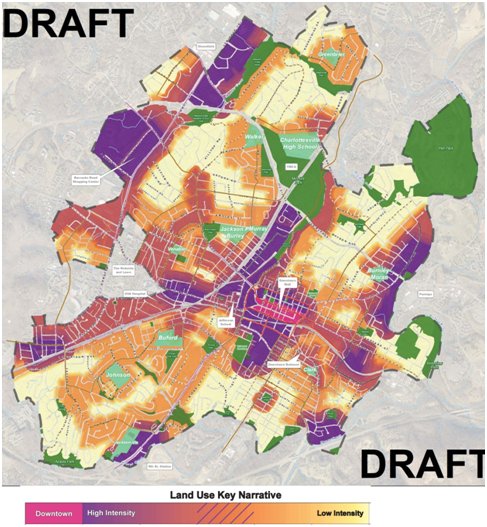
I know this new proposed land use map is up for debate and change, but you can see the difference in those 6 areas (I forgot to outline this one).
In sum:
A desire for a mythical peaceful past that white citizens have, that was rooted in segregation and white supremacy, informed the way the city developed.
A desire for a mythical peaceful past that white citizens have, that was rooted in segregation and white supremacy, informed the way the city developed.
The white neighborhoods that became R-1A were developed when blacks were not allowed to live in them. But once they could,
because of severe income disparities and wealth lost through the destruction of black neighborhoods like VH, few black people in Charlottesville could afford to move into those neighborhoods.
The segregation in race and wealth in Charlottesville was intentionally created, and the influences of zoning and neighborhood association activity could be felt all across the city, and this is the legacy that needs to be honestly addressed moving forward.
(I still maintain that this sort of information needs to be taught to city planners and other NDS staff and council, as well as all of them undergoing racial justice/equity training. We can’t do better until we know better.)